| Locality type: | Pegmatite Field |
| Classification |
|---|
|
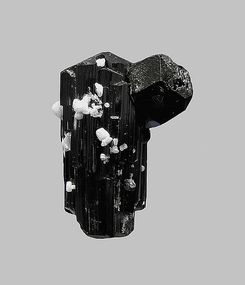
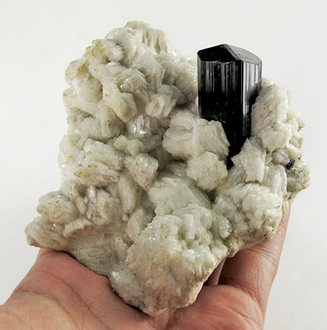
| Species: | Schorl |
| Formula: | NaFe32+Al6(Si6O18)(BO3)3(OH)3(OH) |
| Confirmation |
|---|
|
| Validity: | Believed Valid |
| Associated Minerals Based on Photo Data: |
|---|
|
| Albite | ⓘ43 photos of Schorl associated with Albite at this locality. |
| Muscovite | ⓘ17 photos of Schorl associated with Muscovite at this locality. |
| Morganite | ⓘ16 photos of Schorl associated with Morganite at this locality. |
| Aquamarine | ⓘ11 photos of Schorl associated with Aquamarine at this locality. |
| Topaz | ⓘ10 photos of Schorl associated with Topaz at this locality. |
| Cleavelandite | ⓘ6 photos of Schorl associated with Cleavelandite at this locality. |
| Quartz | ⓘ5 photos of Schorl associated with Quartz at this locality. |
| Goshenite | ⓘ3 photos of Schorl associated with Goshenite at this locality. |
| Spessartine | ⓘ3 photos of Schorl associated with Spessartine at this locality. |
| Elbaite | ⓘ3 photos of Schorl associated with Elbaite at this locality. |
| Data |
|---|
|
| Mineral Data: | Click here to view Schorl data |
| Locality Data: | Click here to view Dara-e-Pech pegmatite field, Dara-e-Pech District, Kunar, Afghanistan |
| Photo Gallery | View Gallery (13 photos) |
| Data Identifiers |
|---|
|
| Mindat Occurrence Record ID: | 47791 |
| Long-form Identifier: | 1:3:47791:0 |
| GUID (UUID V4): | 10f6ccc6-6c8c-4e52-b653-d492aa6f0d24 |
| Localities for Schorl in this Region |
|---|
|
| Awlaghal pegmatite, Dara-e-Pech pegmatite field, Dara-e-Pech District, Kunar, Afghanistan |
| Nearest other occurrences of Schorl |
|---|
|
|
| 8.8km (5.5 miles) | ⓘAwlaghal pegmatite, Dara-e-Pech pegmatite field, Dara-e-Pech District, Kunar, Afghanistan |
| 23.0km (14.3 miles) | ⓘChawkay pegmatite field, Chawkay District, Kunar, Afghanistan |
| 45.1km (28.0 miles) | ⓘDarrah-e-Nur pegmatite field, Dara-i-Nur District, Nangarhar, Afghanistan |
| 47.3km (29.4 miles) | ⓘYaryghul pegmatites, Parun pegmatite field, Nuristan, Afghanistan |
| 48.5km (30.1 miles) | ⓘKorgal pegmatite field, Nurgaram District, Nuristan, Afghanistan |
| 52.9km (32.8 miles) | ⓘParun pegmatite field, Nuristan, Afghanistan |
| 57.7km (35.8 miles) | ⓘNilaw pegmatites, Nilaw-Kolum pegmatite field, Nuristan, Afghanistan |
| 63.4km (39.4 miles) | ⓘKarbah pegmatite field, Qarghayi District, Laghman, Afghanistan |
| 65.9km (40.9 miles) | ⓘPaprok, Kamdesh District, Nuristan, Afghanistan |
| 66.0km (41.0 miles) | ⓘPachigram pegmatite field, Nuristan, Afghanistan |
| References |
|---|
|
|
| Reference Search (possible matching items) |
|---|
 | | Catalog/List | | Merelani Hills, Lelatema Mountains, Simanjiro District, Manyara Region, Tanzania 2.55 cm tall x 3.2 cm...Madagascar. Africa 17 AT L A S Malkhan, RU Dara-e-Pech, AF Shengus, PK Qinglong, CN A journey through...perception of the species. At the remote region of Afghanistan, towering mountains, junction of the Karako...miners bring down specimens. tacular aquamarine and schorl tourmaline combina- This includes a newly discovered... Rubellite Tourmaline on Cleavelandite Malkhan Pegmatite Field, Krasnyi Chikoy, Zabaykalsky Krai, Russia 19 |  | | Catalog/List | | 72002 Gold Nugget Ganes Creek Mine, Innoko Mining District Yukon-Koyukuk Census Area Alaska, USA The dimensionality... 72004 Gold Nugget Ganes Creek Mine, Innoko Mining District Yukon-Koyukuk Census Area Alaska, USA This simplistic...72005 Gold Nugget Ganes Creek Mine, Innoko Mining District Yukon-Koyukuk Census Area Alaska, USA This Gold...72006 Gold Nugget Ganes Creek Mine, Innoko Mining District Yukon-Koyukuk Census Area Alaska, USA Somewhat... 72011 Gold Nugget Ganes Creek Mine, Innoko Mining District Yukon-Koyukuk Census Area Alaska, USA There is |
|


Dara-e-Pech pegmatite field, Dara-e-Pech District, Kunar, Afghanistan