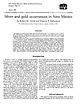
Log InRegister
Quick Links : The Mindat ManualThe Rock H. Currier Digital LibraryMindat Newsletter [Free Download]
Home PageAbout MindatThe Mindat ManualHistory of MindatCopyright StatusWho We AreContact UsAdvertise on Mindat
Donate to MindatCorporate SponsorshipSponsor a PageSponsored PagesMindat AdvertisersAdvertise on Mindat
Learning CenterWhat is a mineral?The most common minerals on earthInformation for EducatorsMindat ArticlesThe ElementsThe Rock H. Currier Digital LibraryGeologic Time
Minerals by PropertiesMinerals by ChemistryAdvanced Locality SearchRandom MineralRandom LocalitySearch by minIDLocalities Near MeSearch ArticlesSearch GlossaryMore Search Options
Search For:
Mineral Name:
Locality Name:
Keyword(s):
 
The Mindat ManualAdd a New PhotoRate PhotosLocality Edit ReportCoordinate Completion ReportAdd Glossary Item
Mining CompaniesStatisticsUsersMineral MuseumsClubs & OrganizationsMineral Shows & EventsThe Mindat DirectoryDevice SettingsThe Mineral Quiz
Photo SearchPhoto GalleriesSearch by ColorNew Photos TodayNew Photos YesterdayMembers' Photo GalleriesPast Photo of the Day GalleryPhotography

Wollastonite from
Lone Eagle Mine, Baboquivari Mining District, Baboquivari Mountains, Pima County, Arizona, USA


Locality type:Mine
Classification
Species:Wollastonite
Formula:Ca3(Si3O9)
Confirmation
Validity:Believed Valid
Data
Mineral Data:Click here to view Wollastonite data
Locality Data:Click here to view Lone Eagle Mine, Baboquivari Mining District, Baboquivari Mountains, Pima County, Arizona, USA
Data Identifiers
Mindat Occurrence Record ID:536731
Long-form Identifier:1:3:536731:3
GUID (UUID V4):807068fa-5865-40a8-a05b-9fa493d73561
Nearest other occurrences of Wollastonite
51.4km (32.0 miles) Silver Bell Mine, Mineral Mountain, Silver Bell Mining District, Silver Bell Mountains, Pima County, Arizona, USA
53.2km (33.0 miles) Atlas Mine, Silver Bell Mining District, Silver Bell Mountains, Pima County, Arizona, USA
57.4km (35.7 miles) Mineral Hill Mines (Azurite group; Old Azurite Mine; Copper Glance Mine), Mineral Hill, Mission complex, San Xavier, Pima Mining District (Olive Mining District; Mineral Hill Mining District; Twin Buttes Mining District), Sierrita Mountains, Pima County, Arizona, USA
59.7km (37.1 miles) Mission pit, Mission complex, San Xavier, Pima Mining District (Olive Mining District; Mineral Hill Mining District; Twin Buttes Mining District), Sierrita Mountains, Pima County, Arizona, USA
59.8km (37.1 miles) Mission Mine (Mission underground mine), Mission complex, San Xavier, Pima Mining District (Olive Mining District; Mineral Hill Mining District; Twin Buttes Mining District), Sierrita Mountains, Pima County, Arizona, USA
60.8km (37.8 miles) Mission complex, San Xavier, Pima Mining District (Olive Mining District; Mineral Hill Mining District; Twin Buttes Mining District), Sierrita Mountains, Pima County, Arizona, USA
62.9km (39.1 miles) Twin Buttes Mine, Twin Buttes, Pima Mining District (Olive Mining District; Mineral Hill Mining District; Twin Buttes Mining District), Sierrita Mountains, Pima County, Arizona, USA
86.8km (53.9 miles) Helvetia-Rosemont Mining District, Pima County, Arizona, USA
88.3km (54.9 miles) Leader Mine, Leader Hill, Helvetia, Helvetia-Rosemont Mining District, Pima County, Arizona, USA
88.5km (55.0 miles) Copper World Mine, Helvetia, Helvetia-Rosemont Mining District, Pima County, Arizona, USA
References
Reference Search (possible matching items)
Map
silver and/or gold have been identified in 153 mining districts or prospect areas of New Mexico. Production...significant precious metals as a byproduct of basemetal mining include the carbonate-hosted lead-zinc, copper...degrees of importance have been reported from 153 mining districts or geographical areas in New Mexico (map...oz/ton) gold or 14 ppm (0.41 oz/ton) silver. Any district that reported production of gold or silver is...an occurrence. The most accepted name of each district is listed in Table 3; common synonyms are listed
Map
resource map 24 Mining Districts and Prospect Areas in New Mexico by Virginia T. McLemore edited by...New Mexico Institute of Mining and Technology Socorro, New Mexico 2017 Mining Districts and Prospect...Resources Nelia Dunbar, Director and State Geologist Mining Districts and Prospect Areas in New Mexico by Virginia...Maureen Wilks A division of New Mexico Institute of Mining and Technology Dr. Stephen G. Wells, President...1800s from 246 mining districts and prospect areas (excluding coal, oil and gas). Today, mining is still an
Report (volume)
I.M.E., Mining Geology Geophysics Div. Ann. Mtg., Min. Br. Abs.-American Institute of Mining and Metallurgical...Metallurgical Engineers, Mining, Geology,. and Geophysics Division Annual Meeting, Mining Branch Abstracts....New York. A.I.M.E. Trans.-American Institute of Mining, Metallurgical, and Petroleum Engineers Transactions...Alberta. Canadian Inst. Mining and Metallurgy Trans.-Canadian Institute of Mining and Metallurgy Transactions...-Canadian Mining Journal. Gardenvale, Quebec. Canadian Min. Metall. Bull.-Canadian Mining and Metallurgical
Report (volume)
B. N., 17. Specialization: Link, T. A. , 14. Arizona, northern, oil and gas Geological research on ore...the future: Just, E. ing: Burwell, E. B., Jr., 4. Mining geology, retrospect and Index fossils: Stephenson... Landform interpretation, stereoSearch for new mining districts: Nolan, T. B., 1. pairs: Powers, W. E...described. Div. Mines, 1; Jenkins, O. P., Choctaw County, Highway 17 area: 3. Toulmin, L. D., Jr., 3. Minor:...limestone: Lamar, Shotts, R. C., 5. J. E., 11. Gold, mining districts: Pallister, Trace elements and potash
Book
70% is in New Mexico, 16% in Colorado, Utah, and Arizona, and 8% in Wyo1ning. These figures are a measure...doubtless the U.S.S.R., likewise established uranium mining industries. These efforts in the Reid and in the...deposit, Great Bear Lake, Canada; Gold.fields district, Canada) (Fig. '2.7). Brecciated pitchblende 111ay...and quartz (black) which also replaces core. Bigay mine, Lachaux, Auvergne, France ( X 100) ( Geffroy and...Canada and Schneeberg, Saxony. In the Blind River district of Ontario :fine-grained euheclral uraninite occurs
Report (volume)
are as follows: COLORADO. Mineralogy. Montrose County, uranium-vanadium deposits: Weeks, A. D., 13R....Iron, Cook County, titaniferous magnetite: Grout, F. F., 5. IRON. Minnesota, Cook County, titaniferous...and have not been searched completely. A.I.M.E., Mining Geology Geophysics Div. Ann. Mtg., Abs. Tech. Papers;...Br. Abs. American Institute of Mining and Metallurgical Engineers, Mining, Geology, and Geophysics Division...Technical Papers; Mining Branch Abstracts. New York. A.I.M.E. Trans. American Institute of Mining, Metallurgical
Journal (issue)
and mineral collecting in the Arkansas Ouachita Mountains during October (Smith 1970). The trip was so suc...in the 1980s, and there was a great increase in mining and specimens. Even in 1970, most of the top quality...this location in Garland County, even though much was labeled Montgomery County, Pencil Bluff, Hot Springs...material. As at Mauldin Mountain in Montgomery County, there are some 1 to 2 cm spheres that are called...crystals was collected and some natrolite in wollastonite. Several small red to pink masses of eudialyte
 
and/or  
Mindat Discussions Facebook Logo Instagram Logo Discord Logo
Mindat.org is an outreach project of the Hudson Institute of Mineralogy, a 501(c)(3) not-for-profit organization.
Copyright © mindat.org and the Hudson Institute of Mineralogy 1993-2024, except where stated. Most political location boundaries are © OpenStreetMap contributors. Mindat.org relies on the contributions of thousands of members and supporters. Founded in 2000 by Jolyon Ralph.
Privacy Policy - Terms & Conditions - Contact Us / DMCA issues - Report a bug/vulnerability Current server date and time: May 4, 2024 12:13:48
Go to top of page