 | | Report (chapter) | | of Mining in the Southeast Missouri Lead District and Description of Mine Processes, Regulatory Controls...Controls, Environmental Effects, and Mine Facilities in the Viburnum Trend Subdistrict By Cheryl M. Seeger1...Mining Issues in Southeastern Missouri Edited by Michael J. Kleeschulte Missouri Department of Natural Resources...............................................7 Missouri Lead Study....................................................10 Early Mining in Southeastern Missouri.............................................. |  | | Report (issue) | | deposits of selected mines in the VIBURNUM TREND, MISSOURI ~ _. 0 0 w (!) a: ..J <{ a: ::> I~ z...DEPOSITS OF SELECTED MINES IN THE VIBURNUM TREND, MISSOURI: Mo. Dept. of Nat. Resources, Geological Survey... CONTENTS 1 introduction to the southeast missouri lead district page 3 stratigraphic and facies...magmont mine page 21 4 buick mine page 31 5 fletcher mine page 41 6 ozark lead company mine page...deposits of selected mines in the VIBURNUM TREND, MISSOURI J ,. . ~:·~ ;i. ' 1'......,,,11o.-~ l'o.,.. |  | | Journal (article/letter/editorial) | | Oklahoma, Kansas, and Missouri and the world-class Viburnum Trend of southeastern Missouri. Deposits in both...districts. THE TRI-STATE DISTRICT History of the Missouri Portion of the Tri-State District The Tri-State...Tri-State district, extending from southwestern Missouri through Kansas into Oklahoma (fig. l), was one of the...small-scale mining in 1849 on Turkey Creek in Joplin, Missouri (Dressel 1989). The history of the district is...and was titled “Minerals of the Vanadinite Mine, Mohave County, Arizona.” 400 ROCKS 81 MINERALS rized |  | | Journal (article/letter/editorial) | | SHERWOOD 106A East 25th, P. 0. Box 436 Oak Grove, Missouri 64075-0436 Downloaded by [Brown University Library]...Louis, Missouri 63129-2704 Figure 1. Counties in Missouri. N o comprehensive list of Missouri mineral...found in Missouri; two of these, fletcherite and starkeyite, were first described from Missouri mines....location a~ included at the end of each entry. Adair County Chariton River (40-04-05N 92-4 I -23W). septarian...septarian concretions about 2 miles north of the Macon county line. CALCITE crystals enclosing bundles of acicular |  | Brannon, Joyce C, Podosek, Frank A, Viets, John G, Leach, David L, Goldhabe, Martin, Rowan, E.Lanier (1991) Strontium isotopic constraints on the origin of ore-forming fluids of the Viburnum Trend, southeast Missouri. Geochimica et Cosmochimica Acta, 55 (5) 1407-1419 doi:10.1016/0016-7037(91)90317-x | Journal (article/letter/editorial) | | ore-forming fluids of the Viburnum Trend, southeast Missouri ‘repayment JOYCE C. BRANNON,’FRANK A. PODOSEK...Louis, MO 63 130, USA *US Geological Survey, PO Box 24056, MS 973, Denver. CO 80225, USA (Received June...mineralization in the Viburnum Trend in southeast Missouri. Separate measurements were made for fluid inclusions...in other samples, notably main-stage octahedral galena, fluid inclusion Sr composition is within the range...the Viburnum Trend (New Lead Belt) in southeast Missouri. The isotopic composition of Sr is a useful tracer |  | | Report (issue) | | Concerning Lead Mining Issues in Southeastern Missouri Scientific Investigations Report 2008–5140 U...M. Besser, U.S. Geological Survey). Bottom, West Fork Mine (photograph courtesy of Michael J. Kleeschulte...Concerning Lead Mining Issues in Southeastern Missouri Edited by Michael J. Kleeschulte Contributions...concerning lead mining issues in southeastern Missouri: U.S. Geological Survey Scientific Investigations...the Viburnum Trend Subdistrict of southeastern Missouri has occurred for more than 40 years. Additional |  | | Journal (article/letter/editorial) | | minerals Article Platy Galena from the Viburnum Trend, Southeast Missouri: Character, Mine Distribution, Paragenetic...Petroleum Engineering, Missouri University of Science and Technology, Rolla, MO 65401, USA; rhagni@mst.edu Received:...southeast Missouri is one of the world’s largest producers of lead. The lead occurs as galena, predominantly...cubes. Many studies have shown that octahedral galena is paragentically early, the more abundant of the...minor octahedral modifications. Viburnum Trend galena crystals that exhibit a platy form have received |  | Shelton, K.L., Burstein, I.B., Hagni, R.D., Vierrether, C.B., Grant, S.K., Hennigh, Q.T., Bradley, M.F., Brandom, R.T. (1995) Sulfur isotope evidence for penetration of MVT fluids into igneous basement rocks, southeast Missouri, USA. Mineralium Deposita, 30 (5) doi:10.1007/bf00202278 | Journal (article/letter/editorial) | | fluids into igneous basement rocks, southeast Missouri, USA K.L. Shelton 1, I.B. Burstein 1, R.D. Hagni...Geological Sciences, University of Missouri, Columbia, Missouri 65211 USA 2 Department of Geology and Geophysics...Geophysics, University of Missouri, Rolla, Missouri 65401 USA 3 Department of Geology and Geological Engineering...Colorado 80401 USA 4 Magmont Mine, Cominco American Incorporated, Bixby, Missouri 65439, USA s Leica Inc...60015 USA Received: 1 December 1994/Accepted: 24 April 1995 Abstract. Previous studies of galena and sphalerite |  | Appold, M. S., Numelin, T. J., Shepherd, T. J., Chenery, S. R. (2004) LIMIST ON THE METAL CONTENT OF FLUID INCLUSIONS IN GANGUEMINERALS FROM THE VIBURNUM TREND, SOUTHEAST MISSOURI, DETERMINED BY LASERABLATION ICP-MS. Economic Geology, 99 (1) 185-198 doi:10.2113/gsecongeo.99.1.185 | Journal (article/letter/editorial) | | GANGUE MINERALS FROM THE VIBURNUM TREND, SOUTHEAST MISSOURI, DETERMINED BY LASER ABLATION ICP-MS MARTIN S...the ores of the Viburnum Trend of the Southeast Missouri district have long been recognized to be sedimentary...metal content were circulating through southeast Missouri during the time of Mississippi Valley-type mineralization...the data show that fluid entering the Southeast Missouri district was not pervasively metal rich throughout...-14 $6.00 the Southeast Missouri district (Fig. 1). The Southeast Missouri ores are dominated by lead |  | | Journal (issue) | | presentation, “Minerals of Stove Mountain, El Paso County, Colorado” by Gary Zito, Colorado School of Mines...minerals is located near the Gold Camp Road, just west of Colorado Springs. All are welcome to attend....Dealers 2014 Gem and Mineral Show” at the Jefferson County Fairgrounds, Exhibit Building; Golden, CO; no admission...metric tons per year). The last major U.S. nickel mine, near Riddle, Oregon (Glenbrook Nickel Company)...fully; however, one positive note is that a new mine has recently opened in Michigan and the USGS reports |  | McClung, Craig, Bair, Dorinda, Leach, David L. (1998) Bibliography pertaining to the Ozark Mississipi Valley-type metallogenic province, Missouri, Arkansas, Kansas, and Oklahoma, USA covering 1785 to February 1998; paper edition. Open-File Report Vol. 1998 (98-238) US Geological Survey doi:10.3133/ofr98238 | Report (issue) | | VALLEY-TYPE METALLOGENIC PROVINCE, MISSOURI, ARKANSAS, KANSAS, AND OKLAHOMA, USA COVERING 1785 TO FEBRUARY 1998;...smaller Northern Arkansas, Central Missouri, and Southeast Missouri barite districts. This report provides...list of the Mississippi Valley-type districts of Missouri and key words relating to mining, MVT's, base...the same operation on the water resources of the Missouri by using the Water Resources Abstracts, a CD ROM...relating to the carbonate-hosted leadzinc deposits of Missouri. Acknowledgments We would like to thank John |  | | Journal (article/letter/editorial) | | Multiple Fluids and Fluid Sources in the Southeast Missouri Mississippi Valley-Type District: Halogen-87Sr/86Sr-δ18O-δ34S...of Geological Sciences, University of Missouri, Columbia, Missouri 65211 Pickens School of Geology, Oklahoma...Geology and Geography, Northwest Missouri State University, Maryville, Missouri 64468 Abstract Replacement...approach to the Bonneterre Dolomite of southeast Missouri, which hosts the world-class Viburnum Trend Mississippi...during ore deposition. Main-stage cuboctahedral galena (δ34S ~15‰) has fluids with Cl/Br molar ratios |  | | Journal (issue) | | and TwinnedFornacite from the Singer Mine, Goodsprings, Clark County, Nevada Paul M. Adams 126 S. Helberta...Helberta Ave. #2 Redondo Beach, CA 90277 • The Singer Mine is located on the south end of Bonanza Hill, in...southwest of Goodsprings, Clark County, Nevada. Goodsprings is located 7 miles west of Jean, NV and can be reached...Ersknie Ross of Los Angeles and J. H. Polk. The mine operated from 19I 3 to I 920, during which time...of radiating sprays of willemite crystals, Singer Mine, Goodsprings, Nevada. Recent Collecting Activities |  | Mavrogenes, John A., Hagni, Richard D., Dingess, Paul R. (1992) Mineralogy, paragenesis, and mineral zoning of the West Fork Mine, Virburnum Trend, Southeast Missouri. Economic Geology, 87 (1) 113-124 doi:10.2113/gsecongeo.87.1.113 | Journal (article/letter/editorial) | | and Mineral Zoning of the West Fork Mine, Viburnum Trend, Southeast Missouri JOHNA. MAVROGENES,* RICHARDD...Departmentof Geologyand Geophysics,Universityof Missouri-Rolla,Rolla, Missouri65401 AND PAUL R. DINGESS..., Rt 1, Box 202C, Bunker, Missouri 63629 Abstract ASARCO'sWest Fork mine, the newestmine in the ViburnumTrend...mineralzoningpatterns.The distinctmineral zoningpresentat the West Fork mine providesa unique opportunityto relate mineral...Principalmetallicsulfidesin the oresat theWest Fork mineare PbS(galena),ZnS(sphalerite andwurtzite), and FeS2(pyrite |  | | Report (issue) | | Weinrich Minerals (danweinrich.com) had many superb galena specimens from a strike “within the last few months”...Big Bear orebody in the Fletcher mine, Viburnum Trend, Reynolds County, Missouri; these include many which...show large, sharp, lustrous spinel-law twins of galena. Now an April 8 update to the Weinrichs’ site announces...announces that more, brand-new (i.e. post-Tucson) galena specimens have been taken from the same occurrence...other specimens showing brilliantly lustrous cubic galena crystals set among much smaller crystals, with |  | | Journal (article/letter/editorial) | | ViburnumTrend-typefluidscontainslessradiogeniclead than galena depositedby Tri-State-typefluids.Sulfldesdepositedby...Sheltonet al., 1986). Leach THE Ozarkregionof Missouri,Kansas,Oklahoma,and andRowanhave (1986) proposedthat...smaller Introduction Northern Arkansas, Central Missouri, and Southeast korea foreland basin. These fluids....... -'" Reelfoot Rift sBasin /! CJ(e• C. Missouri ... ? Tr,•l• .•:.... • ........... 'A; •......will precedea galena-richstagewhoseinclusionfluidsreflectthe lower Southeast Missouri lead district potassium |  | Huizing, Terry E., Richards, R. Peter, Clifford, Janet H., Cook, Robert B. (2017) Connoisseur's Choice: Calcite from the American Midwest, Gordonsville Mine, Carthage, Smith County, Tennessee. Rocks & Minerals, 92 (1) 46-63 doi:10.1080/00357529.2017.1241690 | Journal (article/letter/editorial) | | from the American Midwest Gordonsville Mine, Carthage, Smith County, Tennessee C alcite is ubiquitous...well-crystallized minerals as barite, fluorite, galena, and sphalerite. Calcite crystals are classic components...the Gordonsville mine, Central Tennessee Lead-Zinc district near Carthage in Smith County. Calcite from...ancient basins and plateaus. The Southeastern Missouri district includes the Old Lead Belt (on right)...cm tall, from the Ben Hogan quarry in Lawrence County, Arkansas. Terry Huizing specimen (No. TEH 273) |  | Shelton, Kevin L., Cavender, B. Danielle, Perry, Laura E., Schiffbauer, James D., Appold, Martin S., Burstein, Isac, Fike, David A. (2020) Stable isotope and fluid inclusion studies of early Zn-Cu-(Ni-Co)-rich ores, lower ore zone of Brushy Creek mine, Viburnum Trend MVT district, Missouri, U.S.A.: Products of multiple sulfur sources and metal-specific fluids. Ore Geology Reviews, 118. 103358 doi:10.1016/j.oregeorev.2020.103358 | Journal (article/letter/editorial) | | lower ore zone of Brushy Creek mine, Viburnum Trend MVT district, Missouri, U.S.A.: Products of multiple...lower ore zone of Brushy Creek mine, Viburnum Trend MVT district, Missouri, U.S.A.: Products of multiple...lower ore zone of Brushy Creek mine, Viburnum Trend MVT district, Missouri, U.S.A.: Products of multiple...University of Missouri, Columbia, Missouri 65211 USA bConocoPhillips, Houston, Texas 77252 USA cOmya Inc...Ohio 45242 USA dX-ray Microanalysis Core,University of Missouri, Columbia, Missouri 65211 USA eHochschild |  | | Report (issue) | | Region Rosiclare, Illinois to Ironton and Viburnum, Missouri June 30-July 8, t 989 Field Trip Guidebook Tt47...Peabody Drive Champaign, IL 61820 Eva B. Kisvarsanyi Missouri Dept. of Natural Resources Div. of Geology and...Dept. of Geology and Geophysics University of Missouri - Rolla Rolla, MO 65401 Associate Leaders: James...Dept. of Geology and Geophysics University of Missouri - Rolla Rolla, MO 65401 IGC FIELD TRIP T147:...Richard D. Hagni 4 COVER The Arch, St. Louis, Missouri. lIllinois State Geological Survey, Urbana, Illinois |  | | Book (volume) | | 600 to 800 feet thick in the north. ALEXANDER COUNTY FAYVILLE, area stream gravels⎯agate, jasper, rare...⎯agate, jasper; d RR siding of Clay⎯agate. CALHOUN COUNTY AREA, shores of the Mississippi R., in the Warsaw...crystals). CRAWFORD COUNTY PALESTINE, area deposits⎯Siderite. EDWARDS COUNTY AREA, T. 1 S, R. 10 E...deposits⎯Siderite. FULTON COUNTY FARMINGTON, W 6 mi. on Rte. 116 to the Rapatee No. 5 strip mine⎯pyritized gastropods...gastropods (Pennsylvanian age). GRUNDY COUNTY AREA: c Regional rd. and RR cuts and banks of Mason Cr.⎯fossils; |  | | Book (volume) | | 600 to 800 feet thick in the north. ALEXANDER COUNTY FAYVILLE, area stream gravels⎯agate, jasper, rare...⎯agate, jasper; d RR siding of Clay⎯agate. CALHOUN COUNTY AREA, shores of the Mississippi R., in the Warsaw...crystals). CRAWFORD COUNTY PALESTINE, area deposits⎯Siderite. EDWARDS COUNTY AREA, T. 1 S, R. 10 E...deposits⎯Siderite. FULTON COUNTY FARMINGTON, W 6 mi. on Rte. 116 to the Rapatee No. 5 strip mine⎯pyritized gastropods...gastropods (Pennsylvanian age). GRUNDY COUNTY AREA: c Regional rd. and RR cuts and banks of Mason Cr.⎯fossils; |  | | Journal (article/letter/editorial) | | specimens as the adjacent areas in Kansas and Missouri. Since most of the state is underlain by sedimentary...October 2014 Mineral Index by Counties Alfalfa County Carmen, 2 mi. NE of Carmen, 1 .1 mi. W of Highway...Permian-age Crisfield Sandstone: malachite. Adair County Bunch, near Bunch, secs.l.5, 16, T.14N, R.24E:...fluorescent and phosphorescent) (Gilmore 1963). Beckham County Malachite localities, SW1/4 SE1/4 sec.36 and SE1/4...at Great Salt Plains, Alfalfa County. Joe Lobell photo. Blaine County Southard, quarries of the U.S |  | | Book (volume) | | Dahlonega Co. and Rabum Co., and the McDuffie County Belt extending through portions of McDuffie, Warren...such as Chalcopyrite, Galena, Pyrite, Pyrrhotite and some Sphalerite. BALDWIN COUNTY MILLEDGEVILLE, at state...state farmjasper. BANKS COUNTY COMMERCE, along Hwy. 59, 5 mi. E of Jackson-Banks Co. lineBeryl. MAYSVILLE...along adjoining Co. linerock crystal. BARROW COUNTY WINDER, along rd. to Jefferson and 1½ mi. inside...Guide for Rock Hounds in the United States BARTOW COUNTY AREA, Saltpeter Cave, as floatjasper. CARTERSVILLE: |  | | Journal (issue) | | stibnites from a new Nevada locality, the Murray Mine, not the old Manhattan, but he had only three specimens...clear calcites from a small pocket in the Meikle Mine, the new locality for the superb yellow barites...specimens of azurite and malachite from the Flambau Mine in Wisconsin, now completely gone, of the chalcocite...News, P.O. Box 2043, Coeur d'Alene, ID 83816-2043 USA Phone: 208-664-2448 E-mail: lream@comtch.iea.com...find of calcite in complete "balls" from the Herja Mine near Baia Mare. Evidently a large vug, or series |  | | Journal (article/letter/editorial) | | OREBODY IN THE BRUSHY CREEK MINE, VIBURNUM TREND, MVT DISTRICT, MISSOURI: EARLY Cu-(Ni-Co)-Zn-RICH ORES...of Geological Sciences, University of Missouri, Columbia, Missouri 65211 Abstract Mississippi Valley-type...the lower Bonneterre Dolomite of the Brushy Creek mine, more than 30 m below the main ore-bearing horizon...Observations of drill cores and samples from active mine faces, and mineral textural relationships in thin...Fredericktown-Mine La Motte districts to the north and east of the Viburnum Trend. In the Brushy Creek mine, the |
|
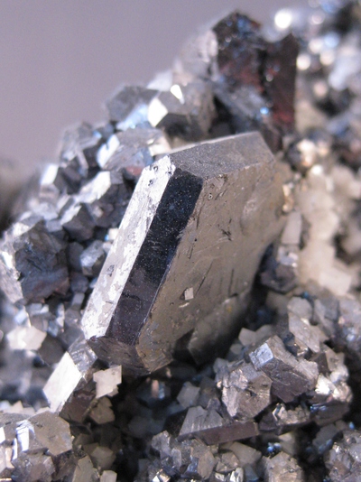


Fletcher Mine, West Fork, Reynolds County, Missouri, USA