Log InRegister
Quick Links : The Mindat ManualThe Rock H. Currier Digital LibraryMindat Newsletter [Free Download]
Home PageAbout MindatThe Mindat ManualHistory of MindatCopyright StatusWho We AreContact UsAdvertise on Mindat
Donate to MindatCorporate SponsorshipSponsor a PageSponsored PagesMindat AdvertisersAdvertise on Mindat
Learning CenterWhat is a mineral?The most common minerals on earthInformation for EducatorsMindat ArticlesThe ElementsThe Rock H. Currier Digital LibraryGeologic Time
Minerals by PropertiesMinerals by ChemistryAdvanced Locality SearchRandom MineralRandom LocalitySearch by minIDLocalities Near MeSearch ArticlesSearch GlossaryMore Search Options
Search For:
Mineral Name:
Locality Name:
Keyword(s):
 
The Mindat ManualAdd a New PhotoRate PhotosLocality Edit ReportCoordinate Completion ReportAdd Glossary Item
Mining CompaniesStatisticsUsersMineral MuseumsClubs & OrganizationsMineral Shows & EventsThe Mindat DirectoryDevice SettingsThe Mineral Quiz
Photo SearchPhoto GalleriesSearch by ColorNew Photos TodayNew Photos YesterdayMembers' Photo GalleriesPast Photo of the Day GalleryPhotography

Russell Boggs' Photo Gallery

QVR-KL3Fluorite CaF2 , Brochantite Cu4(SO4)(OH)6 , Quartz SiO2

08198290014952542691083.jpg
Sunshine No. 1 Adit, Blanchard Mine, Bingham, Hansonburg District, Socorro County, New Mexico, USA

Fluorite, Brochantite, Quartz pocket in situ. Field of view is about 1 meter across. Photo by Russell Boggs taken April 4 2009.
Copyright: © Russell Boggs      Photo ID: 484714     Uploaded by: Russell Boggs   Upload date: 2012-08-31   View Count: 332    Status: Public galleries    Type: Photo - 2560×1920 (4.9 Mpix)

Wind Mountain, New Mexico

06119540014947369573133.jpg
Wind Mountain, Cornudas Mountains, Otero County, New Mexico, USA

A view of the Wind Mountain Nepheline Syenite Lacolith from the southeast. Photo taken November 4 2008. Photo by Russell Boggs.
Copyright: © Russell Boggs      Photo ID: 484711     Uploaded by: Russell Boggs   Upload date: 2012-08-30   View Count: 1164    Status: Public galleries    Type: Photo - 2560×1920 (4.9 Mpix)

A view of a portion on the Red Marble Quarry

04094720014960963008083.jpg
Red Marble Quarry, Chewelah Mining District, Stevens County, Washington, USA

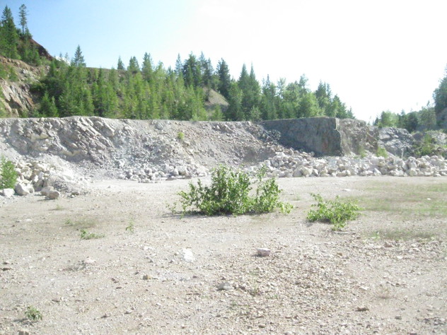
A view of a portion of the upper level of the Red Marble Quarry taken July 11 2012.
Photo ID: 484660     Uploaded by: Russell Boggs   Upload date: 2012-08-30   View Count: 481    Status: Public galleries    Type: Photo - 4000×3000 (12.0 Mpix)

HDW-ND0Magnesite MgCO3

04301790014947000569531.jpg
Red Marble Quarry, Chewelah Mining District, Stevens County, Washington, USA

Magnesite crystals from the Red Marble Quarry, Stensgar Mountain, Stevens County Washington. The specimen is about 10 cm across. The specimen was etched from dolomite matrix using dilute HCl.
Photo ID: 484622     Uploaded by: Russell Boggs   Upload date: 2012-08-30   View Count: 493    Status: Public galleries    Type: Photo - 3000×4000 (12.0 Mpix)

Me and my granddaughter Rylin

05065290014946298776827.jpg
Me and my granddaughter Rylin on the logging road above our place in Marblemount, Washington.
Photo ID: 484585     Uploaded by: Russell Boggs   Upload date: 2012-08-30   View Count: 332    Status: User gallery only    Type: Photo - 800×1021 (0.8 Mpix)
 
and/or  
Mindat Discussions Facebook Logo Instagram Logo Discord Logo
Mindat.org is an outreach project of the Hudson Institute of Mineralogy, a 501(c)(3) not-for-profit organization.
Copyright © mindat.org and the Hudson Institute of Mineralogy 1993-2024, except where stated. Most political location boundaries are © OpenStreetMap contributors. Mindat.org relies on the contributions of thousands of members and supporters. Founded in 2000 by Jolyon Ralph.
Privacy Policy - Terms & Conditions - Contact Us / DMCA issues - Report a bug/vulnerability Current server date and time: May 13, 2024 01:28:11
Go to top of page