| Classification |
|---|
|
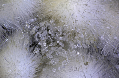
| Species: | Calcite |
| Formula: | CaCO3 |
| Confirmation |
|---|
|
| Validity: | Confirmed |
| Confirmation Methods: | Visually Identified |
| Associated Minerals Based on Photo Data: |
|---|
|
| Analcime | ⓘ8 photos of Calcite associated with Analcime at this locality. |
| Smectite Group | ⓘ5 photos of Calcite associated with Smectite Group at this locality. |
| Mordenite | ⓘ4 photos of Calcite associated with Mordenite at this locality. |
| Natrolite | ⓘ2 photos of Calcite associated with Natrolite at this locality. |
| Pyrite | ⓘ2 photos of Calcite associated with Pyrite at this locality. |
| Apophyllite Group | ⓘ1 photo of Calcite associated with Apophyllite Group at this locality. |
| Laumontite | ⓘ1 photo of Calcite associated with Laumontite at this locality. |
| Stilbite Subgroup | ⓘ1 photo of Calcite associated with Stilbite Subgroup at this locality. |
| Data |
|---|
|
| Mineral Data: | Click here to view Calcite data |
| Locality Data: | Click here to view Clinton Knob, Ryderwood, Lewis County, Washington, USA |
| Photo Gallery | View Gallery (8 photos) |
| Data Identifiers |
|---|
|
| Mindat Occurrence Record ID: | 1097026 |
| Long-form Identifier: | 1:3:1097026:7 |
| GUID (UUID V4): | 40e00bc6-7a16-4b73-a3dc-5efae8c31ae4 |
| Nearest other occurrences of Calcite |
|---|
|
|
| 8.8km (5.5 miles) | ⓘThe Half Round Roadcut, Lewis County, Washington, USA |
| 15.3km (9.5 miles) | ⓘThrash Creek, PeEll, Pacific County, Washington, USA |
| 30.8km (19.1 miles) | ⓘSilver Lake Railroad Trestle, Silver Lake, Cowlitz County, Washington, USA |
| 32.2km (20.0 miles) | ⓘMount Solo, Longview, Cowlitz County, Washington, USA |
| 32.8km (20.4 miles) | ⓘDNR Lincoln Creek Quarry, Doty Hills, Lewis County, Washington, USA |
| 34.8km (21.6 miles) | ⓘClatskanie, Columbia County, Oregon, USA |
| 37.3km (23.2 miles) | ⓘWeyerhaeuser Lincoln Creek Quarry, Doty Hills, Lewis County, Washington, USA |
| 38.9km (24.1 miles) | ⓘRainier Quarry, Rainier, Columbia County, Oregon, USA |
| 39.6km (24.6 miles) | ⓘCurved Quartz Roadcut, Altoona, Wahkiakum County, Washington, USA |
| 39.9km (24.8 miles) | ⓘB & K Quarry, Cowlitz County, Washington, USA |
| References |
|---|
|
|
| Reference Search (possible matching items) |
|---|
 | | Report (volume) | | WEWOKA FORMATION OF OKLAHOMA BY GEORGE H. GIRTY WASHINGTON GOVERNMENT PRINTING OFFICE 1915 CONTENTS....exceptional feature. The original carbonate of lime (calcite or aragonite), of which most Carboniferous fossils...Lower Coal Measures: Fort Scott, Marmaton, Bourbon County", Thayer, Olathe, Kansas City, Lawrence, Lecompton...Coal Measures: Edwardsport, Knox County, and Eugene, Vermilion County, Ind. 1900. Michelina eugenex. Beede...12,12b. Upper Coal Measures: Pomeroy, Wyandotte County, Kans. A single specimen referred to this species |
|


Clinton Knob, Ryderwood, Lewis County, Washington, USA