APPLE iPod touch used with mindat.org
Mindat.org contributors over the years have used a large number of different camera and scanning devices to create the images now shared within the site. Here is information on this particular device and examples of the images created with it.

| Vendor | APPLE |
|---|---|
| Model | iPod touch |
| Type: | Other |
| Year of Introduction: | 2010 |
| Resolution: | 0.7 mpix |
The Southern View of the Afterthought Mine Ruins
Afterthought Mine, Ingot, East Shasta Copper - Zinc Mining District, Klamath Mountains, Shasta County, California, USA

Middle View of the Sulphur Bank Mine
Sulphur Bank Mine, Clear Lake Oaks, Sulphur Creek Mining District, Lake County, California, USA

Northern Ruins of Afterthought Mine at Ingot
Afterthought Mine, Ingot, East Shasta Copper - Zinc Mining District, Klamath Mountains, Shasta County, California, USA

Metavolcanic Blueschist Outcrop
Laytonville Quarry, Laytonville, Coastal Range, Mendocino County, California, USA

Lower Blueschist Volcanics
Laytonville Quarry, Laytonville, Coastal Range, Mendocino County, California, USA

Fluorite, Pyrite, Calcite
Foucault Quarry, Brownsburg-Chatham, Argenteuil RCM, Laurentides, Québec, Canada

East View of the Sulphur Bank Mine
Sulphur Bank Mine, Clear Lake Oaks, Sulphur Creek Mining District, Lake County, California, USA

Overview of the Sulphur Bank Mine
Sulphur Bank Mine, Clear Lake Oaks, Sulphur Creek Mining District, Lake County, California, USA

Middle Photo of the Afterthought Mine Ruins
Afterthought Mine, Ingot, East Shasta Copper - Zinc Mining District, Klamath Mountains, Shasta County, California, USA

Dunite Rocks near Ehorn Group
Ehorn group, Franklin Point, Coastal Range, Tehama County, California, USA

Close-up view
Soca Quarry, Stukely-sud, Memphrémagog RCM, Estrie, Québec, Canada

Talc, Malachite
Ganim Mine, Whiskeytown, Whiskeytown Mining District, Klamath Mountains, Shasta County, California, USA

Impassible Underbrush Above Grau Pit
West pit, Grau Mine, North Elder Creek group, Tehama County, California, USA

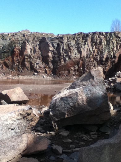
The West wall
Foucault Quarry, Brownsburg-Chatham, Argenteuil RCM, Laurentides, Québec, Canada
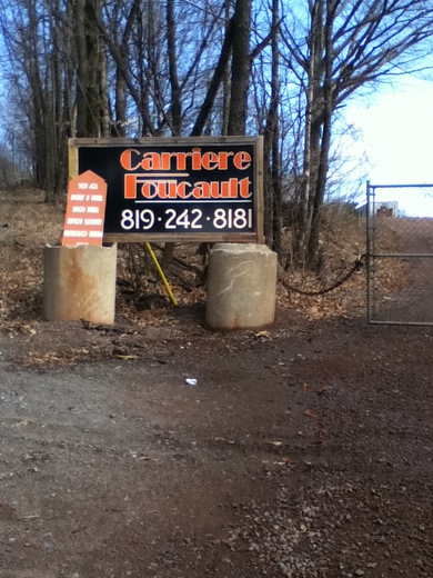
Quarry entrance
Foucault Quarry, Brownsburg-Chatham, Argenteuil RCM, Laurentides, Québec, Canada
Western End of Tailings Pile of Ganim Mine
Ganim Mine, Whiskeytown, Whiskeytown Mining District, Klamath Mountains, Shasta County, California, USA

Looking South
Soca Quarry, Stukely-sud, Memphrémagog RCM, Estrie, Québec, Canada

Vue vers le nord-est - Northeast-facing view
Saint-François quarry, Saint-Germain-de-Grantham, Drummond RCM, Centre-du-Québec, Québec, Canada

Fallen Block of Eclogite
Syke Rock, State route 162, Longvale, Coastal Range, Mendocino County, California, USA

Deerite - Howieite Rich Boulder
Laytonville Quarry, Laytonville, Coastal Range, Mendocino County, California, USA

Another View of Rich Deerite - Howieite Exposure
Laytonville Quarry, Laytonville, Coastal Range, Mendocino County, California, USA

Eastern Face of Talings Pile
Ganim Mine, Whiskeytown, Whiskeytown Mining District, Klamath Mountains, Shasta County, California, USA

Franciscan Formation Outcrop
Elder Creek, Los Molinos, Tehama County, California, USA

Fault Contact Between Metavolcanics and Metasediments
Laytonville Quarry, Laytonville, Coastal Range, Mendocino County, California, USA

Old Foundations of Ganim Mine
Ganim Mine, Whiskeytown, Whiskeytown Mining District, Klamath Mountains, Shasta County, California, USA

Downward Looking View Above Grau Pit
West pit, Grau Mine, North Elder Creek group, Tehama County, California, USA

View of Syke Rock
Syke Rock, State route 162, Longvale, Coastal Range, Mendocino County, California, USA

Another View of the Fault
Laytonville Quarry, Laytonville, Coastal Range, Mendocino County, California, USA

Upward View of Trail Above Grau Pit
West pit, Grau Mine, North Elder Creek group, Tehama County, California, USA

Upclose View of Fault Contact
Laytonville Quarry, Laytonville, Coastal Range, Mendocino County, California, USA

Syke Rock at highway
Syke Rock, State route 162, Longvale, Coastal Range, Mendocino County, California, USA

Upper Bank of Laytonville Quarry
Laytonville Quarry, Laytonville, Coastal Range, Mendocino County, California, USA

One of the Exploration Pits of the Ehorn Group
Ehorn group, Franklin Point, Coastal Range, Tehama County, California, USA

Middle section of Syke Rock
Syke Rock, State route 162, Longvale, Coastal Range, Mendocino County, California, USA

Upper Quarry Wall
Laytonville Quarry, Laytonville, Coastal Range, Mendocino County, California, USA

Right side end of Syke Rock
Syke Rock, State route 162, Longvale, Coastal Range, Mendocino County, California, USA

South End of Upper Quarry Wall
Laytonville Quarry, Laytonville, Coastal Range, Mendocino County, California, USA

Chlorite Group Block
Syke Rock, State route 162, Longvale, Coastal Range, Mendocino County, California, USA

Panoramic view on Monchegorsk's suburbs from Nittis Mountain
Monchegorsk, Murmansk Oblast, Russia

West View of the Sulphur Bank Mine
Sulphur Bank Mine, Clear Lake Oaks, Sulphur Creek Mining District, Lake County, California, USA

kenai lake

Calcite
Canal dump, Niagara Falls, Niagara Region, Ontario, Canada

No more matching photos found.


