Log InRegister
Search For:
Mineral Name:
Locality Name:
Keyword(s):
 
Home PageAbout MindatThe Mindat ManualHistory of MindatCopyright StatusWho We AreOur ScienceMindat Newsletter [Free Download]Contact Us
Donate to MindatSponsor a PageCorporate SponsorshipSponsored Pages
Learning CenterWhat Is a Mineral?The Most Common Minerals on EarthInformation for EducatorsMindat ArticlesMindat Newsletter [Free Download]The ElementsThe Mineral Quiz
Search FormMinerals by PropertiesMinerals by ChemistryMineral Visual ExplorerAdvanced Locality SearchRandom MineralRandom LocalitySearch by minIDMinerals by CountryAlphabetical Mineral IndexAlphabetical Locality SearchMineral Association SearchList of CountriesLocalities Near MePhoto SearchSearch ArticlesSearch GlossaryThe Rock H. Currier Digital LibraryMore Search Options
The Mindat ManualAdd a New PhotoRate PhotosLocality Edit ReportCoordinate Completion ReportAdd Glossary Item
MineralsPetrologyAlkaline & Carbonatite DatabaseFossilsMeteoritesGeologic TimeEarth through Time
Mining CompaniesStatisticsMineral MuseumsClubs & OrganizationsMineral Shows & EventsDevice SettingsTime Machine
Read DiscussionsIdentification Request
Photo SearchPhoto GalleriesSearch by ColourPhoto Colour ExplorerNew Photos TodayNew Photos YesterdayMembers' Photo GalleriesPast Photo of the Day GalleryPhotography

Ploieşti, Municipiul Ploieşti, Prahova, Romania


Alternative Names:Ploeshh, Ploesti, Ploeszti, Ploeşti, Ploiesti, Ploieşti, Ploiești, plwyst, plwysty, Плоещ, פלוישט, פלוישטי
Type:Seat of a first-order administrative division - seat of a first-order administrative division (PPLC takes precedence over PPLA)
Mindat.org Region:Prahova County, Romania
Region:Municipiul Ploieşti, Prahova, Romania
Latitude:44° 57' 0" N
Longitude:26° 1' 0" E
Lat/Long (dec):44.95,26.01667
Köppen climate type:Cfa : Humid subtropical climate
Population:228,851 (2016)
Mindat Feature ID:670474
Long-form Identifier:mindat:2:6:670474:2
GUID:0
  Search for other features

Mindat.org localities near to this feature


LocalityLatitudeLongitudeDistanceBearing
Ploieşti, Prahova County, Romania44° 56' 45" N26° 1' 23" E0.7km (0.4 miles)
Rafinǎria Vega Ploieşti, Ploieşti, Prahova County, Romania44° 57' 56" N26° 1' 31" E1.9km (1.2 miles)
Rafinǎria Astra Română, Ploieşti, Prahova County, Romania44° 55' 12" N26° 1' 34" E3.4km (2.1 miles)
Rafinǎria Petrobrazi, Ploieşti, Prahova County, Romania44° 52' 28" N26° 0' 29" E8.4km (5.2 miles)
Buştenari oil field, Comuna Telega, Prahova County, Romania45° 8' 34" N25° 49' 58" E25.8km (16.1 miles)
Doftana salt mine, Prahova County, Romania45° 8' 30" N25° 46' 30" E28.6km (17.7 miles)
Moreni oil field, Dâmbovița County, Romania44° 59' 6" N25° 39' 18" E28.7km (17.8 miles)
Câmpina oil field, Prahova County, Romania45° 7' 32" N25° 43' 26" E30.2km (18.8 miles)
Slănic Salt Mine, Prahova County, Romania45° 14' 9" N25° 56' 30" E32.3km (20.1 miles)
Gura-Ocniţei oil field, Dâmbovița County, Romania44° 56' 43" N25° 33' 55" E35.5km (22.1 miles)
Ochiuri, Gura-Ocniţei oil field, Dâmbovița County, Romania44° 58' 0" N25° 32' 38" E37.2km (23.1 miles)
Mount Leaota, Stoenești, Argeş County, Romania45° 19' 23" N25° 18' 53" E68.9km (42.8 miles)
Timișu de Sus, Predeal, Brașov County, Romania45° 31' 46" N25° 34' 39" E73.0km (45.4 miles)
Valea lui Negulet, Stoenești, Argeş County, Romania45° 16' 23" N25° 11' 38" E73.9km (45.9 miles)
Meledic Karst Plateau, Mânzăleşti, Buzău County, Romania45° 29' 49" N26° 37' 9" E77.0km (47.8 miles)
Blejeşti, Teleorman County, Romania44° 17' 40" N25° 28' 20" E84.7km (52.6 miles)
Árkos, Covasna County, Romania45° 53' 58" N25° 45' 59" E107.4km (66.7 miles)
Cathedral of Curtea de Argeș, Curtea de Argeș, Argeş County, Romania45° 9' 24" N24° 40' 31" E107.8km (67.0 miles)
Málnás, Covasna County, Romania46° 0' 29" N25° 50' 36" E118.5km (73.6 miles)
Făgăraș Mountains, Sibiu County, Romania45° 34' 59" N24° 45' 0" E121.6km (75.6 miles)
Gresia meteorite, Gresia, Teleorman County, Romania44° 10' 17" N24° 55' 8" E122.7km (76.3 miles)
Bogata Olteană quarries, Hoghiz, Brașov County, Romania45° 57' 15" N25° 21' 27" E122.9km (76.4 miles)
Cuciulata quarry, Hoghiz, Brașov County, Romania45° 56' 49" N25° 17' 28" E124.5km (77.3 miles)
Perșani Mountains occurrences, Brașov County, Romania45° 58' 0" N25° 19' 0" E125.5km (78.0 miles)
Capeni, Baraolt, Covasna County, Romania46° 2' 23" N25° 34' 41" E125.9km (78.2 miles)
Racoş, Racoş (Racoşul de Jos), Brașov County, Romania46° 1' 26" N25° 24' 34" E128.4km (79.8 miles)
Băile Bálványos, Turia, Covasna County, Romania46° 6' 31" N25° 57' 22" E128.9km (80.1 miles)
Turia Cave, Băile Bálványos, Turia, Covasna County, Romania46° 7' 11" N25° 56' 54" E130.2km (80.9 miles)
Racoşul de Sus, Baraolt, Covasna County, Romania46° 4' 49" N25° 32' 53" E130.9km (81.3 miles)
Magyarhermány (Herculian), Covasna County, Romania46° 8' 7" N25° 42' 29" E134.0km (83.2 miles)
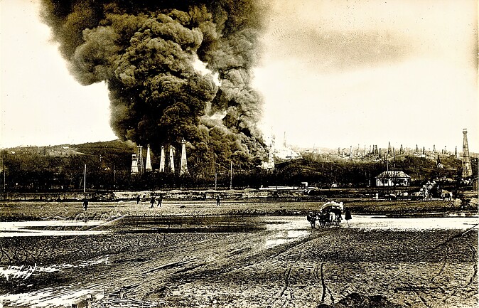
02452000017272426454777.jpg
View of the Ploieşti oil field, ca. 1930.

Ploieşti, Prahova County, Romania
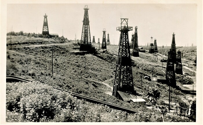
02855220017272426461380.jpg
View of the Ploieşti oil field, in 1937.

Ploieşti, Prahova County, Romania
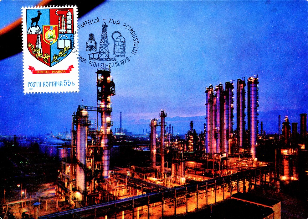
03430470017272426454746.jpg
View of the Ploieşti oil field, in 1979.

Rafinǎria Petrobrazi, Ploieşti, Prahova County, Romania
02452000017272426454777.jpg
View of the Ploieşti oil field, ca. 1930.

Ploieşti, Prahova County, Romania
02855220017272426461380.jpg
View of the Ploieşti oil field, in 1937.

Ploieşti, Prahova County, Romania
04703460017272426498481.jpg
View of the Ploieşti oil field, in 1979.

Rafinǎria Petrobrazi, Ploieşti, Prahova County, Romania
02452000017272426454777.jpg
View of the Ploieşti oil field, ca. 1930.

Ploieşti, Prahova County, Romania
02855220017272426461380.jpg
View of the Ploieşti oil field, in 1937.

Ploieşti, Prahova County, Romania

Regions in mindat.org that contain this locality

RegionType
Eurasian PlateTectonic Plate
Moesian Platform, Eurasian PlateCraton
EuropeContinent
Carpathian Mountains, EuropeMountain Range
RomaniaCountry
Prahova County, RomaniaCounty

Regions in GADM Database

RegionGADM number
Romania, Prahova, Ploiesti187.32.2182.0.0.0
 
and/or  
Mindat.org® is an outreach project of the Hudson Institute of Mineralogy, a 501(c)(3) not-for-profit organization. Mindat® and mindat.org® are registered trademarks of the Hudson Institute of Mineralogy.
Copyright © mindat.org and the Hudson Institute of Mineralogy 1993-2026, except where stated. Most political location boundaries are © OpenStreetMap contributors. Mindat.org relies on the contributions of thousands of members and supporters. Founded in 2000 by Jolyon Ralph and Ida Chau.
Content on this site may not be used to train, fine-tune, or otherwise develop artificial intelligence or machine learning models without prior written permission - see our Terms & Conditions.
To cite: Ralph, J., Von Bargen, D., Martynov, P., Zhang, J., Que, X., Prabhu, A., Morrison, S. M., Li, W., Chen, W., & Ma, X. (2025). Mindat.org: The open access mineralogy database to accelerate data-intensive geoscience research. American Mineralogist, 110(6), 833–844. doi:10.2138/am-2024-9486.
Privacy Policy - Terms & Conditions - Contact Us / DMCA issues - Report a bug/vulnerability Current server date and time: November 9, 2026 11:49:08
Go to top of page