 | | Journal (article/letter/editorial) | | Postcard view of the Waukon iron mine, Allamakee County, cia. 1912. John Taylor collection. ARTHUR E ...Unfortunately. with today’s environmental laws and mine and quarry regulations. the prolific collecting of the 1950s...HAROLD L. PRlOR P.O. Box 111 Columbus Junction, Iowa 52738 halprior@ louisacomm.net When we began this...too, could be cited with many other localities. Iowa contains the type locality for one mineral, iowaite...December 2014 Figure 2. Map of Iowa showing the counties. Courtesy Iowa Geological Survey. ACKNOWLEDGMENTS | 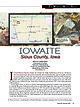 | | Journal (article/letter/editorial) | | Figure 1. The state of Iowa map; prepared by William Besse. IOW AITE Sioux County, Iowa BRUCE CAIRNCROSS ...1,000–1,500 feet below the surface in Sioux County, Iowa (Kohls and Rodda 1967); approximately thirty-five...of Johannesburg. Volume 93, May/June 2018 271 Iowa has 74 valid species (Mindat.org; accessed March...geodes from the Keokuk area in Lee County (Wherry 1918; Smith 1997; Huizing 2017). The Keokuk geode is also...also the official state rock for Iowa. Pint’s quarry in Black Hawk County has produced collectible, attractive |  | | Book (volume) | | Dahlonega Co. and Rabum Co., and the McDuffie County Belt extending through portions of McDuffie, Warren...Sphalerite. BALDWIN COUNTY MILLEDGEVILLE, at state farmjasper. BANKS COUNTY COMMERCE, along Hwy. 59...along adjoining Co. linerock crystal. BARROW COUNTY WINDER, along rd. to Jefferson and 1½ mi. inside...Guide for Rock Hounds in the United States BARTOW COUNTY AREA, Saltpeter Cave, as floatjasper. CARTERSVILLE:...(banded, various colors), jasper. BIBB COUNTY MACON: at Holton Quarry, 7½ mi. NWagate; N of Calloway |  | | Book (volume) | | these coal seams the collector may often find Marcasite and Pyrite. The measures are 1,200 to 1,400 feet...600 to 800 feet thick in the north. ALEXANDER COUNTY FAYVILLE, area stream gravels⎯agate, jasper, rare...⎯agate, jasper; d RR siding of Clay⎯agate. CALHOUN COUNTY AREA, shores of the Mississippi R., in the Warsaw...crystals). CRAWFORD COUNTY PALESTINE, area deposits⎯Siderite. EDWARDS COUNTY AREA, T. 1 S, R. 10 E...E, regional deposits⎯Siderite. FULTON COUNTY FARMINGTON, W 6 mi. on Rte. 116 to the Rapatee No. 5 strip |  | | Book (volume) | | these coal seams the collector may often find Marcasite and Pyrite. The measures are 1,200 to 1,400 feet...600 to 800 feet thick in the north. ALEXANDER COUNTY FAYVILLE, area stream gravels⎯agate, jasper, rare...⎯agate, jasper; d RR siding of Clay⎯agate. CALHOUN COUNTY AREA, shores of the Mississippi R., in the Warsaw...crystals). CRAWFORD COUNTY PALESTINE, area deposits⎯Siderite. EDWARDS COUNTY AREA, T. 1 S, R. 10 E...E, regional deposits⎯Siderite. FULTON COUNTY FARMINGTON, W 6 mi. on Rte. 116 to the Rapatee No. 5 strip |  | | Journal (issue) | | Vice-President (MFMGS) 2813 Patricia Dri ve, Des Moines, Iowa 50322 M rs . W. R. Anderson , Secretary (RMFMS)...Beverly Dickerson ................... 26 Iowa's Kaser Quarry by Paul L. Broughton .........................Kate Steinbrenner, 2813 Patricia Or., Des Moines, Iowa 50322. For coordination of regional Federation shows...98371. Dealers; field trips. July 7 thru 9 . Oxford County M ineral and Gem Association , sponsor. 11th Annual...Tangerine, $73.40 each postpaid to any place in the USA. For your Cinnabar, Galena, Cerussite, Quartz samples |  | | Report (issue) | | part of Marion County, Missouri: unpublished Masters thesis, Univ. of Iowa, Iowa City, Iowa, 1966. American...and origin of sulfa-saline ground water, Saline County, Missouri, in Annual report, Water Resources Research...of Highway 21 in Jefferson County as a scenic highway: Jefferson County Planning and Zoning Comm.,...of Highway 21 in Jefferson County as a scenic highway: Jefferson County Planning and Zoning Comm., pp...the City of St. Louis and the adjacent St. Louis County, Missouri (abstract): Dissert . Abs., vol. 26 |  | | Book (volume) | | Virginia VOLUME 3: THE NORTHWESTERN QUANDRANT Idaho, Iowa, Kansas, Minnesota, Missouri, Montana, Nebraska...TREASURES VOLUME ep The Northwestern Quadrant Idaho, Iowa, Kansas, Minnesota, Missouri, Montana, Nebraska...volumes, through very precise directions and accurate county maps, to get you to the best and most accessible...for the county in which it is located. This site number also appears under the given county in the text...(in soil, matrix, road cut, pegmatite, shoreline, quarry, gravel pit, prospect, mine, etc.). Let’s take |  | | Journal (article/letter/editorial) | | mine and, from 1973, from several shaft mines (Kaser, 1983). The city of Zarafshan was established during...chalcopyrite, pyrrhotite, sphalerite, galena, marcasite, gold, and bismuthinite occur less widely in this...chlorite, hydromica, and pyrite occur more rarely. Marcasite, arsenopyrite, sphalerite, chalcopyrite, fahlore...minerals), no. 3: Kiev, Naukova dumka, p. 91-101. Kaser, Michael, 1983, The Soviet gold-mining industry |  | | Journal (article/letter/editorial) | | Houston, Texas 77058, USA 2 NASA Postdoctoral Program, Oak Ridge, Tennessee 37830, USA 3 Lunar and Planetary...Arizona 85712, USA 4 Naval Research Laboratory, Washington, District of Columbia 20375, USA 5 NASA Johnson...Johnson Space Center, Houston, Texas 77058, USA *Corresponding author. E-mail: eve.l.berger@nasa.gov (Received...low-temperature parent body environment (MacKinnon and Kaser 1990; Berger et al. 2011). Phase diagram analysis...meteorites. Science 197:561–562. MacKinnon I. D. R. and Kaser S. A. 1990. Trace phases in CI chondrites Alais |  | | Book | | MineralogicalRecord.com I IIMORIITE-(Y) EUROPE FRANCE Trimouns quarry, Luzenac, Ariege. Operated for talc since the beginning...beginning of the 20th century, the Trimouns quarry became well known to collectors around 1990 for the...long (Marty, 2004 ). AFRICA widely in Litchfield County, where good crystals were taken from quartz veins...region (Brunet, I 977b ). NEW YORK Amity, Orange County. At many isolated collected sites between the towns...Litchfield County. Ilmenite masses and crystals from somewhere near Washington, Litchfield County, were described |  | Feitzinger, G., Paar, W. H., Tarkian, M., Reche, R., Weinzierl, O., Prochaska, W., Holzer, H. (1995) Vein type Ag-(Au)-Pb, Zn, Cu-(W,Sn) mineralization in the Southern Kreuzeck Mountains, Carinthia Province, Austria. Mineralogy and Petrology, 53 (4) 307-332 doi:10.1007/bf01160154 | Journal (article/letter/editorial) | | mineralization is found in the deposits Strieden, Kaser Wiesel, Politzberg, etc. (Reimann, 1980; Gould,...of ore is dominantly composed of pyrrhotite (+ marcasite), pyrite, arsenopyrite (especially at the Carolus...(2) Arsenopyrite Ullmannite Pyrite Pyrrhotite Marcasite • x • • C) Ferberite Scheelite Molybdenite Rutile |  | | Book | | HfiRIN COUNTY FREE LIBRfiRY 311110G386652Q I V Russell P MacFal A COLOR TREASUF FOR COLLECTORS...are 100 maps geared to leading the "hunter to his quarry" and more than eighty photographs of minerals in...to Hunting Locations ? i 9 GIVEN TO THE MARIN COUNTY LIBRARY BY MARI N L MTNF.RAT. SOCTETY DAVID...knapsack you can use a mountaineering bag or a mili- quarry or mine where a permit tary bag; make it it...may be able to buy specimens. map of Keweenaw County. Mich- Part of the U.S. Geological Survey topographic |  | | Journal (issue) | | President (~FMGS) 2813 Patricia Drive, Dea Moines, Iowa 50322 Mrs. G. E. Lee, Vice-President (NFMS) 704...Katie Steinbrenner, 2813 Patricia Dr.. Des Moines. Iowa 50322. For coordination of regional Federation shows...Show. " Stanislaus Treasure Trove." Stanislaus County Fairgrounds, Turlock, Ca. Mother Lode M ineral...$2 regardless of the size of your order for all USA orders! NEW CUTTING ROUGH MATERIAL. AUSTRALIAN BLUE...Jasper " Turitella" Agate •coquimbite Sunstone Marcasite Chrysocolla Carrara " Marble" Jadeite Indian Moss | | | Book | | 100 maps geared to leading the " hunter to his quarry" and more than eighty photographs of minerals in...easier for you If you plan to vIsIt an operating quarry or mine where a permll Is required make the necessary...topographic map of the Delaware q uadrangle o f Keweenaw County, Michigan This ,s an example o f the more picturesque...be discovered by locating the porous layers In a quarry or other exposure and following them along the...rich mines rn Arrzona and Montana 7 - (Left) Quarry 1n Val di Serra, Trenhno, Italy. On the front of |  | | Book (edition) | | MARIN COUNTY FREE LIBRARY 3 1111 00289 4184 \ I s Fifth Revised Edition A complete, state-by-state...a Jersey's Limecrest quarry, for instance, is open to a year; the Foote quarry in North Carolina one...another is thirty-five miles southeast of Des Moines, Iowa, near Knoxville. It is reasonable to take the weather...or goggles, and safety-toe shoes in an operating quarry or mine. They are prudent precautions against disaster...trespassers or even fenced in some states. Mine and quarry owners are often reluctant to give permission for |  | | Report (Issue volume) | | State mineral production and mineral production by county were prepared in the Division of Statistics and...Resources. Iowa: Geological Survey Bureau, Division of Energy and Geological Resources, Iowa Department.... . . . . . . . . . . . . . . . . . . . . . 187 Iowa, by Donald K. Harrison and Robert M. McKay . . ...this report. Name State____________ SECTION 2. County _ __ _ _ _ _ _ _ _ __ Stocks. production, end...sand and gravel (consrruction), stone (dimension). Iowa 316,370 32 .95 Cement (portland), stone (crushed |  | | Book (volume) | | Colorado; colorless scheelite (19.66 ct), Kern County, California; octagonal step cut violetish pink...Vivid blue matched benitoite gems from San Benito County, California, consisting of 52 benitoites and 75...Cantlin, Ellis, [D; Jeannette B. Carillo, Gem Center USA, EI Paso, TX; Gary Christopher, The Prospectors Cache...Resources, Vancouver, BC; Barbara L. Muntyan, Ouray County Historical Society, Ouray, CO; Merrill O. Murphy...sne-aseseeateeCounty, Can tess ccraccacaerscsascn enaeantsrse Figure |  | | Report (volume) | | 11 Los Angeles County Mus. Quart.; Science Ser. [Paleontology Pub.] Los Angeles County Museum Quarterly;...Herbert, Jr. Ground-water resources of Liberty County, Texas : TJ. S. Geol. Survey, WaterSupply Paper...of some gold-base metal veins in eastern Grant County, Oregon [abs.] : Econ. Geology, v. 45, no. 4, p...Mineralization in the Volcano district, Elmore County, Idaho [abs.] : Geol. Soc. Ain. Bull., v. 61, no...resources of Bristol, Warren and Barrington, Bristol County, Rhode Island : B. I. Port Indus. r>ev. Comm., |  | | Report (volume) | | H1ldebrand, Fred A, Havens, R G Thalemte from Teller County, Colorado, zn Geolog1cal Survey Research 1962 U...Precambnan(?) and Cambnan stratigraphy m Esmeralda County, Nevada, m Geolog1cal Survey Research 1962 US Geol...data on the Chmax stock, Nevada Test S1te, Nye County, Nevada Geophystcs, v 27, no 5, p 599-610, tllus...Prehmtnary report on Cathenne Lake area, Chtcoutimt County [also French edttwn] Quebec Dept Nat Resources...Douglas A. Sand and gravel resources of McHenry County, IlhnOis Ilhnois Geol Survey Cue 336, 15 p , all | | | Book (volume) | | Vivid blue matched benitoite gems from Sai, Benito County, California, consisting of 52 benitoites and 75...Cantlin, Ellis, ID; Jeannette B. Carillo, Gen1 Center USA, El Paso, TX; Gary Christopher, The Prospectors Cache...Resources, Vancouver, BC; Barbara L. Muntyan, Ouray County Historical Society, Ouray, CO; Merrill 0. Murphy... 15 Figure 6. Dallas Gem Mine in San Benito County, CA..............................................Benitoite recovery from alluvial deposits, San Benito County, CA ................ 29 Figure 8. Title page |  | | Report (volume) | | Fatrvtew Valley, and Fourmtle Flat, Churchtll County, Nevada US Atomtc Energy Comm Rept VUF-1001, p...Jr., Szabo, M W Mmeral resources map of Barbour County, Alabama Alabama Geol Survey Map 32, scale about...Stewart, John H Preltmtnary geologic map of Esmeralda County Nevada US Geol Survey Mtneral lnv Fteld Studtes...Jr Geology of the Sterra Blanca area, Hudspeth County, Texas US Geol Survey Prof Paper 479, 131 p, tllus...trask1te, verplanck1te and mulflte from Fresno County, California Am Mmeralogist, v 50, no 9, p 1500-1503 |  | | Report (volume) | | Commission Iowa Acad. Sci. Proc. - Proceedings of the Iowa Academy of Sciences. of Northern Iowa. Cedar Falls...Falls, Iowa. Iowa Geol. Survey Rept. Inv. City, Iowa. Gesamten University Iowa Geological Survey Report...Investigations. Iowa Iowa State Univ. Dept. Earth Sci. Pub. Sciences Publication. Ames, Iowa. Iowa State University...Earth Iowa Univ. Studies Nat. History- The University of Iowa Studies in Natural History. Iowa City,... Iowa. Irish Naturalists' Jour. - The Irish Naturalists' Journal. Committee. Belfast, Northern Ireland |  | | Report (volume) | | Geology California Div. Mines and Geology County Rept. Geology County Report. San Francisco, Calif. California...Interstate Oil Compact Commission Iowa Geol. Survey Rept. Inv. City, Iowa. Iowa Geological Survey Report of...Investigations. Iowa Iowa Univ. Studies Nat. History- The University of Iowa Studies in Natural History. Iowa City...City, Iowa. Isis- Isis. Official quarterly journal of the History of Science Society. Seattle, Wash. Italia...Conservation. Conservation Society of America. Ankeny, Iowa. Soil Jour. Soil Sci.- Journal of Soil Science |  | | Report (volume) | | Alvarez, M., Jr.,6. Mountain-building, chronology, Iowa, ground water, geologic reand nature of geologic...described. Div. Mines, 1; Jenkins, O. P., Choctaw County, Highway 17 area: 3. Toulmin, L. D., Jr., 3. Minor:...analysis: KelH. D., 5. ler, W. D., 3. Talladega County, hematiteOklahoma, potash agstone, granite magnetite...ground water: Powham, C. E. ell, W. J., 4. Marengo County: Newton, J. G., 1. Core-drilling program, ChattanooMica:...J.,4. Excursion, Tertiary type-localiMontgomery County: Reade, ties: Rainwater, E. H. , 1. H. L. , Jr |
|


