| Locality type: | Glacier |
| Classification |
|---|
|
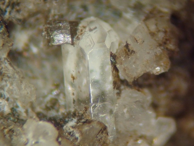
| Species: | 'Apatite' (not an IMA approved species) |
| Formula: | Ca5(PO4)3(Cl/F/OH) |
| Confirmation |
|---|
|
| Validity: | Believed Valid |
| Data |
|---|
|
| Mineral Data: | Click here to view Apatite data |
| Locality Data: | Click here to view Stampfl glacier, Finkenberg, Schwaz District, Tyrol, Austria |
| Photo Gallery | View Gallery (2 photos) |
| Data Identifiers |
|---|
|
| Mindat Occurrence Record ID: | 505038 |
| Long-form Identifier: | 1:3:505038:3 |
| GUID (UUID V4): | 5f4da65b-3c28-4080-bd11-06021fbfdc9c |
| Nearest other occurrences of Apatite |
|---|
|
|
| 1.0km (0.6 miles) | ⓘGrawandkofel (Croda Alta), Vizze Pass (Pfitsch Pass; Pfitscher Joch), Sankt Jakob (San Giacomo), Pfitsch (Val di Vizze), Wipptal (Alta Vall'Isarco), South Tyrol, Trentino-Alto Adige (Trentino-South Tyrol), Italy |
| 1.5km (0.9 miles) | ⓘWasserfallköpfe, Vizze Pass (Pfitsch Pass; Pfitscher Joch), Sankt Jakob (San Giacomo), Pfitsch (Val di Vizze), Wipptal (Alta Vall'Isarco), South Tyrol, Trentino-Alto Adige (Trentino-South Tyrol), Italy |
| 2.1km (1.3 miles) | ⓘWindtal, Vizze Pass (Pfitsch Pass; Pfitscher Joch), Sankt Jakob (San Giacomo), Pfitsch (Val di Vizze), Wipptal (Alta Vall'Isarco), South Tyrol, Trentino-Alto Adige (Trentino-South Tyrol), Italy |
| 3.7km (2.3 miles) | ⓘCroda Rossa southwest slope (Rotbachl peak southwest slope), Vizze Pass (Pfitsch Pass; Pfitscher Joch), Sankt Jakob (San Giacomo), Pfitsch (Val di Vizze), Wipptal (Alta Vall'Isarco), South Tyrol, Trentino-Alto Adige (Trentino-South Tyrol), Italy |
| 5.6km (3.5 miles) | ⓘGriesferner glacier (Griesferner; Grießferner), Oberbergtal, Sankt Jakob (San Giacomo), Pfitsch (Val di Vizze), Wipptal (Alta Vall'Isarco), South Tyrol, Trentino-Alto Adige (Trentino-South Tyrol), Italy |
| 5.7km (3.5 miles) | ⓘGliedergang, Unterbergtal, Sankt Jakob (San Giacomo), Pfitsch (Val di Vizze), Wipptal (Alta Vall'Isarco), South Tyrol, Trentino-Alto Adige (Trentino-South Tyrol), Italy |
| 6.0km (3.7 miles) | ⓘOberberg (Sopramonte), Oberbergtal, Sankt Jakob (San Giacomo), Pfitsch (Val di Vizze), Wipptal (Alta Vall'Isarco), South Tyrol, Trentino-Alto Adige (Trentino-South Tyrol), Italy |
| 7.7km (4.8 miles) | ⓘHochfeiler (Gran Pilastro), Unterbergtal, Sankt Jakob (San Giacomo), Pfitsch (Val di Vizze), Wipptal (Alta Vall'Isarco), South Tyrol, Trentino-Alto Adige (Trentino-South Tyrol), Italy |
| 7.8km (4.9 miles) | ⓘGliederferner glacier (Hochfeilerhütte; Rifugio Gran Pilastro; Rifugio Città di Monza; Wiener Hütte), Unterbergtal, Sankt Jakob (San Giacomo), Pfitsch (Val di Vizze), Wipptal (Alta Vall'Isarco), South Tyrol, Trentino-Alto Adige (Trentino-South Tyrol), Italy |
| 8.2km (5.1 miles) | ⓘGrabspitze (Cima Grava) East Slope, Pfunders Valley (Fundres Valley), Vintl (Vandoies), Puster Valley District, South Tyrol, Trentino-Alto Adige (Trentino-South Tyrol), Italy |
| References |
|---|
|
|


Stampfl glacier, Finkenberg, Schwaz District, Tyrol, Austria