 | | Report (issue) |
| FOR THE OPHIR AND MERCUR 7 1/2-MINUTE QUADRANGLES, UTAH By Edwin W. looker 1 Open-File Report 87-152 ...thrust fault in the Ophir and Mercur quadrangles, Utah....... Figure 2. Generalized stratigraphic section...FOR THE OPHIR AND MERCUR 7 1/2-MINUTE QUADRANGLES, UTAH By Edwin W. looker INTRODUCTION The adjoining Ophir...north-central Utah, and include the Ophir and Mercur mining districts and the neighboring Sunshine (South Mercur)...Mercur) and West Mercur mining areas. The Mercur district, closed since the 1940's, was reactivated in |
 | | Report (issue) |
| Mineral Deposits of MOUNT DIABLO Contra Costa County, California rUNlVERSlTY OF CAUFORN DAVIS View...Mineral Deposits of MOUNT DIABLO Contra Costa County, California By EARL H. PAMPEYAN, U.S. Geological...deposits 24 Ryne mine 25 Mount Diablo mine 26 Prospects 26 Prospect near Sunshine 26 27 in Perkins...Perkins Canyon Outlook 27 Copper 28 Gold and 28 Chromite 28 Manganese 28 Asbestos 28 Crushed...Camp Origin silver «• Company Company Bradley Mining 28 H. 28 Mount Diablo Rock and Aggregates Company |
 | | Book (volume) |
| ............................................452 Utah .................................................................548 Table of Maps Page Alabama County Map ...................................................................................4 Alaska County and Stream Map ..................................Co. Mining Districts ............................................................22 Arizona County Map.........................23 Arizona – Cochise Co. Mining Districts .................................... |
 | | Book |
| Island South Carolina South Dakota Tennessee Texas Utah Vermont Virginia Washington West Virginia Wisconsin...of commercial mining is also long, beginning with the Kenya opal mines of 4000 B.C. Mining began with gemstones...gemstones, instead of metallic ores, and mining for turquoise was enormously extended throughout the...had been sending great expeditions to prospect and mine for it throughout the Sinai Peninsula since at least...and abandoned, one is also sure to find extensive mine dumps sloping steeply down from the shaft or tunnel |
 | | Book (volume) |
| ............................................387 Utah...................................................rights, so remember you were told. If in doubt, a county map will tell you who the legal owner is. Good...gemmy qualities for cutting and polishing. AUTAUGA COUNTY PRATTVILLE, N. 6 mi., and just E of the Birmingham...were well known to prehistoric Indians.) BARBOUR COUNTY BAKER HILL, SE 1 mi. : 1 in a deep ravine, as a...deep red to variegated⎯ocher. BIBB COUNTY GENERAL AREA: c county gravel pits along the Cahaba R.⎯gemmy |
 | | Book |
| chemical properties . Uses and marketing grades. . . . Mining and beneficiation .... Modes of occurrence ......Mines and Prospects COCHISE COUNTY........................ Buckeye Canyon Prospect . . Capt Prospect...Hill Prospect .... Little Fanny Mine........................ Lone Star Mine................................Peabody Mine............................. Stout Prospect............................. Un-named Mine........Prospects........................ GILA COUNTY Castle Dome Copper Mine . . Conway Prospect............... |
 | | Report (volume) |
| crystalline rocks Maine 1. Rocks from Aroostook 'County 2. Miscellaneous rocks5 v New Hampshire 5 Vermont...rocks New Jersey Pennsylvania Maryland and the District of Columbia 1. Peridotite and pyroxenite 2. Gabbro...Carolina Georgia Kentucky 1.. Elliott County dike 2. Crittenden County dike Tennessee Missouri Arkansas Oklahoma...1. Marquette region, Michigan 2. Crystal Falls district, Michigan 5 3. Keweenaw Point, Michigan 4. Menominee...Upper Quinnesec Falls Schist from the Aragon iron mine Page. 5 15 5 18 5 24 5 25 5 25 5 25 5 26 26 5 27 |
 | | Report (issue) |
| an overall guide been written on gold and gold mining of publications have no single report or to...longer district Hulin, respectively. the principal features of each gold-bearing district are described...publications were written on various phases of gold mining. The reports of John Trosk, the first State Geologist...Commissioner of Mineral prepared reports of mine production and gold-mining Bureau, and later now the California...The California Mining in 1880, gold-mining operations; the and Geology and the County a number of |
 | | Journal (volume) |
| several thousand books and journals on geology, mining, mineralogy, chemistry, metaland related subjects;...devoted to the petroleum and mining industries, and newspapers from the mining centers of the state; exhibits...exhibits of minerals, rocks, mine models, scientific lurgy, etc. ; a service laboratory for the determination...California minerals and a conference room with a mining engineer in attendance to serve the public and...mineral resources, mineral industry, geol- and mining operations of California is distributed to the |
 | | Report (volume) |
| ...................... 1. Eocks from Aroostook County I............................. 19 19 2. Litchfieldite...................................... Maryland, District of Columbia.....................................56 1. Elliott County dike........................................ 56 2. Crittenden County dike....................................... 2. Crystal Falls district, Michigan ............................. 3. Menominee.............. Fourth. Schist from the Aragon iron mine ................. 5 64 66 70 70 71 72 72 ( 6 |
 | | Report (issue) |
| 1 D E J •LEGEND- MEXICO -^ Mining O Division Boundaries. Mining Division Offices. (6) PREFACE...a part of the Fourth Annual Report of the State Mining Bureau, by Henry G. Hanks, who was then State Mineralogist...''Minerals of California," of the California State Mining Bureau. In the thirty years which had elapsed since...published as Bulletin 91 of the California State Mining Bureau. Many additional species were included,...commercial borates. Lawsonite, first found in Marin county in 1895, has proved to be of great petrographic |
 | | Report (volume) |
| crystalline rocks Maine 1. Rocks from Aroostook County 2. Litchtieldite and associated minerals New lIampshire...rocks New Jersey Pennsylvania Delaware Maryland, District of Columbia 1. Peridotite and pyroxenite 2. Gabbro...Carolina (ieorgia Kentucky 1. Elliott County (like 2. Crittenden County dike Tennessee Missouri Arkansas Texas...1. Marquette region, Michigan 2. Crystal Falls district, Michigan 3 4 CONTENTS. Analyses-Continued...Aragon iron mine 4. Penokee-c iogebic region 5. Rocks of Pigeon Point, Minnesota 6. Mesabi district, Minnesota |
 | | Report (issue) |
| said to have been found in the mining the nugget Jim, Placer County, California, in 1871 by a small...Counties of California: Minerals and mineral lists Mining Districts of California Unvalidated entries in...The bibliography has been updated and expanded. County lists published by Collins (1) pp. 40-64, in Murdoch...resulting from references to the geographic term ''Mining District," especially in the pre-1920 literature. Widespread...rhyolite locality in Alameda County and the lawsonite type locality Marin County, which have been completely |
 | | Report (volume) |
| ......................... 82 Maryland and the District of Columbia.............................. 83 1...TheElliott County dike ...................................... 92 2. The Crittenden County dike............................... 4. The Castle Mountain district...........................'...-.. 5. The Highwood.............................. 2. The Pikes Peak district ...... ....:..........-.....--.-----.-3. Silver................................ 6. The Ten Mile district......................................... 7. The |
 | | Report (issue) |
| rewhich was publi.shed as Bulletin 67 of the State Mining Bureau. vision by the same author in 192-3 increased...sea (or lake) bottom. The fine-grained sediments (shale), are largely clay and finely divided quartz. The...tribes in the northeast corner of San Bernardino County in pre-historic times. The old workings here were...stone hammers, and called his claim the Stone Hammer mine. This find aroused so much interest that the San...circumstance the location was named the Stone Hammer mine. "The State Slining Bureau reported at about the |
 | | Journal (volume) |
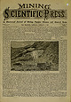
| moved it will require more larger quantities are mine by loading every third ascending help. This upper...these Huson patent tramways are in use in various mining districts, for transport- ing ore, supplies,...also, some of them carrying the men to and from the mine or mill. In mountainous districts they are invaluable...there be in saying portation of ores from ver mine to mill or point but gold in refineries, of shipment... mints, may times, HUSON TRAMWAY AT PAY-ROOK MINE. SILVER PLUMB, COLORADO. and storm as mid-day of |
 | | Report (issue) |
| or any other cultural features (city, village, county, township, crossroad, and railroad siding) are...this column are as follows: County (4th column)—This is the name of the county in which the listed entity...place, feature, or area lies in more than one county, the county listed is the one in which the center of...in the case of a stream, valley, or arroyo, the county listed is the one in which the feature's mouth...AL if Florence • Casa Grande GRAHAM Capital if County Seat COCHISE • Other Principal Cities Q____26____50 |
 | | Report (volume) |
| V E Y B C L L £ ~l . I \: I -1 ~ ~I Nine-county study of landslide acti·uity in relation to ancient...on Madera Avenue, city of San Carlos, San Mateo County, February 1969 _____ _________________________...Interstate Highway 80 near Pinole, Contra Costa County, May 1969 ______________ 6. Landslide damage to...San Jose Highlands, city of San Jose, Santa Clara County, December 1972________________________________________________...houses, Morningside Drive, Millbrae, San Mateo County _______________________________ ----8. Rainfall |
 | | Report (issue) |
| agencies and with county and local governments. Although the study focuses on the nine-county, 7 ,400-square-mile..._ _ _ _ _ _ _ _ _ _ _ _ _ _ _ _ _ _ 66 City and county general plans _ _ _ _ _ _ _ _ _ _ 67 Portola Valley...general plan _ _ _ _ _ _ _ _ _ _ _ _ _ _ _ 69 Sonoma County general plan ________ .:_ _ _ 71 Land-capability...agencies _ _ _ _ _ _ _ _ _ _ _ _ _ _ _ _ _ _ City and county agencies _ _ _ _ _ _ _ _ _ _ _ _ _ Application...landslide damage: Road north of Cloverdale in Sonoma County _ _ _ _ _ _ _ _ _ _ _ _ _ _ _ _ _ _ _ _ _ _ _ _ |


