 | | Journal (article/letter/editorial) | | Veins in Southeastern Missouri G. R. Lowell 1 and C. Gasparrini 2 1 Southeast Missouri State University,...Girardeau, MO 63701, USA 2 Minmet Scientific Ltd., Toronto, Ont., M4P 2H2, Canada Arsenopyrite occurs in greisen-sulfide...granite and rhyolite in the Silver Mine district of southeastern Missouri, Greisenization and sulfide...criteria imply that equilibrium existed between arsenopyrite and pyrite and that this pair crystallized in...microprobe spot analyses of 15 arsenopyrite crystals from the Einstein and Gabriel veins failed to disclose |  | | Journal (article/letter/editorial) | | SHERWOOD 106A East 25th, P. 0. Box 436 Oak Grove, Missouri 64075-0436 Downloaded by [Brown University Library]...Louis, Missouri 63129-2704 Figure 1. Counties in Missouri. N o comprehensive list of Missouri mineral...found in Missouri; two of these, fletcherite and starkeyite, were first described from Missouri mines....location a~ included at the end of each entry. Adair County Chariton River (40-04-05N 92-4 I -23W). septarian...septarian concretions about 2 miles north of the Macon county line. CALCITE crystals enclosing bundles of acicular |  | | Journal (article/letter/editorial) | | 1929 No. 6 AND ASSOCIATED MINERALIZATION SILVER MINE, MISSOURI. AT JOSEPH T. SINGEWALD, JR. AND CHARLES..................... 57o The Ozark The Later Mine Greisen ........................................ The Apex Mine ................................................ 582 The Einstein Silver Mini• .......59 ø INTRODUCTION. NINE miles west of Fredericktown, Missouri, on the west side of the St. Francis River...River, is a locality known as Silver Mine. It receivesits name from the fact that a half centuryago sulphide |  | | Report (issue) | | Region Rosiclare, Illinois to Ironton and Viburnum, Missouri June 30-July 8, t 989 Field Trip Guidebook Tt47...Peabody Drive Champaign, IL 61820 Eva B. Kisvarsanyi Missouri Dept. of Natural Resources Div. of Geology and...Dept. of Geology and Geophysics University of Missouri - Rolla Rolla, MO 65401 Associate Leaders: James...Dept. of Geology and Geophysics University of Missouri - Rolla Rolla, MO 65401 IGC FIELD TRIP T147:...Richard D. Hagni 4 COVER The Arch, St. Louis, Missouri. lIllinois State Geological Survey, Urbana, Illinois |  | | Report (issue) | | MINERAL-RESOURCE POTENTIAL OF THE ROLLA I°x2° QUADRANGLE, MISSOURI, AS APPRAISED IN SEPTEMBER 1980 Walden P. Pratt...Pratt, Editor Prepared in cooperation with the Missouri Department of Natural Resources, Division of Geology...selected areas in the Rolla 1°x2° quadrangle, Missouri.................................. Estimated amounts...selected areas of the Rolla I°x2° quadrangle, Missouri.................................................of rocks and minerals from Pilot Knob Mine, Iron County, Missouri............................ Spectrographic |  | | Book (volume) | | Dahlonega Co. and Rabum Co., and the McDuffie County Belt extending through portions of McDuffie, Warren...Sphalerite. BALDWIN COUNTY MILLEDGEVILLE, at state farmjasper. BANKS COUNTY COMMERCE, along Hwy. 59...along adjoining Co. linerock crystal. BARROW COUNTY WINDER, along rd. to Jefferson and 1½ mi. inside...Guide for Rock Hounds in the United States BARTOW COUNTY AREA, Saltpeter Cave, as floatjasper. CARTERSVILLE:...agate, (banded, various colors), jasper. BIBB COUNTY MACON: at Holton Quarry, 7½ mi. NWagate; N |  | | Book (volume) | | Most specimen collecting is done in the Lead-Zinc mining dists. of northwestern Illinois, the glacial drift...600 to 800 feet thick in the north. ALEXANDER COUNTY FAYVILLE, area stream gravels⎯agate, jasper, rare...⎯agate, jasper; d RR siding of Clay⎯agate. CALHOUN COUNTY AREA, shores of the Mississippi R., in the Warsaw...crystals). CRAWFORD COUNTY PALESTINE, area deposits⎯Siderite. EDWARDS COUNTY AREA, T. 1 S, R. 10 E...deposits⎯Siderite. FULTON COUNTY FARMINGTON, W 6 mi. on Rte. 116 to the Rapatee No. 5 strip mine⎯pyritized gastropods |  | | Book (volume) | | Most specimen collecting is done in the Lead-Zinc mining dists. of northwestern Illinois, the glacial drift...600 to 800 feet thick in the north. ALEXANDER COUNTY FAYVILLE, area stream gravels⎯agate, jasper, rare...⎯agate, jasper; d RR siding of Clay⎯agate. CALHOUN COUNTY AREA, shores of the Mississippi R., in the Warsaw...crystals). CRAWFORD COUNTY PALESTINE, area deposits⎯Siderite. EDWARDS COUNTY AREA, T. 1 S, R. 10 E...deposits⎯Siderite. FULTON COUNTY FARMINGTON, W 6 mi. on Rte. 116 to the Rapatee No. 5 strip mine⎯pyritized gastropods |  | | Report (volume) | | it helpful to refer to Survey Bulletin 507, "The mining districts of the western United States," and to...abundant, it may have been completely exhausted by mining or quarrying. Deposits of minerals of wide distribution...because they occur in sufficient quantity to warrant mining for their usual products but because they furnish... Mississippi.......Prof. E. N. Lowe, Jackson. Missouri..........Dr. H. A. Buehler, Rolla. Nebraska.....Morgantown. Wisconsin.........Prof. W. 0. Hotchkiss, Madison. Wyoming.........Mr. C. E. Jamison, Cheyenne. |  | | Report (volume) | | ....................................... 102 District of Columbia ................................................................................. Missouri.................................................to refer to Geological Survey Bulletin 507, "The mining districts of the western United States," and to...abundant it may have been completely exhausted by mining or quarrying. Deposits of minerals that are widely...because they occur in sufficient quantity to warrant mining for their usual products, but because they furnish |  | | Book | | stumble over a valuable nugget and stake your own mining claim? Indeed it to is, and author book Jay...prospecting, he points out, is in abandoned mining districts, where valuable mineral ores are present...commercial ores and secondary minerals by state, county, township, and geologic range. For easy identification...RANSOM 1875-1948 An to the Eastern '‘Schoolmarm” Mining Camps of the Old West I I a s I \ h K... CONTENTS Preface ix PART I 1 Introduction to Mining and Mineralogy 2 Preparation for Mineral Collecting |  | | Journal (article/letter/editorial) | | Gorceixitein topaz greisenassemblages, Silverminearea, Missouri Mnnr TnyloR, RosEnr W. Sirlrru, nNo Bnuce A...Minerals Corporation P. O. Box 500, Viburnum, Missouri 65566 Abstract . H2O]occursin the final stageof...titebariteis the latestbrecciacement. The Ozark mine gorceixite is chemicallyunique in severalrespects...sulfidemineralizationin the Silverminearea, MadisonCounty, Missouri, were describedby Singewald and Milton (1929)...and a later sulfide stagecomprisedof pyrite, arsenopyrite, chlorite, fluorite, sphalerite,chalcopyrite |  | | Book | | 1811-1812, at New Madrid, in the boot heel of Missouri. Church bells were set tolling as far east as.... . . . . . . . . 159 Appendix 1: Counties and County Seats of Illinois . . . . . . . . . . . . . . ...Cave-In-Rock, Hardin County .............................. xvi Drilling for crude oil, Clay County. . . . . . .... . . . . . . . . . . xx A surface coal mine, Jackson County . . . . . . . . . . . . . . . . . . . ....Shelter, Randolph County . . . . . . . 8 Limestone exposed in a quarry face, Jersey County . . . . . . . |  | | Journal (article/letter/editorial) | | (Rond6nia and Amazonas in Brazil, southeastern Missouri, southern Finland, the Ukraine, India); skarn-type...apatite-bearing Fe and Fe-Cu deposits of southeastern Missouri are associated with volcanics of the St. Francois...Vorkommen (Rond6nia und Amazonas in Brasilien, SE Missouri, S Finnland, 150 I. Haapala Ukraine, Indien);...Apatit-fiihrenden Fe- und Fe-Cu-Lagerst~itten yon SE Missouri sind mit Vulkaniten der Ringkomplexe in den St...deposits known from Amazonas and Rond6nia in Brazil, Missouri (U.S.A.), Russian Karelia, and India. Particularly |  | | Journal (issue) | | and Pyrite. 2 V2 x 2 V2 x 2 .. Graphite, Alibar Mine, Siberia. Xlline. fibrous . 3 x 2 ½ •. ..•.• . •...mass. 2 x 2 ¼ x 1 . ...••.•.•.. . ... E111boliN, Silver City, N. M. Xld. masses on Quartz, very good. 3...By Sa1n11ei C. Brotun ....499 MlNERALS OF THE SILVER MINE, MO., AREA. By Albert L. Kid1uell ........ 500...the same stone in creasing depth ; there is one mine over hctic the store, but this time in a case with...opportunity to do anything ried on by underground mining, and I : sol ro- about actual mineral collecting | 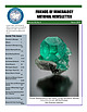 | | Journal (issue) | | track, to collect specimens underground at the Kelly mine, famous for exceptional blue-green botryoidal smithsonite...nearby Graphic mine, noted for azurite and malachite crystals, and visit the Blanchard mine to collect fine...included that of Ms. Blanchard at the Blanchard mine, who greeted someone she didn’t know with a shotgun... including periodic visits to Elk Creek, Meade County, to collect superb transparent golden barite found...actinolite, galena, molybdenite, chalcopyrite, arsenopyrite, limonite, feldspar, ilmenite, siderite, and |  | | Report (issue) | | information iuly 18 circular 1967 STATE OF MISSOURI DIVISION OF WC HAYES DEPARTMENT GEOLOGICAL... AND AND WATER DIRECTOR RESOURCES ROLLA MISSOURI Digitized by the Internet Archive in 2023 with...fgeO OOOj err , BIBLIOGRAPHY OF THE GEOLOGY OF MISSOURI 1966 by Jerry D. Vineyard / INFORMATION CIRCULAR...CIRCULAR NO. 18 July, 1967 STATE OF MISSOURI Department of Business and Administration Division of GEOLOGICAL...Director and State Geologist Rolla, Missouri STATE OF MISSOURI Warren E. Hearnes, Governor DEPARTMENT |  | | Report (issue) | | Dakota is the result of many years of discharge of mine wastes containing high concentrations of arsenic...headwaters of the Arkansas River receive water from mine drains and abandoned tailings that contains high...-----------------------------Map showing location of mine seeps and stream sampling sites -Graph showing ranges...about 2 kilometers downstream from an abandoned mine ---------------- C-14 C-19. C-14. C-15. C-16. C-17...determined for the samples --Chemical composition of mine seepage and streamwater, July 14, 1986 -------- |  | | Report (issue) | | Berger.............................................. Silver/base metal epithermal deposits, by Paul Barton...Trend subregion of the Southeast Missouri base metal and barite district, by A. V. Heyl...................structures containing Pags 3 Examples^ Skelletaa District, Sweden Hljura-Kotalenti Belt, Finland Thompson...the Langmuir deposit in Canada and the Kambalda district in Australia. Favorable targets for domestic deposits... Examples are the Thompson district in Canada and the Skellefte district in Sweden. Favorable target |  | | Book (volume) | | specific locations in Idaho, lowa, Kansas, Minnesota, Missouri, Montana, Nebraska, North Dakota, — ; Oregon...NORTHWESTERN QUANDRANT Idaho, Iowa, Kansas, Minnesota, Missouri, Montana, Nebraska, North Dakota, Oregon, South...Northwestern Quadrant Idaho, Iowa, Kansas, Minnesota, Missouri, Montana, Nebraska, North Dakota, Oregon, South...Location Numbers Idaho lowa Kansas Minnesota Missouri Montana Nebraska North Dakota Oregon South Dakota...volumes, through very precise directions and accurate county maps, to get you to the best and most accessible |  | | Journal (article/letter/editorial) | | States) and Keno Hill (Yukon Territory, Canada) mining districts demonstrate consistency between predicted...that much of the Ag mined from the Coeur d’Alene district was originally present in galena. They also confirm...polymetallic ore deposits and a major source of Ag to the mining industry. Our interest in fahlore derives from...from the Coeur d’Alene and Keno Hill districts, mining districts that have diverse fahlore compositions...constraints.4 Coeur d’Alene ores The Coeur d’Alene mining district in northern Idaho is one of the most extensively |  | | Journal (issue) | | of float copper was found in southern Houghton County and the larger mass was recovered a few miles west...Molybdenite Climax Mine, Lake County, Colorado Bob Werner werner@lcturbonet.com The Climax Mine, located in...in Lake County, Colorado (Fig. I), is perhaps the world's largest deposit of molybdenum (Mo) metal. The..."molybedamnite" or "molybedumdumite". The Climax Mine has operated on and off for over I 00 years and...expectation would be in vain. Specimens from the Climax Mine typically put real meaning to the term "aesthetically |  | | Report (issue) | | GOLD AND SILVER. THE AURIFEROUS GRAVELS OF THE TRINITY RIVER BASIN, CALIFORNIA. By J. S. DILLER. INTRODUCTION...ever since. Besides the La Grange mine, the largest hydraulic mine now in active operation, it contains...mines, particularly in the northern portion of the county. Large bodies of gravel of lower grade yet remain... Murphy, of the Union Hill mine; Mr. Pierre Bouery, of the La Grange mine; Mr. W. D. Ayers, of Poker...Globe mine; but more particularly to Mr. H. L. Lowden, formerly county surveyor of Trinity County, who |  | | Report (volume) | | MISSOURI GEOLOGICAL SURVEY VOLUME VI. LEAD AND ZINC DEPOSITS ( SECTION l) By ARTHUR W INSL OW ASSISTED...EXCELLENCY, DR. J. HON. WM. ,J. STONE, GOVERNOR OF MISSOURI, JEFFERSON CITY, ex officio President of the Board... CARTER, SECRETARY , LETTER OF TRANSMITTAL. MISSOURI GEOLOGIC.AL SURVEY,} JEFFERSON CITY, JULY 1,...of the Report on the Lead and Zinc Deposits of Missouri, by Mr. Arthur Winslow, assisted by Mr. James...with the idea of gathering a complete series of mine descriptions to form part of the report. Not until | 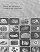 | Van Alstine, R. E., Worl, R.G., Heyl, A.V., Trace, R.D., Parker, R.L., Griffitts, W.R., Sainsbury, C.L., Cathcart, J.B. (1976) Geology and resources of fluorine in the United States. Professional Paper 933. US Geological Survey doi:10.3133/pp933 | Report (issue) | | 1. 2. 3. 4. 5. A sbestos ore Lead ore, Balmat mine, N . Y. Chromite-chromium ore, Washington Zinc ore...Survey in accordance with the provisions of the Mining and Minerals Policy Act of 1970 (Public Law 91-631...discovered or not currently profitable to mine. The mining of mineral deposits, once they are discovered.................. . Illinois-Kentucky fluorspar district, by R. D. Trace ................................... Missouri-Arkansas-central Texas ...................................... . Southeast Missouri .... |
|
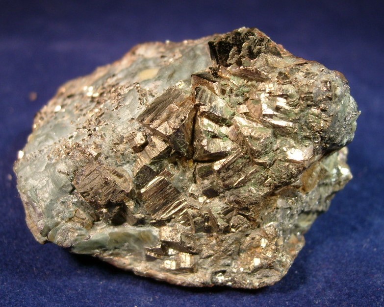
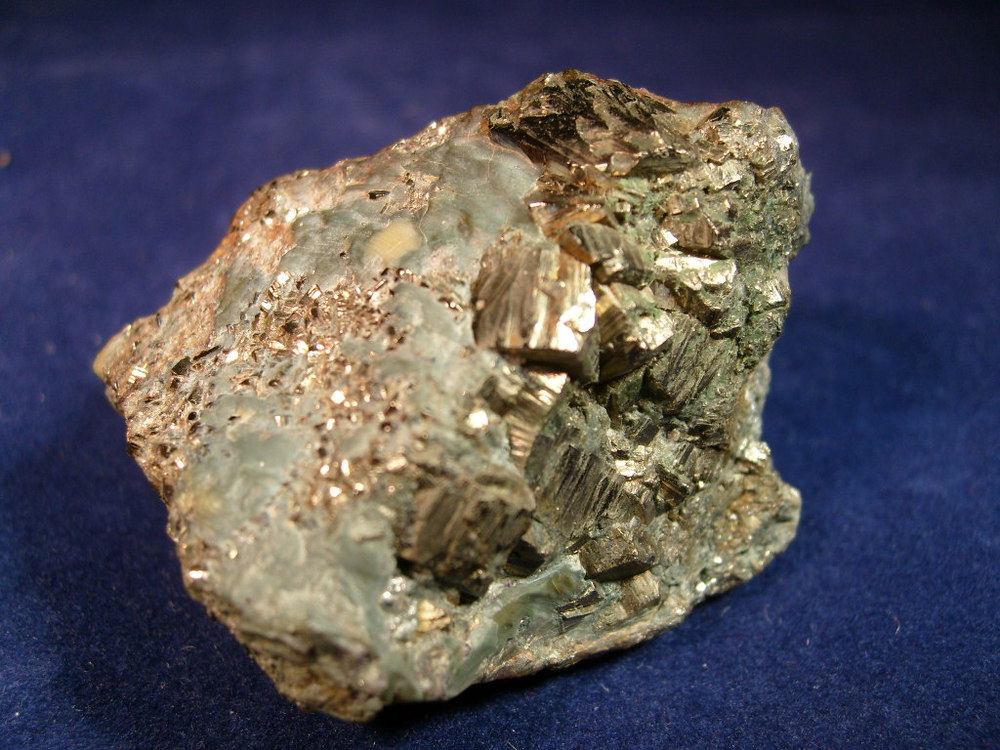


Einstein Mine, Silver Mine, Fredericktown Mining District, Madison County, Missouri, USA