| Locality type: | Mine Dump |
| Classification |
|---|
|
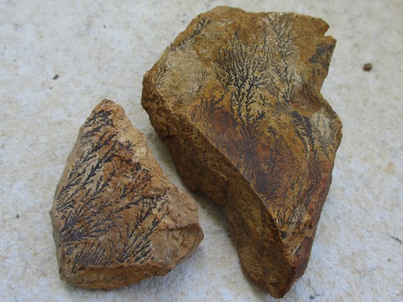
| Type: | Dolostone |
| Confirmation |
|---|
|
| Validity: | Confirmed |
| Confirmation Methods: | Visually Identified |
| Associated Minerals Based on Photo Data: |
|---|
|
| Manganese Dendrites | 1 photo of Dolostone associated with Manganese Dendrites at this locality. |
| Data |
|---|
|
| Mineral Data: | Click here to view Dolostone data |
| Locality Data: | Click here to view Hałda popłuczkowa, Friedrich Mine, Tarnowskie Góry, Tarnowskie Góry County, Silesian Voivodeship, Poland |
| Data Identifiers |
|---|
|
| Mindat Occurrence Record ID: | 1312552 |
| Long-form Identifier: | 1:3:1312552:1 |
| GUID (UUID V4): | 315e6590-b637-4049-86c0-38da7afa65ae |
| Nearest other occurrences of Dolostone |
|---|
|
|
| 0.6km (0.4 miles) | ⓘ"Bobrowniki" Dolomite Mine, Tarnowskie Góry, Tarnowskie Góry County, Silesian Voivodeship, Poland |
| 1.2km (0.8 miles) | ⓘ"Blachówka" dolomite quarry, Sucha Góra, Bytom, Silesian Voivodeship, Poland |
| 11.2km (7.0 miles) | ⓘOrzeł Biały dumps, Orzeł Biały mine, Brzeziny Śląskie, Piekary Śląskie, Silesian Voivodeship, Poland |
| 13.6km (8.5 miles) | ⓘSzczęście Flory Mine, Bibiela, Miasteczko Śląskie, Tarnowskie Góry County, Silesian Voivodeship, Poland |
| 36.6km (22.8 miles) | ⓘJemielnica, Gmina Jemielnica, Strzelce County, Opole Voivodeship, Poland |
| 38.5km (23.9 miles) | ⓘOld limestone quarry, Strzelce Opolskie, Gmina Strzelce Opolskie, Strzelce County, Opole Voivodeship, Poland |
| 40.6km (25.2 miles) | ⓘCementownia (Limestone quarry), Strzelce Opolskie, Gmina Strzelce Opolskie, Strzelce County, Opole Voivodeship, Poland |
| 53.5km (33.3 miles) | ⓘDolomite and limestone quarry, Otmice, Gmina Izbicko, Strzelce County, Opole Voivodeship, Poland |
| 61.4km (38.2 miles) | ⓘMiedziana gravel pit, Kosorowice, Gmina Tarnów Opolski, Opole County, Opole Voivodeship, Poland |
| References |
|---|
|
|


Hałda popłuczkowa, Friedrich Mine, Tarnowskie Góry, Tarnowskie Góry County, Silesian Voivodeship, Poland