 | | Journal (article/letter/editorial) | | a geological reconnoissance of the states of Wisconsin, Iowa, and Minnesota. Messrs. D. D. Owen, J. G...mention the occurrence of sheet and dyke gabbros in Wisconsin, and of dyke gabbros in the Animikie of Minnesota...Washington, 1851. 2Report of a Geological Survey of Wisconsin, Iowa, and Minnesota. By D. D. Owen. Philadelphia...establishment of the surveys of Minnesota, Michigan, and Wisconsin, however, an attempt was made to classify with...either. Among the geologists on the Michigan and Wisconsin surveys, Messrs. Julien, Wright, Wichman, Pumpelly |  | | Journal (article/letter/editorial) | | Sciences University of Wisconsin-River Falls 410 South Third Street River Falls, Wisconsin 54022 his is Wisconsin’s... breweries, bratwurst, and Packers football, Wisconsin also has a diverse geology and a history rich...forgotten, abandoned, and overgrown. In this respect, Wisconsin represents a frontier state for the mineral collector...Racine (Scovil 1994), the pegmatites of Florence County (Koehier 1989) and the Wausau area (Falster 1987)...summarizes and highlights what has been found in Wisconsin in the past 150 years and points the way to new |  | | Report (volume) | | Meridian of 76° 30', from Tompkins County, Hew York, to Bradford,County, Pennsylvania, by Henry S. Williams...iron-bearing series of the Penokee region of Wisconsin....... In the slates of the Saint Louis River...qnartzite formation of the Baraboo region of Wisconsin...... In the qnartzite formation of Southern Minnesota...39 40 41 41 In the Saint Peter's sandstone of Wisconsin........................ 41 In the Eureka quartzite...Peter's sandstone, Arlington Prairie, Columbia County, Wisconsin. No. 95 of the list, p. 42. The enlargements |  | | Journal (article/letter/editorial) | | Germany, to rocks composed essentially of a foliated augite and a "compact feldspar." Haüy describes the Euphotides...because of the supposition that the highly foliated augite in them really belonged to this and others showed...containing a triclinic feldspar and pyroxene (either augite, hypersthene or diallage) as true gabbros. He places...possession of labradorite or saussurite and platy augite, and divided them into two varieties-the gabbros...even at this early day, before it was known that augite could have imposed upon it a parting as the result |  | | Report (issue) | | United States Geological Survey. University op Wisconsin, Department of Geology and Mineralogy, Madison...Numakagon Lake of Wisconsin, including the Porcupine Mountains Section V. NoRTH^VESTERN Wisconsin and the adjoining...Beaver Bay, Minn. 24 35 1. N. W. i, Sec. 3, augite. W. Anorthite; non-diallagic — Fig. The same... Sec. 24, T. 50, K. 14 W. Anorthite; diallagic augite; titaniferous mag- Fig. 4. Fig. 2. netite...olivine-gabbro from Bladder Lake, Ashland County, Labradorito; augite; diallage; olivine, mostly fresh |  | | Journal (issue) | | Under the microscope these are seen to be aegerine augite intergrown with hornblende, and accom panied by...“wild and wooly” West as is in existence : P—-—-, Wisconsin, March, 5th, 18—, George, B. F—_, Wesr, medk ford...to I mite get Stuck on, Security, Sav ings bank ashland national bank Senitor Pane cleveland ohio are re...Express adres is Mellen ashland Co Wisconsin, My post ofice Adres, is Penokee, Wisconsin Send the bill to me...50, $3,50 Send By Express, to Mellen Ashland County, Wisconsin, My Post Oflice Adress, is Penokee Wis |  | | Report (volume) | | From the Silver King mine, Calico, San Bernardino County, Cal. Specific gravity, 6:28. Analysis by W. H...From .Teocalli Mountain, Brush Creek, Gunnison County, Colo. Specific gravity, 7.400 at 14.5°, corrected...vol. 3, pt. 1, p. 46. From the Rose mine, Grant County, N". Mex. Specific gravity, 6.644 at 20°. Probably...impurities. From the Missouri mine, Halls Valley, Park County, Colo. Analyses, by Hillebrand, of three different...From the Brobdignag mine, Red Mountain, San Juan County, Colo. Specific gravity, 5.21 at 18°. Analyzed |  | | Report (issue) | | Glacial map of northeastern Minnesota, northern Wisconsin, and northern peninsula of Michigan_ _ _ _ _ _...glacial lakes of northeastern Minnesota, northern Wisconsin, and northern peninsula of Michigan ________________...Outcr'op of Mowry shale on Thornton dome, Weston County, Wyo.; B, Hand specimen of Mowry shale collected...from Crook County, Wyo.; B, Thin section of Mowry shale from Thornton dome, Weston County, Wyo_ __ _...Corinth, Howard County, Ark.; B, Basal gravel of \Yoodbine formation, near Horatio, Sevier County, Ark_ _ _ |  | | Report (volume) | | ...................... 1. Rocks from Aroostook County..... ^..................'........... 2. Miscellaneous...1. Elliott County dike............................................... 2. Crittenden County dike............................................. 3. Colfax County................ I................................142 3. Plumas County............................................... 144 4. Butte County................................................. 146 5. Sierra County............................................... |  | | Report (volume) | | ...................... 1. Eocks from Aroostook County I............................. 19 19 2. Litchfieldite...56 1. Elliott County dike........................................ 56 2. Crittenden County dike............................................... 3. Colfax County......."............................................... 3. Plumas County .............................. .............. 4. Butte County............................ 177 178 179 184. 187 190 5. Sierra County ............................................ 6 |  | | Report (volume) | | crystalline rocks Maine 1. Rocks from Aroostook 'County 2. Miscellaneous rocks5 v New Hampshire 5 Vermont...Carolina Georgia Kentucky 1.. Elliott County dike 2. Crittenden County dike Tennessee Missouri Arkansas Oklahoma...Grande Canyon 5 2. Mount Taylor region 5 3. Colfax County 4. Miscellaneous rocks 5 Arizona 1. Globe district...Plumas County 4. Butte County 5 5. Sierra County5 6. Nevada City and Grass Valley 5 7. Placer County 8. Eldorado...Eldorado County 5 9. Amador County 5 10. Calaveras County5 11. Tuolumne County 5 12. Mariposa County5 |  | | Report (volume) | | TheElliott County dike ...................................... 92 2. The Crittenden County dike.......... f .......................... 198 3. Plumas County................................,,.............................................. . 204 5. Sierra County..................................................208 7. Placer County.....;......................................... 211 8. Eldorado County...............9. 'Araador County ............................................. 214 10. Calaveras County ........... |  | | Report (issue) | | The Penokee iron-bearing series of Michigan and Wisconsin by Roland Duer Irving and Charles Richard director...The Penokee iron-beariug series of Michigan and Wisconsin by Roland Duer Irving and Charles Richard Van...director Penokee iron-bearing series of Michigan and Wisconsin by Roland Duer Irving and Charles Richard Van... The Penokee Iron-Bearing Series of Northern Wisconsin and Michigan, by Roland D. Irving and C. R. Van...meridian of 76° 30', from Tompkins County, N. Y., to Bradford County, Pa., by Henry S. Williams. 1884. |  | | Journal (article/letter/editorial) | | Survey, National Center-MS 954, Reston, VA 22092, USA (Received October 10, 1990; accepted after revision...Survey, National Center--MS 954, Reston, VA 22092, USA. tinent rift system (MRS) of North America is one...\ 2.8-2.6 Ga o_L.jA., o 2.8-2.6 ONIARIO WISCONSIN 3.6-1.85 1.85 'li'J i MICHIGAN ILLINOIS ...rift south of LakeSuperiorin Minnesota,Michigan,Wisconsin,Iowa, Nebraska, and Kansas is inferred from gravityand...EASTERNSHORE, AGE LAKE SUPERIOR (Ma) ~ _o rONE I WISCONSIN fflON ~ F-LU Z (.9 JACOBSVILLE SANDSTONE |  | | Journal (volume) | | Germany, to rocks composed essentially of a foliated augite and Haiiy describes the Euphotides as cona "compact...because of the supposition that the highly foliated augite in variety of pyroxene. them really belonged...containing a triclinic feldspar and pyroxene (either augite, hypersthene or diallage) He them among the dolerites...possession of labradorite or saussurite and platy augite, and divided them into two varieties the gabbros...at this early day, before it it was known that augite could have imposed upon a parting as the result |  | | Report (volume) | | crystalline rocks Maine 1. Rocks from Aroostook County 2. Litchtieldite and associated minerals New lIampshire...Carolina (ieorgia Kentucky 1. Elliott County (like 2. Crittenden County dike Tennessee Missouri Arkansas Texas...Grande Canyon 2. Mount Taylor region 3. Colfax County 4. Miscellaneous rocks Arizona 1. Globe district...Butte County 5. Sierra County 6. Nevada City anti (lras Valley 7. Placer County 8. Eldorado County 9. Amador...Amador County 10. Calaveras County 11. Tuolumne County 12. Mariposa County 13. The quicksilver region |  | | Report (volume) | | West Virginia... .Dr. I. C. White, Morgantown. Wisconsin.........Prof. W. 0. Hotchkiss, Madison. Wyoming...See Bauxite and Hallpysite. Asbestos. Tallapoosa County, with corundum deposits near Dudleyville; not found...commercial quantity or quality. Asphalt. Colbert County, small quantity has been shipped from near Leighton;...following localities: Bibb County, Pratts Ferry; Calhoun County, near Tampa; Clay County, T. 20, Pv. 7 E.; Jefferson...Jefferson County, at Elyton; Lee County, at Chewacla lime works; St. Clair County, at Gfeensport; Shelby |  | | Book (volume) | | beds, excavations, etc.Selenite roses. BRULE COUNTY AREA: in the Oacoma zone of the Pierre Fm. On Elm...gray Barite rosette up to 5 or 6 inches. CAMPBELL COUNTY MOUND CITY, W to the Missouri R., regional hillsides...gravels, etc.petrified wood, wood opal. CORSON COUNTY LITTLE EAGLE: area ridges, slopes, stream beds...Guide for Rock Hounds in the United States CUSTER COUNTY AREA: The November Mine, 1.2 mi. SE of the Needles...of rd. a few yds., outcropRose Quartz. DOUGLAS COUNTY CORSICA, S on US 281 to Armour, area rd. cuts, |  | | Report (volume) | | ............................................ Wisconsin.................................................See Bauxite and Halloysite. Asbestos. Tallapoosa County, with corundum deposits near Dudleyville; not found...commercial quantity or quality. Asphalt. Colbert County, small quantity has been shipped from near Leighton;...following localities : Bibb County, Pratts Ferry; Calhoun County, near Tampa; Clay County, T. 20 S., R. 7 E.;...; Jefferson County, at Ely ton; Lee County, at Chewacla lime works"; St. Clair County, at Greensport; |  | | Book (volume) | | ASHTABULA COUNTY CONNEAUT, area pits, quarries, rd. cuts, etc.⎯cone-in-cone Calcite. CLERMONT COUNTY MILFORD...CLINTON COUNTY WILMINGTON, area of Todd’s Ford, a mineral deposit⎯Hematite. COSHOCTON COUNTY AREA, townships...CUYAHOGA COUNTY CHAGRIN FALLS (on Geauga Co. line), area quarries⎯oilstone. DELAWARE COUNTY DELAWARE...nodules⎯Pyrite (crystals sharply cubic). FRANKLIN COUNTY COLUMBUS, area countywide exposures of blue clay...HIGHLAND COUNTY SINKING SPRING, area ore deposit (most important in Ohio) ⎯Hematite. HOCKING COUNTY AREA |  | | Book (volume) | | ASHTABULA COUNTY CONNEAUT, area pits, quarries, rd. cuts, etc.⎯cone-in-cone Calcite. CLERMONT COUNTY MILFORD...CLINTON COUNTY WILMINGTON, area of Todd’s Ford, a mineral deposit⎯Hematite. COSHOCTON COUNTY AREA, townships...CUYAHOGA COUNTY CHAGRIN FALLS (on Geauga Co. line), area quarries⎯oilstone. DELAWARE COUNTY DELAWARE...nodules⎯Pyrite (crystals sharply cubic). FRANKLIN COUNTY COLUMBUS, area countywide exposures of blue clay...HIGHLAND COUNTY SINKING SPRING, area ore deposit (most important in Ohio) ⎯Hematite. HOCKING COUNTY AREA |  | | Report (volume) | | geology and mining industry of Leadville, Lake County, Colorado, by S. F. Emmons, pp. 201-290, pis. xliv-xlv...The Penokee iron-bearing series of Michigan and Wisconsin, by Koland Duer Irving and Charles Eichard Van...and hydrography Continued. The mines of Ouster County, Colorado, by Samuel Franklin Emmons, pp. 405-472...The age of the Franklin white limestone of Sussex County, New Jersey, by John Eliot Wolff and Alfred Hulse...township 37 south, inclusive; together with the Ashland Forest Reserve and adjacent forest regions from |  | | Report (volume) | | with State and local historical societies, State, county, and township officers, and individuals in all...Historical Library, Helena, Montana, for data concerning county and town names in the State. Eugene Howell, by...counties. Nearly all the information concerning county names in this State was furnished by him. John...connection with the State names. Complete lists of county and town names were sent by him, and information...of county and town names. John M. Comstock, Chelsea, Vermont, list of town names in Orange County. Virginia |  | | Report (volume) | | with State and local historical societies, State, county, and township officers, and individuals in all...Wyoming, Illinois, superintendent of schools, Stark County, 1882-1898, for much valuable information concerning...several hundred cities and towns, and corrections of county names in the State of Illinois. J. P. Dunn, Indiana...Indianapolis, Indiana, for additions to and corrections of county names. M. W. Davis, State Historical Society, Iowa...fora revision of the complete list of Minnesota county names. Franklin L. Riley, Mississippi Historical |  | | Report (volume) | | Wisconsin____________________ 338 Chippewa River and Barron County ___________ 338 Central Minnesota ______________________...Richardson for Texas, Samuel Weidman for central Wisconsin, Alfred H. Brooks for Alaska, John A. Dresser...isolated areas of pre-Cambrian rocks appear in Wisconsin, Minnesota, Iowa, Dakota, Missouri, Indian Territory...Baraboo, Waterloo, Necedah, and Sioux areas of Wisconsin and Minnesota. Missouri. Oklahoma. Algonkian:...by granites and gneisses. Western Texas (El Paso County). Sediments and schists in Franklin and Diablo |
|

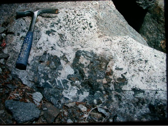


Quarry Road quarry, Ashland County, Wisconsin, USA