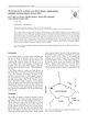
Log InRegister
Quick Links : The Mindat ManualThe Rock H. Currier Digital LibraryMindat Newsletter [Free Download]
Home PageAbout MindatThe Mindat ManualHistory of MindatCopyright StatusWho We AreContact UsAdvertise on Mindat
Donate to MindatCorporate SponsorshipSponsor a PageSponsored PagesMindat AdvertisersAdvertise on Mindat
Learning CenterWhat is a mineral?The most common minerals on earthInformation for EducatorsMindat ArticlesThe ElementsThe Rock H. Currier Digital LibraryGeologic Time
Minerals by PropertiesMinerals by ChemistryAdvanced Locality SearchRandom MineralRandom LocalitySearch by minIDLocalities Near MeSearch ArticlesSearch GlossaryMore Search Options
Search For:
Mineral Name:
Locality Name:
Keyword(s):
 
The Mindat ManualAdd a New PhotoRate PhotosLocality Edit ReportCoordinate Completion ReportAdd Glossary Item
Mining CompaniesStatisticsUsersMineral MuseumsClubs & OrganizationsMineral Shows & EventsThe Mindat DirectoryDevice SettingsThe Mineral Quiz
Photo SearchPhoto GalleriesSearch by ColorNew Photos TodayNew Photos YesterdayMembers' Photo GalleriesPast Photo of the Day GalleryPhotography

Gold (commodity) from
Krudum, Třídomí, Horní Slavkov, Sokolov District, Karlovy Vary Region, Czech Republic


Locality type:Mountain
Classification
Commodity:Gold (commodity)
Data
Commodity Data:Click here to view Gold (commodity) data
Locality Data:Click here to view Krudum, Třídomí, Horní Slavkov, Sokolov District, Karlovy Vary Region, Czech Republic
Data Identifiers
Mindat Occurrence Record ID:1596433
Long-form Identifier:1:3:1596433:1
GUID (UUID V4):4f634c4d-464c-4072-8210-0377bf6cd38e
Nearest other deposits of Gold (commodity)
72.9km (45.3 miles) Jakobi Schacht, Brandholz, Goldkronach, Bayreuth District, Upper Franconia, Bavaria, Germany
74.1km (46.0 miles) Schmutzler-Schacht, Brandholz, Goldkronach, Bayreuth District, Upper Franconia, Bavaria, Germany
74.1km (46.0 miles) Ludwig Wittmann-Schacht mine, Brandholz, Goldkronach, Bayreuth District, Upper Franconia, Bavaria, Germany
74.3km (46.2 miles) Tiefer Schmutzler-Stollen (Schmutzler adit), Brandholz, Goldkronach, Bayreuth District, Upper Franconia, Bavaria, Germany
74.4km (46.2 miles) Mittlerer Name Gottes mine (Mittlerer Name Gottes adit), Brandholz, Goldkronach, Bayreuth District, Upper Franconia, Bavaria, Germany
74.9km (46.6 miles) Silberne Rose Mine, Goldkronach, Bayreuth District, Upper Franconia, Bavaria, Germany
Reference Search (possible matching items)
Journal (article/letter/editorial)
of the Czech Geological Society 51/1–2(2006) 3 The Krásno Sn-W ore district near Horní Slavkov: mining...SEJKORA2 1 2 Regional Museum Sokolov, Zámecká 1, Sokolov, CZ-356 00, Czech Republic Department of Mineralogy...1, CZ-115 79, Czech Republic The tin-tungsten Krásno ore district near Horní Slavkov (Slavkovský les...most important areas of ancient mining in the Czech Republic. The exceptionally rich and variable mineral...setting of the ore district, individual ore deposits and mining history. Horní Slavkov and Krásno were known
Book
Jarchovský Govind S. Rajpoot Czech Geological Survey Prague 2010 CZECH GEOLOGICAL SURVEY ATLAS of plutonic...Waste Repository Authority of the Czech Republic (RAWRA) and by the Czech Geological Survey. Acknowledgements...author Josef Klomínský, Czech Geological Survey, Klárov 131/3, Prague 1, Czech Republic. Fax (+420) 257 531...b a Czech Geological Survey, Klárov 131/3, Praha 1, b Náchodská 2030, Praha 9, Czech Republic Contents...Geological map of Czechoslovakia 1 : 500,000. – Czech Geol. Survey, Prague. 1. CENTRAL BOHEMIAN COMPOSITE
Book
Mercury, Niobium and Tantalum, and Zirconium 150. V GOLD 168 1. Summary 168; 2. Production 168; 3. Exports...raw materials, and labor per unit of value created vary considerably from one economic activity, such as...mercury, niobium and tantalum, and zirconium; 3. Gold; 4. Coal and lignite; 5. Petroleum, natural gas...locates each deposit by official 1946 Economic Region; also, by coordinates, in the index of place names...production trends ( 1926-1950), both nationally and by region; foreign trade; mineral consumption and utilization
 
Mineral and/or Locality  
Mindat Discussions Facebook Logo Instagram Logo Discord Logo
Mindat.org is an outreach project of the Hudson Institute of Mineralogy, a 501(c)(3) not-for-profit organization.
Copyright © mindat.org and the Hudson Institute of Mineralogy 1993-2024, except where stated. Most political location boundaries are © OpenStreetMap contributors. Mindat.org relies on the contributions of thousands of members and supporters. Founded in 2000 by Jolyon Ralph.
Privacy Policy - Terms & Conditions - Contact Us / DMCA issues - Report a bug/vulnerability Current server date and time: April 30, 2024 02:57:09
Go to top of page