 | | Report (issue) |
| KINERAL Rl!SOURC!li OF THE 'miNITY RIVER 'miBUTARY AREA TEXAS AND OKLAHOMA Compiled by 'lHE UNITED...~;eiaaeboi'D • • • • I:Iiner&l reaourcea of: the Trinity RiYer tributary area Fuels and related prouucta...C . 1-'ou.<'ltain, end D. N. I:iDney • • • • • Gypsum and auhycr'i ·i:e ".Jy l>. u. Kinney • • • • •...98 Dolomite .:nd ~~~nesian Limestone • • • J,Ol Gypsum • • • • • • • • • • • • • • • • 106 Helium • •...for the improvement of navigation on the Trinity River in Texas have been under consideration for many |
 | | Report (issue) |
| print of high-calcium Edwards Limestone, Real County, Texas, showing cross sections of pelecypod and gastropod...organized research bureaus of The University of Texas. Established in 1909, it has for 53 years cartied...research and public service in earth science and Texas mineral resources as follows: (1) basic geological...Bureau publishes major reports in The University of Texas publication series; it also has its own series of...published: ( 1 ) two major reports in The University of Texas Publication series (Nos. 6120 and 6210) ; ( 2 ) |
 | | Report (issue) |
| University of Texas Bulletin No. 1869: December 10, 1918 Okla. Geol Survey THE GEOLOGY OF EAST TEXAS By E...SECOND-CLASS MATTER AT THE POSTOFFICE AT AUSTIN. TEXAS. UNDER THE ACT OF AUGUST 24, 1912 The benefits...the preservation of a free govern- ment. Sam Houston Cultivated mind is the guardian genius of democracy...—Pre-Cretaceous Cretaceous Lower Cretaceous^Comanchean Trinity Fredericksburg . Washita Comanchean Sections...Tertiary Introduction Tertiary Formations of East Texas Tertiary Sections Eocene Midway General Character |
 | | Journal (article/letter/editorial) |
| PLS. 25-27 DECEMBER 4, 19 15 PROBLEM OF TH E TEXAS TERTIARY SANDS 1 BY E. T. DUMBLE (Read before the.......... 457 Descriptions of formations of east Texas...................................................which stretch entirely across the Coastal Plain of Texas, there is a narrow belt within which the outcrops...sands are present, unless it be on the Colorado River. On the Rio Grande the Fayette is overlain by the...Louisiana in 1869, visited some localities in east Texas, where hefoundthe extension of his Grand Gulf beds |
 | | Report (issue) |
| University of Texas Bulletin No. 1931: June 1, 1919 THE GEOLOGY OF TARRANT COUNTY By W. M. WINTON...Second-Class Matter at the Postoffice at Austin, Texas, Under the Act of August 24, 1912. GEOLOGY i ...to the preservation of a free government. Sam Houston Cultivated mind is the guardian genius of democracy...TOPOGRAPHY 9 Topographic Divisions of Tarrant County Black Prairie Ea'stern Cross Timbers 9 9 10...Geological * . Map Type Localities in Tarrant County FOSSILS AS HORIZON MARKERS Mode of Preservation |
 | | Journal (article/letter/editorial) |
| Texas mineral locality INDEX Whereas Texas is well known for its vastness, cattle industry, and oil...mineralogically. ARTHUR E . SMITH 9118 C o n c h o Houston, T e x a s 77036 IN S P I T E O F I T S T O P...P O G R A P H Y A N D G E O L O G Y , Texas, the second largest state, has produced relatively few mineral...famous localities. A s this article will show, Texas has had—or currently has—nu merous mineral occurrences...produce good specimens; yet when specimens from Texas are sought in collections and dealers' stocks, few |
 | | Report (issue) |
| THE. PALESTINE SALT DOME, ANDERSON COUNTY, TEXAS. By OLIVER B. HOPKINS. INTRODUCTION. The Palestine...The Palestine salt dome is in Anderson County, eastern Texas, 6 miles south of west of Palestine. It...Creek about 6 miles from its confluence with Trinity River. This dome is roughly in line with the Keechi...on the geology of the Gulf Tertiaries of Texas [etc.] : Texas Geol. Survey First Ann. Kept., pp. 33-34...33-34, 1890.. a Dumble, E. T., Anderson County: Texas Geol. Survey Second Ann. Rept, pp. 304-305, 315-317 |
 | | Report (volume) |
| GOLD AND SILVER: The auriferous gravels of the Trinity River basin, Gal., by J. S. Diller.... The economic...economic geology of Carson camp, Hinsdale County, Colo., by E. S. Larsen.....................................Metalliferous ore deposits near the Burro Mountains, Grant County, N. Mex., by Sidney Paige........................ZINC: Notes on lead and copper deposits in the Bear River Range, Idaho and Utah, by R. W. Richards..........stone: Variegated marble southeast of Calera, Shelby County, Ala., by Charles Butts....................... |
 | | Report (issue) |
| HYDROLOGIC SUMMARY OF SALT DOMES IN GULF COAST REGION OF TEXAS, LOUISIANA, MISSISSIPPI, AND ALABAMA By R. Ernest...water-------------------- ----------------------- 35 Northeast Texas salt-dome basin------------------------------- ...water---------------------------------------- 73 East Texas-south Louisiana salt-dome basin--------------------...------- Hydrology--- --- -- -------- South Texas salt-dome basin-----------------------------------...------------- ---------------- 101 Northeast Texas salt-dome basin-------------------------- 102 |
 | | Journal (article/letter/editorial) |
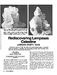
| cm across. Rediscovering Lampasas LAMPASAS COUNTY, TEXAS During the summer of 1989, the author and several...REGION SURROUNDING the city of Lampasas, Texas (and the county of the same name), has long been recognized...Geographically, Lampasas is located in that part of central Texas commonly known as the “Hill Country,” a sprawling...Antonio. Considered in this article are Lampasas County and portions of the nearby counties of Brown, Mills... and Williamson. 1 7 - I, Anhydrite and/or gypsum Pyrite and marcasite Suggested sequence of mineralization |
 | | Report (volume) |
| SURVEY CHARLES D. WALCOTT, DIRECTOR GAZETTEEK OF TEXAS BY HENRY G-A-NNETT WASHINGTON GOVERNMENT PRINTING.... 18 ILLUSTRATIONS. Page. PF,ATE I. Map of Texas ..................................................as a bulletin, the manner ipt of a gazetteer of Texas. Very respectfully, HENRY GANNETT, Geographer. Hon...Geological Survey. A GAZETTEER OF TEXAS. By HENRY GANNKTT. AREA. Texas, formerly a State of Mexico, Avas...from the west bank of Sabine River and Lake to the center of the river and lake. In 1850 the State sold |
 | | Report (volume) |
| CHARLES D. WALCOTT, DIRECTOR A. G-AZETTEEK OF TEXAS (SEOCGSTD ZEIDITIOZNT) BY HENRY GLANNETT WASHINGTON...bulletin, the revised manuscript of a gazetteer of Texas. This is a second edition, the first edition having-...Geological Survey. 1 A GAZETTEER OF TEXAS. HENRY GANNETT. AREA. Texas, formerly a State of Mexico, was...from the west bank of Sabine River and Lake to the center of the river and lake. - In 1850 the State...present dimensions. The present boundary line of Texas is as follows: Beginning in the Gulf of Mexico at |
 | | Report (volume) |
| CHARLKS Ii. W.VU'OTT, IMKKCTOK OIL FIELDS OF THK TEXAS-LOUISIANA GULF COASTAL PLAIN C. W. HAYES AND WILLIAM...--...--.-. Detailed sections between Brazos and Trinity rivers............... Detailed sections in vicinity............................. 124 125 125 Minor Texas districts ................................................... 125 Big Hill, Jefferson County _-_-_...-__.-_-__--..--.......--._-_.._ DaytonHill ........................... 127 Big Hill, Matagorda County -.------.-..-----....-....-....---..Jennings district |
 | | Report (Issue volume) |
| Absolute ate, dates Carbo11 /4 Continental shelf. Texas, sediments: t:mer), K. 0. 10996 Florida· Bullen...University Laboratory: Rusnak. G . A 04425 Texas. Atascosa County, water. Carrizo Sand: Pearson, F J_, Jr...J .. Jr. I 1499 Texas. Lampasas River terraces. shells: Cheatum. E. P. I 1348 Texas University laboratory...D . Jr. 06236 Chocta-.. County. map: Toulmin. L. D . 1)6256 Chocta-.. County. Quitman fault zone, reconnaissance...Tounelot, H A . 06226 Clar,e County. along State Highwa) 69 and County Highway 15, cross section Toulmin |
 | | Book |
| HARRIS COUNTY PUBLIC LIBRARY EOLOGY of TEXAS Darwin Spearing KW 3 4028 05687 8482 HARRIS COUNTY PUBLIC...only APR 0 9 1997 ?//f(ff ROADSIDE feOLOGY of Texas Darwin Spearing MOUNTAIN PRESS PUBLISHING COMPANY...ion Data Spearing, Darwin. Roadside geology of Texas / Darwin Spearing. p. cm. — (Roadside geology series...series.) Rev. ed. of: Roaside geology of Texas / Robert A. Sheldon. 1979 Includes bibliographical references...index. ISBN 0-87842-265-X 1. Geology Texas Guide-books. 2. Texas—Description and travel 1981 Guide-books |
 | | Report (issue) |
| Sediment Yields for Selected Streatns in Texas By C. T. F elborn tJlld R. Bryce Besant U.S. GEOLOGICAL...report 78-83 February 1978 Reproduced by the Texas Department of Water Resources as a part of the continuing...Creek near Electra, Texas (07312200)-----------------Wichita River at Wichita Falls, Texas (07312500)------------East...(07312500)------------East Fork Little Wichita River near Henrietta, Texas (07315200)-----------------------------...near Sadler, Texas (07316200)-----------------Elm Fork Trinity River near Sanger, Texas (08050500)--------Isle |
 | | Journal (article/letter/editorial) |
| Observations on the Geography of Texas Author(s): William Bollaert Source: Journal of the Royal Geographical...f=' _ VII.-ObSe7UatSOnS oel tAleGeogrsl}i31 of Texas. By NVILLIAM BOLLAERT, Esq., F.R.G.S. [Read JaIluary...the Union. Its coast boundarybep;insat the Sabine River,runsalong the Gulf of Mexico to the Rio Grande del...m()untainous, I'he firstappearanceof the coastof Texas is unfavourable;if approachedby sea a los sandy...constitutesanotileranent of accunlulation. The i31etsandbars of Texas are gradually encroachingupon the sea, and thus |
 | | Report (issue) |
| Ground-Water References for All 254 Counties in Texas, 1886–2001 Open-File Report 2005–1270 U.S. Department...Ground-Water References for All 254 Counties in Texas, 1886–2001 Compiled By E.T. Baker, Jr. Open-File...ground-water references for all 254 counties in Texas, 1886–2001: U.S. Geological Survey Open-File Report...Ground-Water References for All 254 Counties in Texas, 1886–2001 Compiled by E.T. Baker, Jr. U.S. Geological...ground-water references involving all 254 counties in Texas. The reference citations date from 1886 and extend |
 | | Book |
| conversion to alumina. The iron ore is barged up river to the Birmingham area for use in the steel plants...Interstate 30 are visible from a number of State and county roads. Ark. 183, which intersects Interstate 30...of Hot Springs, and 2 miles north of Magnet on a county road, is the largest barite mine in America (map...operated. but may be viewed from a eastward trending county road. The mine is one of several in what at one...a point 5 miles south of Magnolia on U.S. 79, a county road to the west passes just north of the bromine |
 | | Report (issue) |
| Louisiana and Mississippi and of the Yegua Formation of Texas GEOLOGICAL SURVEY PROFESSIONAL PAPER 569-B Geohydrologic...Louisiana and Mississippi and of the Yegua Formation of Texas By J. N. PAYNE GEOHYDROLOGY OF THE GEOLOGICAL ...associated formations in southwestern Louisiana and Texas. 2-7. Maps showing: 2. Structure contours on the...Yegua Formations in Louisiana, Mississippi, and Texas. 3. Sand-percentage distribution and thickness of...Yegua Formations in Loui&iana, Mississippi, and Texas. 4. The maximum sand-unit thickness in the Cockfield |
 | | Journal (article/letter/editorial) |
| COASTAL SALT DOMES. ByWiu.iAM KENNEDY, Fort Worth, Texas. (Tulsa Meeting, February. 1917. j The geology...extend from the Mississippi River westward across the states of Louisiana and Texas, and for many miles southward...as the Colorado River the country is mostly low lying and marshy. West of this river the country becomes...increasing as we go south and west until in Cameron County in Texas and Tamaulipas in Mexico, it may be said, the...such as the Trinity, Brazos, and Colorado, together with the Neches and Sabine in Texas; the Calcasieu |
 | | Journal (article/letter/editorial) |
| THE WEST POINT, TEXAS, SALT DOME FREESTONE COUNTY E. DEGOLYER 65 Broadway, New York City, New York INTRODUCTION...the extreme southeastern corner of Freestone County, Texas. This dome structureis one of the most symmetrical...published. Deussen' referred to a dome in Freestone County as one of the inner belt of coastal 2 domes, and...geologists of the IAlexanler Deussen, "The Humble, Texas, Oil Field," Southwestern Assn. Pet. Geol., Bull...Anderson County, Texas," U. S. Geol. Survey, Bull. 661g (1917). 4 E. T. Dumble, "Origin of the Texas Domes |
 | | Report (issue) |
| Fisher, Director*The University of Texas at Austin* Austin, Texas 787157508 Foreword The Bureau of...in 1909 as the successor to the Texas Geological Survey and the Texas Mineral Survey, is a research entity...entity of The University of Texas at Austin. It also functions as the State Geological Survey, a quasi-State...quasi-State agency, and the Bureau Director represents Texas in the Association of American State Geologists...informational. services relating to the resource Texas are provided by the B u r e ~ Bureau conducts basic |
 | | Journal (article/letter/editorial) |
| JOEL A. BARTSCH Houston Museum of Natural Science One Hermann Circle Drive Houston, Texas 77030-1799 Flashback...fine-quality, well-crystallized mineral specimens, Texas localities fall way short when compared to worldwide...misguided Texas patriots start hollerin’ at me, I am acutely aware that the pride of Texas is staked...in Terlingua, but few people will argue that a Texas mineral specimen will probably never be selected...that I was pleased to see a mineral specimen from Texas on the cover of this issue. The specimen is an 8-inch-tall |
 | | Report (issue) |
| BIBLIOGRAPHY OF THE EDWARDS AQUIFER, TEXAS, THROUGH 1993 Compiled by Julie A. Menard U.S. GEOLOGICAL...RESEARCH IN WATER RESOURCES, UNIVERSITY OF TEXAS AT AUSTIN Austin, Texas 1995 U.S. DEPARTMENT OF THE INTERIOR...1. Map showing location of the Edwards aquifer, Texas TABLE 1. List of bibliographic data bases searched...kilometer Bibliography of the Edwards Aquifer, Texas, Through 1993 Compiled'byr Julie A. Menard Abstract...literature for the three regions of the Edwards aquifer, Texas San Antonio area; Barton Springs segment, Austin |


