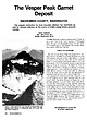
 | | Journal (article/letter/editorial) | | The Vesper Peak Garnet Deposit SNOHOMISH COUNTY, WASHINGTON This popular destination peal for mineral...grossular BART CANNON 1041 100th Street, NE Seattle, Washington 98125 V E S P E R P E A K IS A S N O W - C A...in the North Cascades of Washington State. The peak is in Snohomish County, 45 miles north east of Seattle...city. History and Ownership The area around Vesper Peak was prospected for pre cious metals in the 1890s...Pat Crane, a mining engineer and mineral collector who lived in the nearby town of Snohomish, located a |  | | Book | | Bart Cannon 1975 CORD ILLERAN Mercer Island, Washington Lilli liliiiLt' 111? KLi-KlLLLIlrVlIlI Copyright...Cordilleran 18 Holly Hill Drive Mercer Island, Washington 98040 COVER ILLUSTRATION: Amethyst scepter heads...milky quartz stems. Denny Mountain area of King County. Specimen from the collection of Cary A. Maykut...publications dealing with the various aspects of Washington State's diverse mineral wealth exist, but none..."Minerals of Washington" represents an attempt to begin such a cata logue. "Minerals of Washington" shall |  | | Journal (article/letter/editorial) | | New Mexico, 57; Washington, 318 185-256 May/June (No. 3) Bastnkite-(Ce), Washington, 454 257-360 July/Aug...Bastnkite, Washington, 457 361440 Sept./Oct. (No. 5) Bearss, G., The Weeks Pegmatite Mine, Wakefield...Wakefield, Carroll County, New Hamp441-512 Nov./Dec. (No. 6) shire, 129-135 Becker, R., Minerals of the Golden...Batholith, Okanogan County, Washington, 450-459 January/February: Azurite, Copper Queen mine, Bisbee, Arizona;...Chip Clark photo. lecting Localities in Western Washington MarchIApril: Labuntsovite, Mont SaintState, 330-334 |  | | Report (Issue volume) | | State of Washington ARTHUR B. LANGLIE, Governor Department of Conservation and Development W. A. GALBRAITH...GLOVER, Supervisor Bulletin No. 37 INVENTORY OF WASHINGTON MINERALS PART II METALLIC MINERALS By MARSHALL...Volume 2 - MAPS STATE PRINTING PLANT. OLYMPIA, WASHINGTON lll!UI For sale by Department of Conservation...volumes-text and maps) $4.50. INVENTORY OF WASHINGTON MINERALS PART II METALLIC MINERALS Volume 1...Bulletin 33, "Nonmetallic Mineral Resources of Washington," published in 1936. Since then the catalogue |  | | Book | | for naming stilbite, analcime, harmotome, and laumontite although he only popularized and more completely...formed the basis of the zeolite group, which has 48 species accepted by the IMA today (see Zeolite Time...faujasite, ferrierite, gmelinite, goosecreekite, laumontite, levyne, mazzite, merlinoite, montesommaite,...pressure collapses. At high pressure heulandite or laumontite is replaced by lawsonite, and analcime by albite...scattered sites. Rarely, erionite, mordenite, and laumontite are found. Merlinoite is found with plagioclase | | | Book | | for naming stilbite, analcime, harmotome, and laumontite although he only popularized and more completely...formed the basis of the zeolite group, which has 48 species accepted by the IMA today (see Zeolite Time...faujasite, ferrierite, gmelinite, goosecreekite, laumontite, levyne, mazzite, merlinoite, montesommaite,...pressure collapses. At high pressure heulandite or laumontite is replaced by lawsonite, and analcime by albite...scattered sites. Rarely, erionite, mordenite, and laumontite are found. Merlinoite is found with plagioclase |  | | Book | | long (Marty, 2004 ). AFRICA widely in Litchfield County, where good crystals were taken from quartz veins...region (Brunet, I 977b ). NEW YORK Amity, Orange County. At many isolated collected sites between the towns...Mount Malosa, Chilwa alkaline province, Zomba district. "Illite" is the name of a series of incompletely...Litchfield County. Ilmenite masses and crystals from somewhere near Washington, Litchfield County, were described...Lake Road occurrence, Faraday Township, Hastings County. In fall 1994, Dan and Shelley Lambert extracted |  | | Report (issue) | | GEOLOGY AND EARTH RESOURCES DIVISION OLYMPIA, WASHiNGTON 98504 METAL MINES OF WASHINGTONPRELIMINARY REPORT...DERKEY NANCY L. JOSEPH and RAYMOND LASMANIS WASHINGTON DIVISION OF GEOLOGY AND EARTH RESOURCES OPEN...Earth Resources standards and nomenclature. 1, WASHINGTON STATE DEPARTMENT OF Natural Resources Brian...DERKEY NANCY L. JOSEPH and RAYMOND LASMANIS WASHINGTON DIVISION OF GEOLOGY AND EARTH RESOURCES OPEN...standards and nomenclature. • CONTENTS Page Page County and site name Kelly Camp Kettle Key East Knob |  | | Report (issue) | | Australia, it is often necessary to christen a new mining field, and to assign names to its creeks, gullies...north-west of C.”; A, B, and C may all be in the same district, but it is sometimes difficult or impossible to...” “Leigh Creek,” “Avondale Mine”; all these are in the Leigh Creek District, and there may be but one...Zmc-lead Salphide Deposits of the Read-Rosebery District. Bull. Geol. Surv, Tas., 23, 1915. .Jensen (H...Mount Shamrock Mine. Ihid., No. 168, 1901. 34. On the Mount Biggenden Gold and Bismuth Mine and Paradise |  | | Report (issue) | | ....................4 Todd (St. Stephen Nickel) mine......................................................................10 Blakeney (Basswood Ridge) mine........................................................................11 The Ledge (Charlotte County Granite) quarry..................................................................21 Oliver Cameron mine...................................................Louisiana) mine.......................................................................24 Letete mine...... |  | | Report (volume) | | species UNITED STATES GOVERNMENT PRINTING OFFICE, WASHINGTON : 1961 'UNITED STATES DEPARTMENT OF THE INTERIOR...location and means of access to all the metallic mining districts in the State, as well as a large number...documented summary of the beginning of Colorado mining history. Part of his summary is given here in the...had been recently found in the Tenmile district, Summit County. In his booklet, which today would be classed...however, because it contains lists of the mines and mining districts that were active at the time in Clear |  | | Report (Issue volume) | | 3 Where to Look Quarries, mine workings (pits, trenches, etc.), and mine dumps are usually good places...sought before entering a mine, quarry or other private property; in active mining areas arrangements for...by Canadians or visitors in Canada. The rights of mine and property owners should be observed at all times...M.M.-The Canadian Mining and Metallurgical Bulletin. ( Canad:an Institute of Mining and Metallurgy) ....Surveys. Can. Mining J.-The Canadian Mining Journal. Can. Mining Rev.-The Canadian Mining Review. Can. |  | | Report (issue) | | UNITED STATES GOVERNMENT PRINTING OFFICE, WASHINGTON: 1969 UNITED STATES DEPARTMENT OF THE INTERIOR...of Documents, U.S. Government Printing Office Washington, D.C. 20402 - Price $3.75 CONTENTS GEOLOGIC...Concentric structure in elongate pillows, Amador County, Calif., by W. A. Duffield._______________________________...__________ Ultramafic xenoliths in basalt, Nye County, Nev., by N. J. Trask___-____-___________----_...in Pliocene lacustrine rocks near Rome, Malheur County, Oreg., by R. A. Sheppard and A. J. Gude 3d. Twinning |  | Sand, L. B., Mumpton, F. A. - Eds. (1978) Natural Zeolites - Occurrence, Properties, Use - A selection of papers presented at Zeolite, 76, an International Conference on the Occurrence, Properties, and Utilization of Natural Zeolites, Tucson, Arizona, June 1976. Pergamon Press, Oxford. | Book | | Formation M. Bernat and T. M. Church Authigenic Laumontite in Deep-sea Sediments C. D. Sands and J. I. Drever...zeolite deposit 120 miles east of Tucson where the mining operations of several companies were examined....well-fom1ed crystals from the Svappavari Copper Mine, Lappmark, Sweden. He named these new minerals "zeolites"...bed near Bowie, Arizona, site of current zeolite mining operations (Fig. 3); however, this article was...MUMPTON 6 ..t~. • ~ ,• ..,IIIL Fig. 3. Surface mining operations of Union Carbide Corporation north of |  | | Report (issue) | | Little Owyhee River wilderness study area, Owyhee County, Idaho." U. S. Geological Survey Bulletin 1719-C:...zeolites with high silica contents." Afinidad 46: 42-48. Ando, H., K. Adachi, M. Minami and N. Nishida (1988)...and T. Kohler (1992). "Re- and dehydration of laumontite: Neues Jahrbuch fuer Mineralogie. Monatshefte...of the Nopah Range wilderness study area, Inyo County, California." U. S. Geological Survey Bulletin...lithium enrichment in the Popotosa Formation, Socorro County, New Zeolite Bibliography Page 5 Mexico." |  | Collins, Donley S., Cobban, Robert R., Foord, Eugene E., Murphy, Jack A. (1989) Bibliography for update and revision of U.S.G.S. Bulletin 1114, Minerals of Colorado -- a 100 year record, by Edwin B. Eckel, Part A - Paper copy --Bibliography data file disks. Open-File Report Vol. 1989 (89-206) US Geological Survey doi:10.3133/ofr89206a | Report (issue) | | Beryllium deposits of the Mount Antero region, Chaffee County, Colorado: U.S. Geological Survey Trace Element...Beryllium deposits of the Mount Antero region, Chaffee County, Colorado: U.S. Geological Survey Bulletin 982-D...1974, Murataite, a new complex oxide from El Paso County, Colorado: American Mineralogist, v. 59, nos. 1-2...Gate Canyon and Ralston Creek areas, Jefferson County, Colorado: U.S. Geological Survey Circular 320...and Havens, R. G., 1962, Thalenite from Teller County, Colorado, Art. 121 in Geological Survey Research |  | | Book | | Dakota Tennessee Texas Utah Vermont Virginia Washington West Virginia Wisconsin Wyoming Appendixes 615...Tumbling Speeds 15 22 24 25 27 30 39 39 39 40 47 48 53 54 56 60 72 88 104 116 118 120 132 139 145...talismans or magical objects. At their cultural peak, around 3000 B.c., the Sumerians were making je\veled...of commercial mining is also long, beginning with the Kenya opal mines of 4000 B.C. Mining began with gemstones...gemstones, instead of metallic ores, and mining for turquoise was enormously extended throughout the |  | | Book (edition) | | Optical Guide Second Edition Bernhard Pracejus Sultan Qaboos University, Muscat, Oman AMSTERDAM • BOSTON...OX5 1 GB, UK 225 Wyman Street, Waltham, MA 02451, USA Copyright © 2015, 2008 Elsevier B.V. All rights reserved...the lapidary of the Earth Science Department at Sultan Qaboos University, Sultanate of Oman; I am indebted...collections Dipl.-Geol. David van Acken☆ Street 6/17, Sultan Qaboos University Campus (PO Box 36, Earth Science...Earth Science Department / College of Science, Sultan Qaboos University, P.O. Box 36, 123 Al-Khoud, Muscat |  | | Report (issue) | | . . . . . . . . . . . . . . . . . Freebern mica mine . . . . . . . . . . . . . . . . . . . . . . . ..... . . . . . . . . . . . . . . . Mobey (Burnham) mine . . . . . . . . . . . . . . . . . . . . . . . .... . . . . . . . . . . . . . . . Enterprise mine . . . . . . . . . . . . . . . . . . . . . . . . . . ..... . . . . . . . . . . . Kingston (Bedford) mica mine . . . . . . . . . . . . . . . . . . . . . . . .... . . . . . . . . . Richardson feldspar mine . . . . . . . . . . . . . . . . . . . . . . . . . . . . |  | | Journal (article/letter/editorial) | | Geophysics, University of Oklahoma, Norman, OK 73019 USA (email: dlondon@ou.edu) ABSTRACT Pegmatites are...of the Black Hills district, South Dakota, might be unrelated to the Harney Peak granite and its thousands...trench, and coring program conducted in Colorado (USA) during WWII generated modal analyses of 1,803 pegmatites...a group or district. For example, of ~ 24,000 pegmatites mapped in the Black Hills district (Fig. 7),...Pegmatites David London peraluminous, S-type Harney Peak granite: decreasing total REE and erratic patterns |  | | Book | | =i 850 um — — 710 —_— 600 _— 500 — _ 355 42 — — 48 = 60 65 — — 300 = 250 212 _ 115 = 150 _ 170 —_...boundaries of the mineral industry are clear: the mining and milling of feldspar, for example, belong to...does not. But how does one draw the line between mining and manufacturing where brine from a salt well...districts, or a representative district if there are many. We name the chief mining companies, and give production...supply must come not merely from one district but from a single mine. Thus the physical properties of many |  | | Book (volume) | | (25.56 ct), Sweet Home Mine, Colorado; colorless scheelite (19.66 ct), Kern County, California; octagonal...Vivid blue matched benitoite gems from San Benito County, California, consisting of 52 benitoites and 75...events to bring the history of North American gem mining up to date. Here, then, is the latest, most complete...and interviews with persons actively engaged in mining gemstones. Pertinent references are furnished throughout... most likely in Canada. Systematic large-scale mining of sapphire-bearing gravels in Montana is beginning |  | | Journal (issue) | | Cooper Nottingham, England Anthony R. Kampf L.A. County Mus. of Nat. Hist. Los Angeles, CA Joseph A. Mandarino...W. Pinch & J. D. Grice The M eikle m ine, Elko County, N e v a d a ....................................by M. Jensen The Ross H annibal m ine, Lawrence County, South D a k o ta ...............................field excursion to visit NYF pegmatites in the Pikes Peak Batholith. The talks will be held at the Denver... of Edmonds, Washington. Bom in South Dakota in 1904, he moved to Lynnwood, Washington, around 1930 and |  | | Report (issue) | | GEOLOGICAL SURVEY PROFESSIONAL PAPER 650 WASHINGTON: 1969 Significant results of investigations...UNITED STATES GOVERNMENT PRINTING OFFICE, WASHINGTON: 1969 UNITED STATES DEPARTMENT OF THE INTERIOR...of Documents, U.S. Government Printing Office Washington, D.C. 20402 - Price $4 FOREWORD "Geological...1965. 1966. 1967. 1968. Numerous Federal, State, county, and local agencies and other organizations and...region ____________________ 48 Alaska _-_--_----_------------------------48 Northern Alaska. _________ |  | | Report (volume) | | LAWS GOVERNING THEIR PRINTING AND DISTRIBUTION WASHINGTON GOVERNMENT PRINTING OFFICE 1893 (DO LIBRARY...by | Philip Creveling Wuriuau | [Vignette] | Washington | government printing office | 1893 8°. 405 pp...by | Philip Groveling Warm an | [Vignette] | Washington | government printing office | 1893 8°. 495 pp...by ( Philip Groveling Warinaii ( [Vignette] | Washington | government printing office | 1893 8°. 4'.)5pp...$1.50. II. Tertiary History of the Grand Canon District, with atlas, by Clarence K Button, Capt. U. S |
|


