Home PageAbout MindatThe Mindat ManualHistory of MindatCopyright StatusWho We AreContact UsAdvertise on Mindat
Donate to MindatCorporate SponsorshipSponsor a PageSponsored PagesMindat AdvertisersAdvertise on Mindat
Learning CenterWhat is a mineral?The most common minerals on earthInformation for EducatorsMindat ArticlesThe ElementsThe Rock H. Currier Digital LibraryGeologic Time
Minerals by PropertiesMinerals by ChemistryAdvanced Locality SearchRandom MineralRandom LocalitySearch by minIDLocalities Near MeSearch ArticlesSearch GlossaryMore Search Options
The Mindat ManualAdd a New PhotoRate PhotosLocality Edit ReportCoordinate Completion ReportAdd Glossary Item
Mining CompaniesStatisticsUsersMineral MuseumsClubs & OrganizationsMineral Shows & EventsThe Mindat DirectoryDevice SettingsThe Mineral Quiz
Photo SearchPhoto GalleriesSearch by ColorNew Photos TodayNew Photos YesterdayMembers' Photo GalleriesPast Photo of the Day GalleryPhotography
╳Discussions
💬 Home🔎 Search📅 LatestGroups
EducationOpen discussion area.Fakes & FraudsOpen discussion area.Field CollectingOpen discussion area.FossilsOpen discussion area.Gems and GemologyOpen discussion area.GeneralOpen discussion area.How to ContributeOpen discussion area.Identity HelpOpen discussion area.Improving Mindat.orgOpen discussion area.LocalitiesOpen discussion area.Lost and Stolen SpecimensOpen discussion area.MarketplaceOpen discussion area.MeteoritesOpen discussion area.Mindat ProductsOpen discussion area.Mineral ExchangesOpen discussion area.Mineral PhotographyOpen discussion area.Mineral ShowsOpen discussion area.Mineralogical ClassificationOpen discussion area.Mineralogy CourseOpen discussion area.MineralsOpen discussion area.Minerals and MuseumsOpen discussion area.PhotosOpen discussion area.Techniques for CollectorsOpen discussion area.The Rock H. Currier Digital LibraryOpen discussion area.UV MineralsOpen discussion area.Recent Images in Discussions


36102
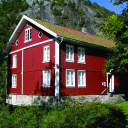
LocalitiesHasalvik Quarry, Bamble, Telemark, Norway
9th Jan 2018 12:47 UTCThe Evje og Hornnes geomuseum, Fennefoss Expert
Is there someone who is familiar with this locality?
I compared Andersen's (1931) drawing with a map on for instance kart.1881.no: https://kart.1881.no/?r=F4174219
You can find the map of Andersen here at page 9: http://www.ngu.no/filearchive/NGUPublikasjoner/NGUnr_128_B_Andersen_II.pdf
I just cannot get them to correspond...
Andersen's map is clearly different from how it should look like.
Or do I see it wrong?
The background for this question is that I am busy trying to get the exact (or as exact as possible) coordinates of all pegmatites described by Andersen etc.
BTW if the person who added bornite to the list of occurring minerals is reading this, please confirm that you found this mineral yourself or where did you read it?
Ronald Werner
Evje og Hornnes geomuseum Fennefoss
Norway
9th Jan 2018 14:45 UTCUwe Kolitsch Manager
https://www.mindat.org/locentry-179211.html
Andersen, O. (1931): Feltspat II. Forekomster i fylkene Buskerud og Telemark, i flere herreder i Aust-Agder og i Hidra i Vest-Agder. Norges Geologiske Undersøkelse 128b, p 8-10

9th Jan 2018 15:01 UTCPeter Andresen Expert
Peter

9th Jan 2018 17:03 UTCAlf Olav Larsen
I have recorded all pegmatite quarries in Telemark county and can give you exact data on each of them. Contact me on e-mail.
Alf Olav


Mindat.org is an outreach project of the Hudson Institute of Mineralogy, a 501(c)(3) not-for-profit organization.
Copyright © mindat.org and the Hudson Institute of Mineralogy 1993-2024, except where stated. Most political location boundaries are © OpenStreetMap contributors. Mindat.org relies on the contributions of thousands of members and supporters. Founded in 2000 by Jolyon Ralph.
Privacy Policy - Terms & Conditions - Contact Us / DMCA issues - Report a bug/vulnerability Current server date and time: May 5, 2024 23:00:45