Log InRegister
Quick Links : The Mindat ManualThe Rock H. Currier Digital LibraryMindat Newsletter [Free Download]
Home PageAbout MindatThe Mindat ManualHistory of MindatCopyright StatusWho We AreContact UsAdvertise on Mindat
Donate to MindatCorporate SponsorshipSponsor a PageSponsored PagesMindat AdvertisersAdvertise on Mindat
Learning CenterWhat is a mineral?The most common minerals on earthInformation for EducatorsMindat ArticlesThe ElementsThe Rock H. Currier Digital LibraryGeologic Time
Minerals by PropertiesMinerals by ChemistryAdvanced Locality SearchRandom MineralRandom LocalitySearch by minIDLocalities Near MeSearch ArticlesSearch GlossaryMore Search Options
Search For:
Mineral Name:
Locality Name:
Keyword(s):
 
The Mindat ManualAdd a New PhotoRate PhotosLocality Edit ReportCoordinate Completion ReportAdd Glossary Item
Mining CompaniesStatisticsUsersMineral MuseumsClubs & OrganizationsMineral Shows & EventsThe Mindat DirectoryDevice SettingsThe Mineral Quiz
Photo SearchPhoto GalleriesSearch by ColorNew Photos TodayNew Photos YesterdayMembers' Photo GalleriesPast Photo of the Day GalleryPhotography

Kim Macdonald's Photo Gallery

Nangaroo Copper Mine

02539740017056153993968.jpg
Nangaroo copper Mine, Eulaminna, Leonora Shire, Western Australia, Australia

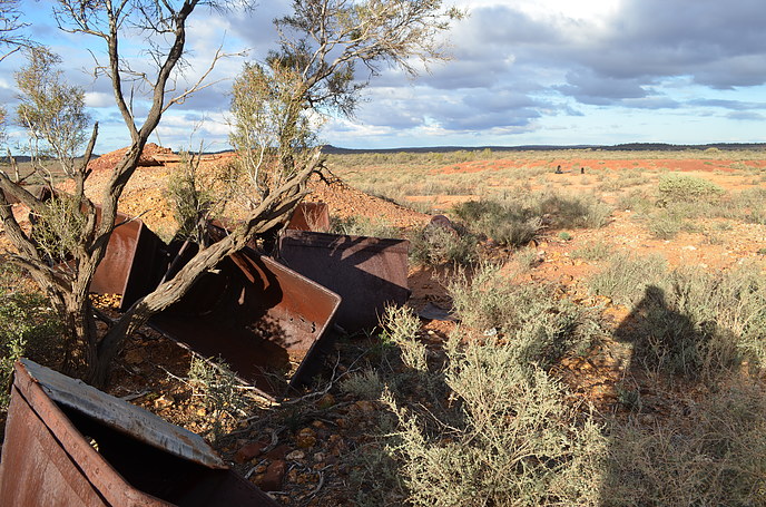
Skip bins lying around the Nangaroo Copper Mine. Developed by Isaac Matson in the early 1900's. At least the picture is taken from where we have marked the mine to be. Copper is a strong colouring agent, and I would have expected some trace at least of blue/green from the dregs remaining. Minor possibly herbertsmithite was located at the neighbouring Hill open pit, leading some credence we are in the right area.
Photo ID: 1155012     Uploaded by: Kim Macdonald   Upload date: 2021-07-19   View Count: 66    Status: Public galleries    Type: Photo - 4928×3264 (16.1 Mpix)

Hill Mine

07234930017055730169530.jpg
Hill Mine, Eulaminna, Leonora Shire, Western Australia, Australia

The mine was developed across 1906-1909 by W.C. Hill who made a fortune from the deposit. In modern times a small open pit has been developed at the site. Old tunnels can be seen in the far wall of the pit.
Photo ID: 1155011     Uploaded by: Kim Macdonald   Upload date: 2021-07-19   View Count: 39    Status: Public galleries    Type: Photo - 4928×3264 (16.1 Mpix)

King Street Gold Mine

07607180017055313526725.jpg
King Street Gold Mine, Mount Morgans Gold Mine, Mount Margaret Goldfield, Laverton Shire, Western Australia, Australia

The mine was arrived at accidently when I took a wrong turn out of the tourist area, and ended up on an internal mine road. Thankfully mining activity at the site had ceased many years ago. Mining companies and authorities discourage visitors to such sites, for fear people will fall into the pit.
Photo ID: 1155005     Uploaded by: Kim Macdonald   Upload date: 2021-07-19   View Count: 59    Status: Public galleries    Type: Photo - 4928×3264 (16.1 Mpix)

Geologist Camp

01814730017055313541829.jpg
Westralia Gold Mine, Mount Morgans Gold Mine, Mount Margaret Goldfield, Laverton Shire, Western Australia, Australia

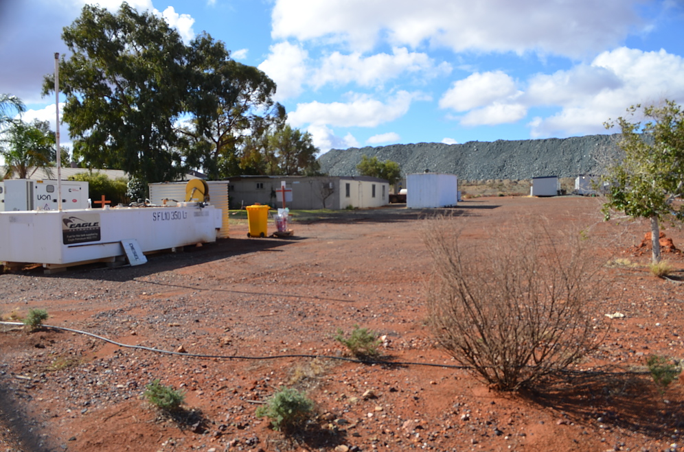
In the early 1900's Mount Morgan was a substantial town, and for a short time the Westralia Gold Mine next door one of the richest in the State. Now one building remains, the dated 1900 Municipal Chambers, which is available for tourists to view from the outside. The Westralia Mine is not. Conveniently, the present mining company has sited the geology camp next to the historic building, so tourists can gawk at them through the fence. Waste rock from the Westralia Mine is in the background.
Photo ID: 1155004     Uploaded by: Kim Macdonald   Upload date: 2021-07-19   View Count: 56    Status: Public galleries    Type: Photo - 4928×3264 (16.1 Mpix)

Eucalyptus Gold Mine

06872660017058309584333.jpg
Eucalyptus gold area, Yundamindera Goldfield, Leonora Shire, Western Australia, Australia

A visit in 2021 altered the perception of this location. Visible from the road is a compact area of shafts, which operated as a minor prospector field in the early 1900's. What is further off the road was not explored. Many small nuggets were said to be found in the area. There is banded jasper nearby, but tends to only come to life when wet.
Photo ID: 1155002     Uploaded by: Kim Macdonald   Upload date: 2021-07-19   View Count: 56    Status: Public galleries    Type: Photo - 4928×3264 (16.1 Mpix)

Red October Gold Mine

05468390017055698503325.jpg
Red October Gold Mine, Linden Goldfield, Leonora Shire, Western Australia, Australia

Photo ID: 1155001     Uploaded by: Kim Macdonald   Upload date: 2021-07-19   View Count: 46    Status: Public galleries    Type: Photo - 4928×3264 (16.1 Mpix)

Butcher Well Gold Mine

09035590017055698559854.jpg
Butcher Well Gold Mine, Linden Goldfield, Leonora Shire, Western Australia, Australia

Photo ID: 1154939     Uploaded by: Kim Macdonald   Upload date: 2021-07-18   View Count: 24    Status: Public galleries    Type: Photo - 4928×3264 (16.1 Mpix)

Second Fortune Gold Mine

04011420017055194924732.jpg
Second Fortune Gold Mine, Linden Goldfield, Leonora Shire, Western Australia, Australia

An impressive trench snakes its way between two shafts following a gold vein.
Photo ID: 1154938     Uploaded by: Kim Macdonald   Upload date: 2021-07-18   View Count: 47    Status: Public galleries    Type: Photo - 4928×3264 (16.1 Mpix)

Second Fortune Gold Mine

09176410017055698541271.jpg
Second Fortune Gold Mine, Linden Goldfield, Leonora Shire, Western Australia, Australia

The modern open pit was active again, or at least a company called LGA was occupying it when visited (2021). The picture is taken of workings a few hundred metres to the north on a low ridge by the Mount Celia Road. I am uncertain if the modern mine occupies the historic site, or is the one pictured. There were several shafts in a compact area, and in this photo also minor concrete foundations and a boiler.
Photo ID: 1154937     Uploaded by: Kim Macdonald   Upload date: 2021-07-18   View Count: 34    Status: Public galleries    Type: Photo - 4928×3264 (16.1 Mpix)

Kangaroo Bore Gold Mine

01976570017055194918097.jpg
Kangaroo Bore Gold Mine, Linden Goldfield, Leonora Shire, Western Australia, Australia

This unmarked location was some 50 metres off the Mt Celia Road. A low ridge contained a couple of shafts, a collapsed working, and modern trench cut through the ridge by an exploration company. A track heads south-west possibly to other shafts, however was not explored for fear of encountering a drilling crew (recent wheel tracks could be seen, and the ubiquitous plastic bags of their activity).
Photo ID: 1154936     Uploaded by: Kim Macdonald   Upload date: 2021-07-18   View Count: 34    Status: Public galleries    Type: Photo - 4928×3264 (16.1 Mpix)
Page 1 of 11 (1 to 10 of 108 total)
1 2 3 4 5 6 7 8 9 10 11
 
and/or  
Mindat Discussions Facebook Logo Instagram Logo Discord Logo
Mindat.org is an outreach project of the Hudson Institute of Mineralogy, a 501(c)(3) not-for-profit organization.
Copyright © mindat.org and the Hudson Institute of Mineralogy 1993-2024, except where stated. Most political location boundaries are © OpenStreetMap contributors. Mindat.org relies on the contributions of thousands of members and supporters. Founded in 2000 by Jolyon Ralph.
Privacy Policy - Terms & Conditions - Contact Us / DMCA issues - Report a bug/vulnerability Current server date and time: May 5, 2024 01:41:00
Go to top of page