Log InRegister
Quick Links : The Mindat ManualThe Rock H. Currier Digital LibraryMindat Newsletter [Free Download]
Home PageAbout MindatThe Mindat ManualHistory of MindatCopyright StatusWho We AreContact UsAdvertise on Mindat
Donate to MindatCorporate SponsorshipSponsor a PageSponsored PagesMindat AdvertisersAdvertise on Mindat
Learning CenterWhat is a mineral?The most common minerals on earthInformation for EducatorsMindat ArticlesThe ElementsThe Rock H. Currier Digital LibraryGeologic Time
Minerals by PropertiesMinerals by ChemistryAdvanced Locality SearchRandom MineralRandom LocalitySearch by minIDLocalities Near MeSearch ArticlesSearch GlossaryMore Search Options
Search For:
Mineral Name:
Locality Name:
Keyword(s):
 
The Mindat ManualAdd a New PhotoRate PhotosLocality Edit ReportCoordinate Completion ReportAdd Glossary Item
Mining CompaniesStatisticsUsersMineral MuseumsClubs & OrganizationsMineral Shows & EventsThe Mindat DirectoryDevice SettingsThe Mineral Quiz
Photo SearchPhoto GalleriesSearch by ColorNew Photos TodayNew Photos YesterdayMembers' Photo GalleriesPast Photo of the Day GalleryPhotography

Frank L. Murray's Photo Gallery

Spar Hill Fluorite Mine New Mexico USA

09291120014946610935988.jpg
Spar Hill Prospect, West Burro Mountains, Burro Mountains Mining District, Grant County, New Mexico, USA

Spar Hill Fluorite Mine, photo taken November 2005. The pick is pointing to a vein of blue fluorite under the small ledge. The under ground mine is not accessible. Fluorite specimens can still be found on the mine dumps, and in the vein shown in the picture.
Photo ID: 199202     Uploaded by: Frank L. Murray   Upload date: 2008-12-03   View Count: 892    Status: Public galleries    Type: Photo - 2032×1524 (3.1 Mpix)

Spar Hill Fluorite Mine, New Mexico USA

05603370014946610905951.jpg
Spar Hill Prospect, West Burro Mountains, Burro Mountains Mining District, Grant County, New Mexico, USA

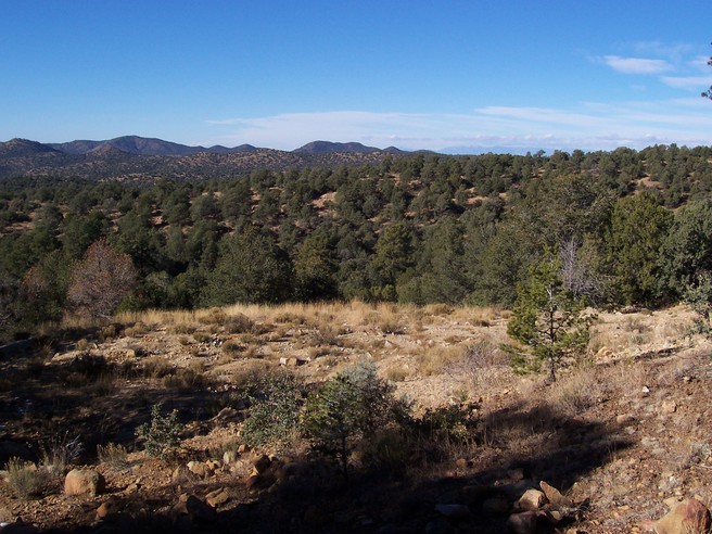
Spar Hill Fluorite Mine located about 1/2 mile north east of Pine Canyon Fluorite Prospect, photo taken November 2005. The vertical mine shaft, behind the trees, is inaccessible.
Photo ID: 199201     Uploaded by: Frank L. Murray   Upload date: 2008-12-03   View Count: 635    Status: Public galleries    Type: Photo - 2032×1524 (3.1 Mpix)

Pine Canyon Fluorite Deposit New Mexico USA

08360590014946288844261.jpg
Judith Lynn Claim, Pine Canyon deposit, West Burro Mountains, Burro Mountains Mining District, Grant County, New Mexico, USA

Pine Canyon Fluorite Deposit, AKA Judith Lynn Claim, photo taken November 2004. The site has been reclaimed as seen in the photo. Occasional Fluorite specimens can still be found on the surface. They are covered with a layer of quartz that can be removed in an acid bath.
Photo ID: 199176     Uploaded by: Frank L. Murray   Upload date: 2008-12-03   View Count: 833    Status: Public galleries    Type: Photo - 2032×1524 (3.1 Mpix)

66C-6UVTektite

Multiple photos available
05461250014948218727316.jpg
Walker County, Texas, USA

Tektite, Bediasite close up 15X, specimen is 2 cm long. Collected 1996 and photo by Frank L. Murray.
Copyright: © F L Murray      Photo ID: 158179     Uploaded by: Frank L. Murray   Upload date: 2008-03-24   View Count: 858    Status: Public galleries    Type: Photo - 1979×1218 (2.4 Mpix)

QG7-W8ESpangolite Cu6Al(SO4)(OH)12Cl·3H2O , Brochantite Cu4(SO4)(OH)6 , Baryte BaSO4

Multiple photos available
08591970014951229791063.jpg
Bingham, Hansonburg District, Socorro County, New Mexico, USA

Blue Spangolite, Green Brochantite, on White Barite matrix, specimen 13 cm.
Photo by Frank L. Murray.
Copyright: © F L Murray      Photo ID: 158172     Uploaded by: Frank L. Murray   Upload date: 2008-03-24   View Count: 554    Status: Public galleries    Type: Photo - 2032×1354 (2.8 Mpix)

GQT-KQJHelvine Be3Mn2+4(SiO4)3S

02217390014950667381675.jpg
Victorio District, Victorio Mountains, Luna County, New Mexico, USA

Honey colored tetrahedrons of Helvite, FOV 5 mm. Collected 1992 and photo by Frank L. Murray.
Copyright: © F. L. Murray      Photo ID: 156742     Uploaded by: Frank L. Murray   Upload date: 2008-03-17   View Count: 452    Status: Public galleries    Type: Photo - 1037×691 (0.7 Mpix)

RDQ-XFAChabazite

02196900014947505425944.jpg
Alum Mountain Mining District, Grant County, New Mexico, USA

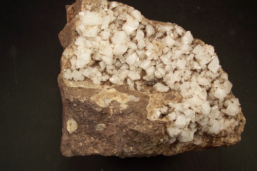
White rhombs of Chabazite from East Fork of the Gila River, specimen 12 cm. Photo by Frank L. Murray.
Copyright: © F L Murray      Photo ID: 156741     Uploaded by: Frank L. Murray   Upload date: 2008-03-17   View Count: 420    Status: Public galleries    Type: Photo - 2032×1354 (2.8 Mpix)

21P-95NChalcopyrite CuFeS2 , Calcite CaCO3

08311200014947015947747.jpg
San Pedro Mine, New Placers District, Santa Fe County, New Mexico, USA

Chalcopyrite altering to green Malachite with white Calcite, specimen 6 cm. Photo by Frank L. Murray
Copyright: © F L Murray      Photo ID: 156740     Uploaded by: Frank L. Murray   Upload date: 2008-03-17   View Count: 523    Status: Public galleries    Type: Photo - 2032×1354 (2.8 Mpix)

ANM-LVFPyrolusite Mn4+O2

09914040014957517602331.jpg
Lake Valley Mining District, Sierra County, New Mexico, USA

Black Pyrolusite needlelike crystals, specimen 8 cm. Photo by Frank L, Murray
Copyright: © F. L. Murray      Photo ID: 156739     Uploaded by: Frank L. Murray   Upload date: 2008-03-17   View Count: 503    Status: Public galleries    Type: Photo - 2032×1354 (2.8 Mpix)

LAK-YK7Smithsonite ZnCO3

02246890014957517618034.jpg
Enterprise tunnel, Magdalena Mining District, Socorro County, New Mexico, USA

Smithsonite white rice grain, specimen 8 cm. Photo by Frank L. Murray
Copyright: © F L Murray      Photo ID: 156738     Uploaded by: Frank L. Murray   Upload date: 2008-03-17   View Count: 528    Status: Public galleries    Type: Photo - 2032×1354 (2.8 Mpix)
Page 1 of 20 (1 to 10 of 199 total)
1 2 3 4 5 6 7 8 9 10 11 12 13 14 15 16 17 ...
 
Mineral and/or Locality  
Mindat Discussions Facebook Logo Instagram Logo Discord Logo
Mindat.org is an outreach project of the Hudson Institute of Mineralogy, a 501(c)(3) not-for-profit organization.
Copyright © mindat.org and the Hudson Institute of Mineralogy 1993-2024, except where stated. Most political location boundaries are © OpenStreetMap contributors. Mindat.org relies on the contributions of thousands of members and supporters. Founded in 2000 by Jolyon Ralph.
Privacy Policy - Terms & Conditions - Contact Us / DMCA issues - Report a bug/vulnerability Current server date and time: April 27, 2024 01:33:49
Go to top of page