Serra dos Monges No. 1 Mine, Santiago do Escoural, Montemor-o-Novo, Évora, Portugali
| Regional Level Types | |
|---|---|
| Serra dos Monges No. 1 Mine | Mine (Disused) |
| Santiago do Escoural | Civil Parish |
| Montemor-o-Novo | Municipality |
| Évora | District |
| Portugal | Country |
This page is currently not sponsored. Click here to sponsor this page.


Latitude & Longitude (WGS84):
38° 34' 26'' North , 8° 11' 35'' West
Latitude & Longitude (decimal):
Type:
Mine (Disused) - last checked 2023
Köppen climate type:
Nearest Settlements:
| Place | Population | Distance |
|---|---|---|
| Montemor-o-Novo | 12,854 (2014) | 8.5km |
| Évora | 55,620 (2018) | 25.5km |
| Vendas Novas | 11,248 (2014) | 25.7km |
| Alcácer do Sal | 9,198 (2014) | 35.8km |
| Alvito | 2,504 (2018) | 39.4km |
Mindat Locality ID:
109204
Long-form identifier:
mindat:1:2:109204:5
GUID (UUID V4):
7074d087-db09-4b6f-8b23-9460400908d3
Name(s) in local language(s):
Mina da Serra dos Monges no. 1, Santiago do Escoural, Montemor-o-Novo, Distrito de Évora, Portugal
Ancient Fe mine.
Mining concession no. 31 Serra dos Monges no. 1 (Fe), registered on 22-04-1867.
Geologia da Ocorrência:
Tipos: Ocorrências de Ferro - Ligadas a processos metamórficos - Estratiformes, Ocorrências de Ferro - Ligadas a vulcanismo - Estratiformes
Descrição Geológica: Estruturas estratiformes de: magnetite compacta; magnetite granular disseminada em ganga anfibolo-asbéstica; magnetite com pirite de aspecto compacto e com ganga silicioso-calcária; hematite. Observa-se magnetite secundária, resultante de oxidação da pirite. Existem ainda mineralizações de sulfuretos disseminados, pirite - pirrotite - calcopirite, em vulcanitos intermédios - básicos.
Mineralizações Principais: Hematite (Oligisto), Magnetite (Ferro magnético), Pirite
Morfologias: Estratiforme, Lenticular
Rochas Encaixantes: Anfibolitos, Calcários, Xistos
Geologia Local: Formação do Escoural (Proterozóico). Calcários cristalinos (Câmbrico). Vulcanitos (Ordovícico-Silúrico).
Geologia Regional: Proterozóico superior. Câmbrico. Ordovícico. Silúrico
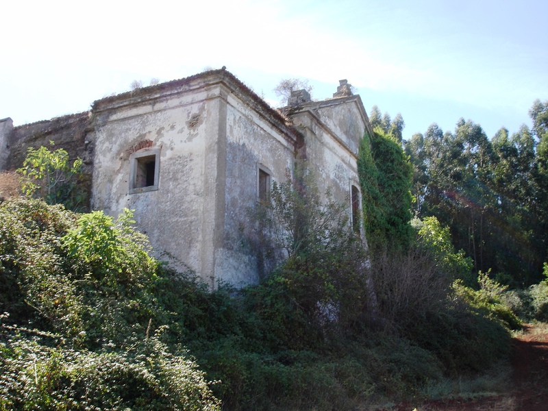
A concessão Serra dos Monges Nº 1, conhecida vulgarmente por Mina dos Monges, deve o seu nome ao facto de existir dentro da concessão e muito perto dos trabalhos da Ermida, o Convento dos Ermitas Descalços de S. Paulo, de Nossa Senhora do Castelo ou das Covas de Monfurado. Primeiramente, em 1710, os monges viveram em covas subterrâneas ou grutas, possívelmente resultantes de primitivas lavras executadas pelos Romanos e Mouros, até que em 1738 foi construído o Convento que, depois de abandonado, provávelmente em 1834 quando da extinção de todas as Ordens de Religiosos, por Decreto de Joaquim António de Aguiar (28 de Maio de 1834), serviu mais tarde, depois de reparado, para alojamento de parte do pessoal empregado na mina.
A Mina dos Monges foi a primeira a ser concedida, só para ferro em Portugal.
O primeiro manifesto é de 6 de Março de 1857 por D. Alexandre Botelho e seu filho e do qual não deu origem a concessão. Ao longo dos anos a concessão foi passando por várias entidades, as quais desenvolveram trabalhos de corta e de galerias de NW para SE do Convento com explorações distintas:
Trabalhos da Ermida, Trabalhos de S. Jorge, Trabalhos D. Maria, Trabalhos do Filão Street, Trabalhos da Pirâmede, Trabalhos do Filão Barbosa e Trabalhos das Águas. A ultima entidade a suspender a exploração foi o Banco Burnay em 29 de Junho de 1937.
Geology of the Occurrence:
Types: Iron Occurrences - Metamorphic Processes Related - Stratiform, Iron Occurrences - Volcanism Related - Stratiform
Geological Description: Stratiform structures of compact magnetite; disseminated granular magnetite in amphibole-asbestos gangue; magnetite with compact pyrite and siliceous-calcareous gangue; hematite. Secondary magnetite resulting from pyrite oxidation is observed. There are also disseminated sulfide mineralizations, pyrite - pyrrhotite - chalcopyrite, in intermediate to basic volcanic rocks.
Main Mineralizations: Hematite (Oligiste), Magnetite (Magnetic Iron), Pyrite
Morphologies: Stratiform, Lenticular
Host Rocks: Amphibolites, Limestone, Shales
Local Geology: Escoural Formation (Proterozoic). Crystalline Limestones (Cambrian). Volcanic Rocks (Ordovician-Silurian).
Regional Geology: Upper Proterozoic. Cambrian. Ordovician. Silurian.
The Serra dos Monges No. 1 concession, commonly known as Mina dos Monges, owes its name to the fact that within the concession and very close to the Ermida works, there is the Convent of the Barefoot Hermits of St. Paul, of Our Lady of the Castle or of Covas de Monfurado. Initially, in 1710, the monks lived in underground caves, possibly resulting from primitive mining activities carried out by the Romans and Moors until the construction of the Convent in 1738. After being abandoned, probably around 1834 when all Religious Orders were abolished by the decree of Joaquim António de Aguiar (May 28, 1834), it was later repaired and used as housing for part of the personnel employed in the mine.
Mina dos Monges was the first concession exclusively for iron in Portugal.
The first manifesto was on March 6, 1857, by D. Alexandre Botelho and his son, which did not lead to a concession. Over the years, the concession passed through various entities, which carried out cutting and gallery works from NW to SE of the Convent, with distinct explorations:
Ermida Works, S. Jorge Works, D. Maria Works, Filão Street Works, Pirâmede Works, Filão Barbosa Works, and Águas Works. The last entity to suspend operations was Banco Burnay on June 29, 1937.
Monfurado (serra e herdade de)
Nome originado em Monte Furado, elevação atravessada por galerias, as quais, neste caso, resultaram da exploração de ferro na época romana. O pároco do Escoural José da Cunha e Silva afirmou, na sua memória de 1758, provir esse nome «de se verem na mesma serra muitas covas e algumas que atravessam por baixo dela». Nos começos do século XVIII alguns eremitas começaram a viver nessas cavidades, tendo tal experiência religiosa resultado na fundação da Congregação dos Monges das Covas de Monfurado, que seguiam a regra de São Paulo da Serra de Ossa, assim como na construção do respetivo convento. No século XIX foi retomada a atividade mineira, que destruiu os vestígios anteriores.
Monfurado
The name originated from "Monte Furado," a hill traversed by galleries which, in this case, resulted from iron mining during the Roman era. The parish priest of Escoural, José da Cunha e Silva, stated in his memoir of 1758 that the name derived "from the observation of many caves on the same mountain, with some passing underneath it." In the early 18th century, some hermits began to inhabit these cavities, and this religious experience led to the foundation of the Congregation of Monks of Monfurado Caves. They followed the rule of São Paulo from Serra de Ossa and built their respective convent. In the 19th century, mining activity was resumed, which destroyed the previous traces.
In: montemorbase.com/noticia/toponimos-rurais-de-montemor-o-novo
Select Mineral List Type
Standard Detailed Gallery Strunz Chemical ElementsDetailed Mineral List:
| ⓘ Chalcopyrite Formula: CuFeS2 References: |
| ⓘ Copiapite Formula: Fe2+Fe3+4(SO4)6(OH)2 · 20H2O References: Rui Nunes' visit in April 2024Identified by Rui Nunes: Visual Identification |
| ⓘ Hematite Formula: Fe2O3 References: |
| ⓘ 'Limonite' References: |
| ⓘ Magnetite Formula: Fe2+Fe3+2O4 References: |
| ⓘ Melanterite Formula: Fe2+(H2O)6SO4 · H2O References: Rui Nunes' visit in April 2024Identified by Rui Nunes: Visual Identification |
| ⓘ Muscovite Formula: KAl2(AlSi3O10)(OH)2 References: |
| ⓘ Pyrite Formula: FeS2 References: |

List of minerals arranged by Strunz 10th Edition classification
| Group 2 - Sulphides and Sulfosalts | |||
|---|---|---|---|
| ⓘ | Chalcopyrite | 2.CB.10a | CuFeS2 |
| ⓘ | Pyrite | 2.EB.05a | FeS2 |
| Group 4 - Oxides and Hydroxides | |||
| ⓘ | Magnetite | 4.BB.05 | Fe2+Fe3+2O4 |
| ⓘ | Hematite | 4.CB.05 | Fe2O3 |
| Group 7 - Sulphates, Chromates, Molybdates and Tungstates | |||
| ⓘ | Melanterite | 7.CB.35 | Fe2+(H2O)6SO4 · H2O |
| ⓘ | Copiapite | 7.DB.35 | Fe2+Fe3+4(SO4)6(OH)2 · 20H2O |
| Group 9 - Silicates | |||
| ⓘ | Muscovite | 9.EC.15 | KAl2(AlSi3O10)(OH)2 |
| Unclassified | |||
| ⓘ | 'Limonite' | - | |
List of minerals for each chemical element
| H | Hydrogen | |
|---|---|---|
| H | ⓘ Copiapite | Fe2+Fe43+(SO4)6(OH)2 · 20H2O |
| H | ⓘ Melanterite | Fe2+(H2O)6SO4 · H2O |
| H | ⓘ Muscovite | KAl2(AlSi3O10)(OH)2 |
| O | Oxygen | |
| O | ⓘ Copiapite | Fe2+Fe43+(SO4)6(OH)2 · 20H2O |
| O | ⓘ Hematite | Fe2O3 |
| O | ⓘ Magnetite | Fe2+Fe23+O4 |
| O | ⓘ Melanterite | Fe2+(H2O)6SO4 · H2O |
| O | ⓘ Muscovite | KAl2(AlSi3O10)(OH)2 |
| Al | Aluminium | |
| Al | ⓘ Muscovite | KAl2(AlSi3O10)(OH)2 |
| Si | Silicon | |
| Si | ⓘ Muscovite | KAl2(AlSi3O10)(OH)2 |
| S | Sulfur | |
| S | ⓘ Chalcopyrite | CuFeS2 |
| S | ⓘ Copiapite | Fe2+Fe43+(SO4)6(OH)2 · 20H2O |
| S | ⓘ Melanterite | Fe2+(H2O)6SO4 · H2O |
| S | ⓘ Pyrite | FeS2 |
| K | Potassium | |
| K | ⓘ Muscovite | KAl2(AlSi3O10)(OH)2 |
| Fe | Iron | |
| Fe | ⓘ Chalcopyrite | CuFeS2 |
| Fe | ⓘ Copiapite | Fe2+Fe43+(SO4)6(OH)2 · 20H2O |
| Fe | ⓘ Hematite | Fe2O3 |
| Fe | ⓘ Magnetite | Fe2+Fe23+O4 |
| Fe | ⓘ Melanterite | Fe2+(H2O)6SO4 · H2O |
| Fe | ⓘ Pyrite | FeS2 |
| Cu | Copper | |
| Cu | ⓘ Chalcopyrite | CuFeS2 |
Other Regions, Features and Areas containing this locality
This page contains all mineral locality references listed on mindat.org. This does not claim to be a complete list. If you know of more minerals from this site, please register so you can add to our database. This locality information is for reference purposes only. You should never attempt to
visit any sites listed in mindat.org without first ensuring that you have the permission of the land and/or mineral rights holders
for access and that you are aware of all safety precautions necessary.
References


Serra dos Monges No. 1 Mine, Santiago do Escoural, Montemor-o-Novo, Évora, Portugal