| Locality type: | Mine |
| Classification |
|---|
|
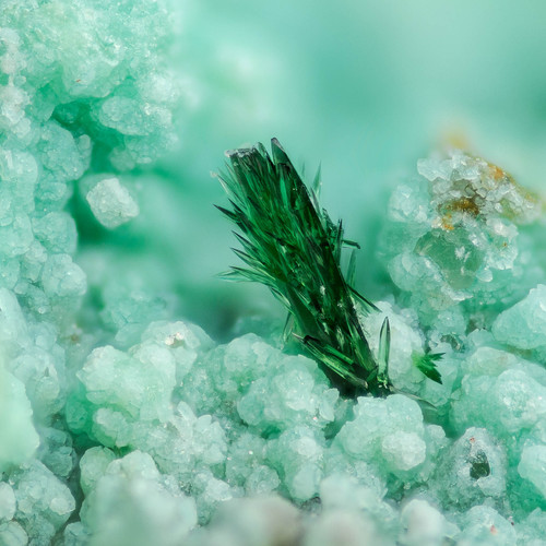
| Species: | Libethenite |
| Formula: | Cu2(PO4)(OH) |
| Confirmation |
|---|
|
| Validity: | Believed Valid |
| Associated Minerals Based on Photo Data: |
|---|
|
| Chrysocolla | ⓘ5 photos of Libethenite associated with Chrysocolla at this locality. |
| Allophane | ⓘ3 photos of Libethenite associated with Allophane at this locality. |
| Schorl | ⓘ2 photos of Libethenite associated with Schorl at this locality. |
| Tenorite | ⓘ2 photos of Libethenite associated with Tenorite at this locality. |
| Muscovite | ⓘ2 photos of Libethenite associated with Muscovite at this locality. |
| Torbernite | ⓘ1 photo of Libethenite associated with Torbernite at this locality. |
| Rutile | ⓘ1 photo of Libethenite associated with Rutile at this locality. |
| Chlorite Group | ⓘ1 photo of Libethenite associated with Chlorite Group at this locality. |
| Data |
|---|
|
| Mineral Data: | Click here to view Libethenite data |
| Locality Data: | Click here to view Old Reliable Mine (Reliable Mine; Calumet Mine; Clark-Scanlon group; Copper Creek Mining Co. property), Copper Creek (Copper Creek Canyon), Bunker Hill District (Copper Creek District), Pinal County, Arizona, USA |
| Photo Gallery | View Gallery (39 photos) |
| Data Identifiers |
|---|
|
| Mindat Occurrence Record ID: | 246068 |
| Long-form Identifier: | 1:3:246068:0 |
| GUID (UUID V4): | eca5ef06-4dcc-47a9-a4cb-fdd48cc0ad06 |
| Nearest other occurrences of Libethenite |
|---|
|
|
| 46.1km (28.7 miles) | ⓘ79 Mine, Chilito, Hayden area, Banner Mining District, Gila County, Arizona, USA |
| 64.2km (39.9 miles) | ⓘRay Mine, Scott Mountain, Pinal County, Arizona, USA |
| 67.5km (41.9 miles) | ⓘRay, Pinal County, Arizona, USA |
| 82.2km (51.1 miles) | ⓘJohnson Mine (Johnson Camp Mine), Johnson Camp, Gunnison Copper Project, Cochise Mining District, Cochise County, Arizona, USA |
| 82.4km (51.2 miles) | ⓘJohnson Camp, Gunnison Copper Project, Cochise Mining District, Cochise County, Arizona, USA |
| 82.4km (51.2 miles) | ⓘInspiration pit, Inspiration Mine, Miami-Inspiration deposit, Inspiration, Miami-Inspiration Mining District, Globe-Miami Mining District, Gila County, Arizona, USA |
| 84.9km (52.7 miles) | ⓘCastle Dome Mine (Castle Dome deposit; Pinto Valley deposit), Castle Dome area (Castle Dome Mine area; Pinto Valley Mine area), Inspiration, Miami-Inspiration Mining District, Globe-Miami Mining District, Gila County, Arizona, USA |
| 87.5km (54.4 miles) | ⓘSaginaw Hill (Saginaw property), Amole Mining District, Tucson Mountains, Pima County, Arizona, USA |
| 98.9km (61.5 miles) | ⓘChief Mine (Chief claim), Prince Mine group, Hilton Mines, Copper Camp, Hilton (Lead Mountain), Empire Mining District, Empire Mountains, Pima County, Arizona, USA |
| References |
|---|
|
|


Old Reliable Mine, Copper Creek, Bunker Hill District, Pinal County, Arizona, USA