| Locality type: | Quarry |
| Classification |
|---|
|
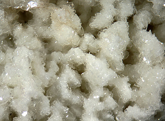
| Species: | Datolite |
| Formula: | CaB(SiO4)(OH) |
| Comments: | Present mostly as white, granular replacement of earlier chalcedony, grading to 2 mm tabular crystals or druses. Much of it replaced by prehnite. |
| Habit: | massive, granular, to small glassy crystals |
| Colour: | white to pale apple green |
| Quality for species: | Poor for species, only of interest for locality collectors. (#) |
| Abundance at site: | Common |
| Confirmation |
|---|
|
| Validity: | Confirmed |
| Confirmation Methods: | Visually Identified |
| Associated Minerals Based on Photo Data: |
|---|
|
| Prehnite | ⓘ20 photos of Datolite associated with Prehnite at this locality. |
| Calcite | ⓘ4 photos of Datolite associated with Calcite at this locality. |
| Pumpellyite Group | ⓘ4 photos of Datolite associated with Pumpellyite Group at this locality. |
| Fluorapophyllite-(K) | ⓘ3 photos of Datolite associated with Fluorapophyllite-(K) at this locality. |
| Pyrite | ⓘ2 photos of Datolite associated with Pyrite at this locality. |
| Anhydrite | ⓘ2 photos of Datolite associated with Anhydrite at this locality. |
| Quartz | ⓘ2 photos of Datolite associated with Quartz at this locality. |
| Hematite | ⓘ1 photo of Datolite associated with Hematite at this locality. |
| Sphalerite | ⓘ1 photo of Datolite associated with Sphalerite at this locality. |
| Data |
|---|
|
| Mineral Data: | Click here to view Datolite data |
| Locality Data: | Click here to view O & G Southbury Quarry (Silliman Quarry; O & G No. 2 Quarry), Orenaug Hills, Woodbury, Litchfield County, Connecticut, USA |
| Photo Gallery | View Gallery (11 photos) |
| Data Identifiers |
|---|
|
| Mindat Occurrence Record ID: | 657168 |
| Long-form Identifier: | 1:3:657168:9 |
| GUID (UUID V4): | 4cb3f320-099f-461e-b00f-370d368da893 |
| Nearest other occurrences of Datolite |
|---|
|
|
| 3.6km (2.2 miles) | ⓘO & G Woodbury Traprock Quarry (Orenaug Quarry; O & G No. 1 Quarry), Orenaug Hills, Woodbury, Litchfield County, Connecticut, USA |
| 16.5km (10.2 miles) | ⓘU. S. Route 7 Expressway (Danbury line to Iron Works District), Brookfield, Fairfield County, Connecticut, USA |
| 23.0km (14.3 miles) | ⓘRoaring Brook, Cheshire, New Haven County, Connecticut, USA |
| 23.0km (14.3 miles) | ⓘNorth Street mall, Danbury, Fairfield County, Connecticut, USA |
| 23.8km (14.8 miles) | ⓘThomaston Dam railroad cut, Thomaston Dam, Thomaston, Litchfield County, Connecticut, USA |
| 24.3km (15.1 miles) | ⓘCheshire Traprock Quarry, Cheshire, New Haven County, Connecticut, USA |
| 27.5km (17.1 miles) | ⓘInterstate 691 and State Route 10 Interchange, Cheshire, New Haven County, Connecticut, USA |
| 32.5km (20.2 miles) | ⓘHubbard Park Quartz locality, Meriden, New Haven County, Connecticut, USA |
| 33.6km (20.9 miles) | ⓘPillow lava locality, Meriden, New Haven County, Connecticut, USA |
| 35.4km (22.0 miles) | ⓘMeriden Trap Rock Quarry (Lane's Quarry), Meriden, New Haven County, Connecticut, USA |
| References |
|---|
|
|


O & G Southbury Quarry, Orenaug Hills, Woodbury, Litchfield County, Connecticut, USA