 | | Report (volume) |
| GfiOIJOGF Mineral Resources of the Wilson Mountains Primitive Area, Colorado By CALVIN S. BROMFIELD, U.S. GEOLOGICAL...a mineral survey of the Wilson Mountains Primitive Area and vicinity, Colorado. This bulletin is one of...___________________________________ Trout Lake mining district________.._____________-___-----_San Bernardo...prospects______________________-____-----------Mount Wilson mining district________-----------_-_-_------Silver...Basin area.___._________________---_--__-_Morning Star mine.____________________-_---_----Magpie mine____ |
 | | Report (volume) |
| Geology of the Mount Wilson Quadrangle Western San Juan Mountains Colorado By CALVIN S. BROMFIELD ...Tertiary_ _ _ _ ___ ____________ __ __ _____ _____ San Juan Formation___________________________________...Inclusions________________________________________________ Wilson Peak and Ophir stocks___________________________________...major intrusive rocks to igneous rocks of western San Juan Mountains_____________________________________...________ __ _____ ________ Geologic setting of Mount Wilson quadrangle______________________ Igneous intrusions |
 | | Book |
| URANIUM GUIDEBOOK FOR THE PARADOX BASIN, UTAH AND COLORADO TABLE OF CONTENTS Page THE PARADOX BASIN OVERVIEW...AND MINING AREAS SLICK ROCK DISTRICT GYPSUM VALLEY DISTRICT BULL CANYON DISTRICT URAVAN DISTRICT GATEWAY...GATEWAY DISTRICT (EASTERN GATEWAY AREA) MC ELMO CREEK DRAINAGE AREA LA SAL CREEK AREA PARADOX DISTRICT BEAVER...VALLEY (BIG INDIAN) DISTRICT MOAB DISTRICT GREEN RIVER DISTRICT THOMPSONS DISTRICT INTER-RIVER REGION...REGION DRY VALLEY DISTRICT COTTONWOOD AND BUTLER WASH AREAS MONTEZUMA CANYON DISTRICT SEVEN-MILE CANYON |
 | | Report (issue) |
| 1 COUNTY REPORT HYSICAL >ci 8 PHYSICAL •CI. .Lib. IES TN 24 C3 1ERAL RESOURCES OF A34 1 IPINE...IPINE COUNTY, CA! IA -*ci?2®^?^a£~Vfes^A^Gw^i I ver Mou nta i nV-*- Digitized by the Internet...ALPINE COUNTY, CALIFORNIA by WILLIAM B.CLARK With sections on the Zaca gold-silver mine and the...the Leviathan COUNTY REPORT sulfur mine by James R. Evans 8 1977 CALIFORNIA DIVISION OF MINES AND...2 i DOCS. -US Frontispiece. Typical Alpine County scenery. View looking southeast across Twin Lakes |
 | | Journal (issue) |
| Tucson, Arizona 85741 Editor & Publisher Wendell E. Wilson Founder John Sampson White Associate Editors Pierre...Correspondent Thomas Moore Editing, advertising Wendell E. Wilson 4631 Paseo Tubutama Tucson, AZ 85715 602-299-5274...Grice Famous mineral localities: the Mashamba West mine, Shaba, Zaire .................................... J. Gauthier & V. T. King The Fat Jack mine, Yavapai County, Arizona .................................& L. Wagner, Jr. The Monitor-Mogul mining district, Alpine County, California ...................... |
 | | Report (issue) |
| . . . . . . . . . . . . . . . . . 1 Chapter I. Mining Districts of Counties and the State of Utah. .... . . . . . . . . . . . . . . . . . . . . . . 1 County Listings. . . . . . . . . . . . . . . . . . . ... . . . . . . . . . . . . . . . . 1 Chapter II. Mining Districts of Utah . . . . . . . . . . . . . . .... . . . . . . . 4 Mineral Localities Listed by County . . . . . . . . . . . . . . . . . . . . . . . .... . . . . . . . . . . . . . . . . . . 7 Beaver County . . . . . . . . . . . . . . . . . . . . . . . |
 | | Report (issue) |
| Smith. Director Professional Paper 138 MINING IN COLORADO A HISTORY OF DISCOVERY, DEVELOPMENT AND PRODUCTJON...location, area, and organization of the mining counties of Colorado _________________________ _ Adams County_-..._____________________ _ Alamosa County __________________________ _ Arapahoe County _________________________...Archuleta County _________________________ _ Baca CountY-----------------------------Boulder CountY------...CountY----------------------~----Chaffee County _____________________·______ _ Clear Creek County _______________________ |
 | | Book |
| 1-:XXV 1970-1994 by Edwin L. Clopton Wendell E. Wilson THE MINERALOGICAL TUCSON 1995 RECORD The Mineralogical...community well for many decades to come. Wendell E. Wilson Tucson May 24, 1995 5 KEY TO ABBREVIATIONS ...193-256 137-208 129-192 209-264 193-256 [ [ COLORADO-Ill] 177-256 121-184 89-168 1-120 1-88 [ ...177-256 185-280 169-248 [ 425-528 337--400 COLORADO-II] 321--400 337--400 ARIZONA-Ill] 337--400...69-132 65-128 1-64 11 / 1980 20 I 1989 [ COLORADO-I] [ 289-352 385-448 [ AUSTRALlA] 353-504 |
 | | Report (issue) |
| Oxidized Zinc Deposits of the United States Part 3. Colorado By ALLEN V. HEYL GEOLOGICAL SURVEY BULLETIN...deposits and the resources of oxidized zin.c ores in Colorado UNITED STATES· GOVERNMENT PRINTING OFFICE, WASHINGTON...19180xidized zinc deposits of the United States. Part 3. Colorado. Washington, U.S. Govt. Print. Off., 1964. vi...Bibliography : p. 88-91. 1. Zinc ores-Colorado. 2. Zinc mines and mining-Colorado. I. Title. (Series) For sale...__ ___ __ __ __ __ __ _____ Kokomo (Ten ~ile) district _______ ._________________________ Breckenridge |
 | | Journal (article/letter/editorial) |
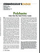
| [Northeastern University] at 11:57 17 November 2014 Husky Mine, Elsa, Yukon Territory, Canada T he ruby silvers...have been available in recent years from the Husky mine, Yukon Territory, Canada. Consequently, in keeping...this year’s Tucson Gem and Mineral Show, a Husky mine polybasite has been nominated as this issue’s Connoisseur’s...Cu)16(As,Sb)2S11. Pseudomorphs of stephanite, silver, pyrite, and marcasite after polybasite have been reported...of the more interesting Colorado occurrences include mines of Clear Creek County, particularly in the Georgetown |
 | | Journal (issue) |
| CA 9 2 6 5 2 . Editor & Publisher Wendell E. Wilson Associate Editors Pierre Bariand Sorbonne Paris...Michael P. Cooper Editing, advertising Wendell E, Wilson 4631 Paseo Tubutama Tucson, AZ 85715 602-299-5274...Famous mineral localities: The Rush Creek District, Marion County, Arkansas ...............................CHALCOPYRITE on TETRAHEDRITE, 15 cm, from the Herodsfoot mine, Liskeard, Cornwall, England. Collection of the...appointment only): 12068 East Am herst Place, Aurora, Colorado 80014, telephone/fax (303) 368-7497. The M ineralogical |
 | | Report (volume) |
| ............................................. Colorado........................................................................................ 102 District of Columbia ....................................to refer to Geological Survey Bulletin 507, "The mining districts of the western United States," and to...abundant it may have been completely exhausted by mining or quarrying. Deposits of minerals that are widely...because they occur in sufficient quantity to warrant mining for their usual products, but because they furnish |
 | | Report (volume) |
| General Geology of the Mammoth Quadrangle Pinal County, Arizona By S. C. CREASEY GEOLOGICAL SURVEY ...(Mammoth) mine_______________ _______ ____________ San Manuel deposit____________________________________________...Maudinarnine____________________________________________ Morning Star mine________________________________________..._ In pocket 2. Geologic maps of Maudina and Morning Star tungsten mines __________________________________________... GENERAL GEOLOGY OF THE MAMMOTH QUADRANGLE PINAL COUNTY, ARIZONA By s. c. CREASEY ABSTRACT The Mammoth |
 | | Journal (issue) |
| Sixteen, Number Three Editor & Publisher Wendell E. Wilson Editorial Board written content: Pete J. Dunn...R. Kampf Natural History Museum of Los Angeles County George Robinson National Museums of Canada Arthur...85704 602-297-6709 Editing, advertising Wendell E. Wilson Mineralogical Record 4631 Paseo Tubutama Tucson...Editor..................................168 W. E. Wilson J ................ .................... ........Shannon and V. Mast photomicrography: Wendell E. Wilson R Articles Nelly Bariand Sorbonne Paris, France |
 | | Report (issue) |
| description of the geology, mining history, and production of the major gold-mining districts in 21 States...relations ---------------------------History of gold mining and trends in production_ J\labama -----------...--------------Cleburne County ----------~----------------- Tallapoosa County --------------------------Alaska...------------------Cochise County -----------------------------Gila County --------------------------------Greenlee...ee County ----------------------------R[aricopa County ----------------------------R[ohave County -- |
 | | Report (issue) |
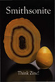
| Smithsonite slice and egg, 5.8 and 2.7 cm tall Masua Mine, Carbonia-lglesias, Sardinia, Italy Cal and Kerith...cm wide 400 Foot Level, Kelly Mine, Magdalena District Socorro County, New Mexico Steve Neely collection...978-0-9790998-6-1 Publisher Lithographie, LLC Denver, Colorado, USA Design and Layout Gloria Staebler Gunther Neumeier...Lithographie, LLC P.O. Box 11613 • Denver, C O 80211 • USA Phone 1.303.495.5521 • Fax 1.303.482.1238 www.lithographie...Giorgio Violino, Wolfgang Wendel Debra Wilson and Wendell Wilson Lithographie, LLC • Denver p. 92 p |
 | | Report (volume) |
| . 234 " y { " ,-t .. .~,:",. I " , COLORADO "or.! _ +, (~ STATE OF .~ :'(' COL~ADO /... BULLETIN 40 RADIOACTIVE MINERAL OCCURRENCES OF COLORADO AND BlaLlllGRAPHY by James L. Nelson-Moore,...Energy COLORADO GEOLOGICAL SURVEY DEPARTMENT OF NATURAL RESUURCES STATE OF COLORADO DENVER, COLORADO 1978...ete 11 st r ng of rad i aaet 1ve occurrences 1n Colorado, with a comprehensive blbi iography and bibliographic...on the Colorado Plateau sparked several periods of exploratIon that ultimately led to a mining "boom ll |
 | | Report (issue) |
| Quadrangle, Colorado GEOLOGICAL SURVEY PROFESSIONAL Prepared in cooperation with the Colorado State Geological...Geological Survey Board and the Colorado Metal Mining Fund PAPER 289 Geology and Ore Deposits of...of the Garfield Quadrangle, Colorado By McCLELLAND G. DINGS and CHARLES S. ROBINSON GEOLOGICAL SURVEY...in cooperation with the Colorado State Geological Survey Board and the Colorado Metal Mitting Fund. A...~:;e~:t;_~~-e~~:-~~~~~ ~~~:~~~t~~ ==== ====== Mount Princeton quartz monzonite_ _ __ _____ _ Monzonitic |
 | | Book |
| 22092 573-308-3500 703-648-6045 or phone 800-USA-MAPS Map 3. Arkansas’ Ouachita Mountains 7.5 Minute...Location 1 Montgomery County quartz deposits................. Other Montgomery County quartz mines.......... 2 Garland County quartz deposits......................... Miller Mountain Quartz Mine................... Ron Coleman Quartz Mine................................... Saline County quartz deposits...........Sandstone Quarry, Pulaski County....... 4 Granite Mountain, Pulaski County..................... 5 Dug |
 | | Report (issue) |
| deposit. Table 4, part B, gives an alphabetic list of mine and properties followed by the deposit name. CHARACTERISTICS...the ore. Sulfides likely to be present include pyrite, galena, sphalerite, and arsenopyrite (Berger,...deposits used in Table 1 may represent a major mine, district name, or local town name or other prominent...in gold-quartz mines in the Meguma Group, that pyrite is the most abundant sulfide in mines California... Pyrrhotite appears to be been reported in just a single mine in the East Belt of the Sierra Nevada foothills |
 | | Book |
| MINES AND MINERALS OF THE GREAT AMERICAN RIFT (COLORADO-NEW MEXICO) Sine —_—< ¢ te om At _SHT 40...MINES AND MINERALS OF THE GREAT AMERICAN RIFT (COLORADO-NEW MEXICO) Richard Walker Holmes and Marrianna...Mines and minerals of the Great American Rift (Colorado-New Mexico). Bibliography: p. Includes index...index. 1. Mines and mineral resources—Colorado. 2. Mines and mineral resources—New Mexico. I. Kennedy, Marrianna...enter must be obtained to prevent trespass. Old mine workings are dangerous and entering underground |
 | | Journal (issue) |
| V With an Introduction and Epilog by Wendell Wilson A Supplement to the Mineralogical Record, May-...number 3 Publisher & Editor-in-Chief: Wendell E. Wilson Associate Publisher & Circulation Director: Thomas...on Amazonite 7.5 cm, from the Smoky Hawk claim, Colorado. Collected by the Dorris family; Tom Spann photo...Scovil photo. Vanadinite, 2.4 cm, from the Apache mine, Arizona. Collected by Evan Jones; Jeff Scovil photo...Miglioli photo. Fluorite, 7.4 cm, from the La Barre mine, France. Collected by Aubin Cosson; Niels Brouwer |
 | | Report (volume) |
| Minerals of Colorado: A 100- Year Record By EDWIN B. ECKEL GEOLOGICAL SURVEY BULLETIN 1 1 14 A...knowledge____________________________________ Future of Colorado mineralogy______________________________________...mineral localities and metallic mineral deposits of Colorado ________________________________ In pocket III...mineral localities and metallic mineral deposits of Colorado, has not been included in this reprint. Many of...especially Fischer and others, 1946). MINERALS OF COLORADO: A 100-YEAR RECORD By EDWIN B. EcKEL ABSTRACT |
 | | Book |
| Unraveling The Legends & The History Of The Lost Mine, Lost City, And The Lost Mission By Robert Edward......... 39 From La Ventaña, You Can See The Lost Mine ............................................................................. 79 How The Spanish Mining Story Unfolds ........................................... 81 The Earliest Sources Of The Spanish Mine Legends ............................................................... 111 1702: Rich Mines Near San Xavier ......................................... |
 | | Report (issue) |
| OF THE WHITEPINE AREA, TOMICHI MINING DISTRICT, GUNNISON COUNTY, COLORADO by Charles S. Robinson This...of the ore depoait* ..............*...... 143 Mine* and prospect* ......................... 147 Akron...W. and A. mine* ......... 191 Morning Star ........................... 194 North Star .............ILLUSTBATIONS Figure 1. Plate Index map of Colorado showing location of White pine area Front piece...the White pine area 3. Sketch of the Spar Copper mine 1. Geologic map and sections of the White pine |


