 | | Report (volume) |
| Minerals of Colorado: A 100- Year Record By EDWIN B. ECKEL GEOLOGICAL SURVEY BULLETIN 1 1 14 A...knowledge____________________________________ Future of Colorado mineralogy______________________________________...mineral localities and metallic mineral deposits of Colorado ________________________________ In pocket III...mineral localities and metallic mineral deposits of Colorado, has not been included in this reprint. Many of...especially Fischer and others, 1946). MINERALS OF COLORADO: A 100-YEAR RECORD By EDWIN B. EcKEL ABSTRACT |
 | | Report (issue) |
| Quadrangle, Colorado GEOLOGICAL SURVEY PROFESSIONAL Prepared in cooperation with the Colorado State Geological...Geological Survey Board and the Colorado Metal Mining Fund PAPER 289 Geology and Ore Deposits of...of the Garfield Quadrangle, Colorado By McCLELLAND G. DINGS and CHARLES S. ROBINSON GEOLOGICAL SURVEY...in cooperation with the Colorado State Geological Survey Board and the Colorado Metal Mitting Fund. A..._ Fremont dolomite _________________________ _ Chaffee formation __________________________ _ Leadville |
 | | Journal (article/letter/editorial) |
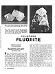
| 0.75 inch on edge, from the Henderson mine, Clear Creek County. Figure 2 (right). Green fluorite encrusted...Mountain Wilderness area near Columbine Lake, La Plata County; largest crystal measures 1.25 inches on edge;... FLUORITE BARBARA L. MUNTYAN Ouray County Museum Ouray, Colorado 81427 Mineral photographs by John R...locations in Mexico; in Elmwood, Smith County, Tennessee, and in Hardin County, Illinois, in the United States;...eastern Russia. It also occurs in many localities in Colorado, where it is found in colors ranging from pale |
 | | Book |
| MINES AND MINERALS OF THE GREAT AMERICAN RIFT (COLORADO-NEW MEXICO) Sine —_—< ¢ te om At _SHT 40...MINES AND MINERALS OF THE GREAT AMERICAN RIFT (COLORADO-NEW MEXICO) Richard Walker Holmes and Marrianna...Mines and minerals of the Great American Rift (Colorado-New Mexico). Bibliography: p. Includes index...index. 1. Mines and mineral resources—Colorado. 2. Mines and mineral resources—New Mexico. I. Kennedy, Marrianna...enter must be obtained to prevent trespass. Old mine workings are dangerous and entering underground |
 | | Report (issue) |
| IN CHAFFEE, FREMONT, AND JEFFERSON COUNTIES, COIO. By WALDEMAR LINDGREN. INTRODUCTION. Colorado is not...contributed to this output, but only two Lake (Leadville district) and San Juan yielded notable amounts. The Leadville...Juan County slightly exceeded 1,500,000 pounds. The copper ores, properly so called, of Colorado comprised...from San Juan County. It may be said that Colorado does not contain a single copper mine of prominence...prominence. Of the counties mentioned in the title Chaffee produced 349,466 pounds of cop'per from 6,249 tons |
 | | Journal (article/letter/editorial) |
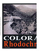
| August 2013 BARBARA L. MUNTYAN P.O. Box 495 Ouray, Colorado 8 I427 hodochrosite, a manganese carbonate with...Rhodochrosite has also been found in many localities in Colorado, particularly in the mines of the San luan Mountains...it i s one of the most recognized and coveted Colorado minerals. partiY DO e the presence of a mix...occurs in significant amounts in many mining districts of the Colorado mineral belt, a large, elongated,...extreme southwestem comer of Colorado. Most of the metal mining in Colorado has been within this belt since |
 | | Report (volume) |
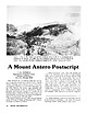
| Beryllium Deposits of the Mount Antero Region, Chaffee County, Colorado By JOHN W. ADAMS A CONTRIBUTION TO ECONOMIC...---The beryllium-bearing vein at the California mine.-___-_-----_-._-Location and history...________...119 ILLUSTKATIONS Page FIGURE 26. Index map of Colorado showing location of Mount Antero area________...---------27. Part of the Garfield quadrangle, Colorado and contiguous unmapped area_______--__--__--...Aerial photograph of area surrounding the California mine _ _ _ _ 29. South slope of Carbonate Mountain, looking |
 | | Report (issue) |
| Smith. Director Professional Paper 138 MINING IN COLORADO A HISTORY OF DISCOVERY, DEVELOPMENT AND PRODUCTJON...location, area, and organization of the mining counties of Colorado _________________________ _ Adams County_-..._____________________ _ Alamosa County __________________________ _ Arapahoe County _________________________...Archuleta County _________________________ _ Baca CountY-----------------------------Boulder CountY------...CountY----------------------~----Chaffee County _____________________·______ _ Clear Creek County _______________________ |
 | Church, S.E., Wilson, S.A., Vaughn, R.B., Fey, D.L. (1994) Geochemical and lead-isotopic studies of river and lake sediments, upper Arkansas River basin, Twin Lakes to Pueblo, Colorado. Open-File Report Vol. 1994 (94-412) US Geological Survey doi:10.3133/ofr94412 | Report (issue) |
| upper Arkansas River basin, Twin Lakes to Pueblo, Colorado by S.E. Church, S.A. Wilson, R.B. Vaughn, and................................................. Mining History and Production .................................................................... Chaffee County .................................................................................. Custer County ................................................................................... Fremont County .................................................... |
 | | Journal (issue) |
| Julius Weber Mamaroneck, New York COLORADO ISSUE #2 Articles Colorado locality index.............................. 323 by B. L. Muntyan What’s new in Colorado minerals? ...................................... Famous mineral localities: the Home Sweet Home mine ..................................................339 by M. I. Jacobson The San Juan Mountains of Colorado ..................................349 by J. A...10 cm tall, from the Yucca Hill claim, Park County, Colorado. Richard A. Kosnar specimen; photo by John |
 | | Report (volume) |
| mineralization in the Beaver-Tarryall area, Park County, Colo., a reconnaissance report, by Quentin D....Geology and ore deposits of the Shafter mining district, Presidio County, Tex., by Clyde P. Ross _______ ______...on concentration tests on manganese from Perry County, by H. S. Rankin______ 1 45 127 223 ILLUSTRATIONS...PLATE 1. Geologic map of Beaver-Tarryall area, Park County, Colo__ In pocket 2. Geologic sections of Beaver-Tarryall...Beaver-Tarryall area_______________ In pocket 5. Index map of mining properties in Beaver-Tarryall area___ 36 6. Reconnaissance |
 | | Report (issue) |
| Oxidized Zinc Deposits of the United States Part 3. Colorado By ALLEN V. HEYL GEOLOGICAL SURVEY BULLETIN...deposits and the resources of oxidized zin.c ores in Colorado UNITED STATES· GOVERNMENT PRINTING OFFICE, WASHINGTON...19180xidized zinc deposits of the United States. Part 3. Colorado. Washington, U.S. Govt. Print. Off., 1964. vi...Bibliography : p. 88-91. 1. Zinc ores-Colorado. 2. Zinc mines and mining-Colorado. I. Title. (Series) For sale...__ ___ __ __ __ __ __ _____ Kokomo (Ten ~ile) district _______ ._________________________ Breckenridge |
 | | Journal (article/letter/editorial) |
| of COLORADO ED RAINES Geology Museum Colorado School of Mines 1310 Maple Street Golden, Colorado 80401...noted Figure 1. Camp Bird mine, level 2, Sneffels district, Ouray County. Raines-Pettem collection,...photographer unknown. B etween 1868 and 1922, Colorado produced almost 260 million pounds of copper....from the Leadville district, with another 50 million pounds mined in San Juan County (Henderson 1926).... During the twentieth century, the Gilman district surpassed Leadville in total copper production with |
 | | Report (issue) |
| Deposits of the Poncha Springs NE Quadrangle, Chaffee County,Colorado By RALPH E. VAN ALSTINE With a section... 626 Prepared in cooperation with the Colorado State Mining Industrial Development Board UNITED STATES...Van Alstine and Doak C. Cox _________ _ Colorado-American mine ______________ -_Delay adit and Lloyd shaft...--_-----_Manganese Hill and Chimney Hill mines_Last Chance mine _________________ -_-_Other fluorspar deposits ________... Geologic map of the Colorado-American fluorspar mine, Browns Canyon district. Geologic map of underground |
 | | Journal (article/letter/editorial) |
| with its representation of mining tools clearly proclaim Montana’s mining origins. Montana’s production...published describing the occurrence, collecting, mining, and cutting of the two state gemstones. Figure...2. Granville Stuart established Montana’s first mining camp at Gold Creek in 1860. Geologic Provinces...MICHAEL J. GOBLA 19055 East Bethany Place Aurora, Colorado 80013 gobla@copper.net Unless otherwise noted...view showing the Indian Queen mine ca. 1905 at Farlin, Beaverhead County. 208 ROCKS & MINERALS Downloaded |
 | | Report (volume) |
| it helpful to refer to Survey Bulletin 507, "The mining districts of the western United States," and to...abundant, it may have been completely exhausted by mining or quarrying. Deposits of minerals of wide distribution...because they occur in sufficient quantity to warrant mining for their usual products but because they furnish...A. F. Rogers, Stanford University, Palo Alto. Colorado.........Prof. R. D. George, Boulder. Connecticut...See Bauxite and Hallpysite. Asbestos. Tallapoosa County, with corundum deposits near Dudleyville; not found |
 | | Report (issue) |
| Pass Districts, Saguache and Gunnison Counties, Colorado U.S. GEOLOGICAL SURVEY PRO FESS I 6N A L P A PE...Bldg., 2600 corridor, 18th and CSts.,NW. DENVER, Colorado-Federal Bldg., Rm. 169, 1961 Stout St. LOS ANGELES...ROLLA, Missouri-1400 Independence Rd. DENVER, Colorado-Map Distribution, Bldg. 810, Federal Center FAIRBANKS...Pass Districts, Saguache and Gunnison Counties, Colorado By JERRY C. OLSON U.S. GEOLOGICAL SURVEY PROFESSIONAL...Pass districts, Saguache and Gunnison Counties, Colorado. (U.S. Geological Survey professional paper ; |
 | | Book (volume) |
| ...........................................59 Colorado ...............................................................548 Table of Maps Page Alabama County Map ...................................................................................4 Alaska County and Stream Map ..................................Co. Mining Districts ............................................................22 Arizona County Map.........................23 Arizona – Cochise Co. Mining Districts .................................... |
 | | Report (issue) |
| SURV Department of Natural Resources Denver, Colorado/ 2009 NOa COVER CREDITS Design: Larry Scott...collection, Colorado Historical Society (see page 16) ISBN: 978-1-884216-23-7 Colorado Geological Survey...koom?/ 15 Denver, CO. 80203 (303) 866-2611 Colorado Geological Survey Information Series 33 GOLD...GOLD PANNING AND PLACERING 622.342 P238 IN COLORADO How AND WHERE =e Drawings and maps drafted by...Digital version recompiled by Larry Scott —— COLORADO DEPARTMENT OF NATURAL RESOURCES Harris D. Sherman |
 | | Report (volume) |
| ............................................. Colorado........................................................................................ 102 District of Columbia ....................................to refer to Geological Survey Bulletin 507, "The mining districts of the western United States," and to...abundant it may have been completely exhausted by mining or quarrying. Deposits of minerals that are widely...because they occur in sufficient quantity to warrant mining for their usual products, but because they furnish |
 | | Book |
| .3 COLORADO. of COLORADO. J. S. l GEORGETOWN, COLO. GEORGETOWN COURIER PRINT. 1887. 3 Bancroft...From a mineralogical point of view the wealth of Colorado exceeds that of In the metallic minerals almost...to in the following pages Proceedings of the Colorado Scientific Society. Proceedings of the Academy...the U. S. Geological Survey. J. GEORGETOWN, COLORADO, January, 1887. S. RANDALL. : MINERALS...gravel of streams and in veins. The veins of Gilpin County are especially noteworthy for the amount of gold |
 | | Journal (article/letter/editorial) |
| pegmatite prospecting on Mount Antero, Chaffee County, Colorado, gives a detailed account of fine min... 1. Quartz-beryl-pyrite veins. This type includes the veins at the California mine in Browns Creek (Landes...along the divide between Browns Creek and Baldwin Gulch. The fracture-filling veins cut the Mount Antero...TYPES OF BERYLLIUM DEPOSITS AND OCCUR RENCES IN COLORADO AND SOME EXAMPLES I . Deuteric-magmalic. Beryl-bearing...Lode) and Devils Hole, Fremont County; Crystal Mountain, Larimer County. B. Phenacite. Mt. Antero. C. |
 | | Report (issue) |
| GEOLOGY AND ORE DEPOSITS OF THE BONANZA MINING DISTRICT, COLORADO BY W. S. BURBANK WITH A SECTION ON HISTORY...HENDERSON Prepared in cooperation with the COLORADO METAL MINING FUND UNITED STATES GOVERNMENT PRINTING...Geography _ ______________ ___-__-__ Situation of the district _ _ _________________ Topographic features. ....Previous geologic and topographic work in the district. ____ ___________._-__-______--__. Field work...___________ Devonian sedimentary rocks- _____ ______ Chaffee formation__________________ Position and thickness |
 | | Report (issue) |
| description of the geology, mining history, and production of the major gold-mining districts in 21 States...relations ---------------------------History of gold mining and trends in production_ J\labama -----------...--------------Cleburne County ----------~----------------- Tallapoosa County --------------------------Alaska...------------------Cochise County -----------------------------Gila County --------------------------------Greenlee...ee County ----------------------------R[aricopa County ----------------------------R[ohave County -- |
 | | Report (issue) |
| Ore Deposits of the· Kokomo-Tenmile District, Colorado By M. H. BERGENDAHL and A. H. KOSCHMANN . I...PAPER 652 Prepared in cooperation with the Colorado Mining Industrial Development Board .. 1\ UNITED..._ Carbonate veins ___________________________ _ Pyrite-sphalerite-galena veins ________________ _ Ore...llypogene ore minerals__________________________ Pyrite __ -_-________________________________ Sphaler...ores-----------------------------Mine descriptions----------------------------------Wilfley-Kimberly mine __ --------________________ |


