| Locality type: | Mine |
| Classification |
|---|
|
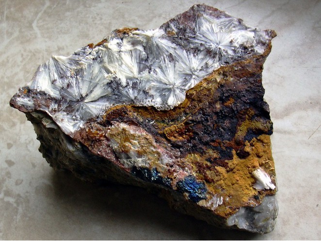
| Species: | Wavellite |
| Formula: | Al3(PO4)2(OH,F)3 · 5H2O |
| Confirmation |
|---|
|
| Validity: | Believed Valid |
| Data |
|---|
|
| Mineral Data: | Click here to view Wavellite data |
| Locality Data: | Click here to view Tannenberg Mine (Shaft 176), Schneckenstein, Tannenbergsthal, Muldenhammer, Vogtlandkreis, Saxony, Germany |
| Data Identifiers |
|---|
|
| Mindat Occurrence Record ID: | 381710 |
| Long-form Identifier: | 1:3:381710:0 |
| GUID (UUID V4): | e64b568d-cc75-4399-90e5-bbb0a91a81b6 |
| Nearest other occurrences of Wavellite |
|---|
|
|
| 0.7km (0.4 miles) | ⓘSchneckenstein cliff (Königskrone Topaz Mine), Schneckenstein, Tannenbergsthal, Muldenhammer, Vogtlandkreis, Saxony, Germany |
| 15.2km (9.5 miles) | ⓘFriedrich August adit, Riesenberg, Sosa, Eibenstock, Erzgebirgskreis, Saxony, Germany |
| 18.4km (11.4 miles) | ⓘAltmannsgrün, Tirpersdorf, Vogtlandkreis, Saxony, Germany |
| 18.7km (11.6 miles) | ⓘSchloditz, Tirpersdorf, Vogtlandkreis, Saxony, Germany |
| 34.4km (21.3 miles) | ⓘNeugattendorf, Gattendorf, Hof District, Upper Franconia, Bavaria, Germany |
| 40.6km (25.2 miles) | ⓘHuber stock (Huber shaft; Hub stock), Krásno, Sokolov District, Karlovy Vary Region, Czech Republic |
| 40.8km (25.3 miles) | ⓘGreisen deposit, Vysoký Kámen, Krásno, Sokolov District, Karlovy Vary Region, Czech Republic |
| 42.2km (26.2 miles) | ⓘGreifensteine, Ehrenfriedersdorf, Erzgebirgskreis, Saxony, Germany |
| 51.2km (31.8 miles) | ⓘReust Mine, Ronneburg, Greiz District, Thuringia, Germany |
| 51.7km (32.1 miles) | ⓘLichtenberg Absetzer dump, Kauern, Greiz District, Thuringia, Germany |
| References |
|---|
|
|


Tannenberg Mine, Schneckenstein, Tannenbergsthal, Muldenhammer, Vogtlandkreis, Saxony, Germany