 | | Report (issue) | | from the vicinity of the Hack Canyon mines, Mohave County, northern Arizona by Bradley S. Van Gosen 1...hole 0.7 miles northwest of the Hack II and III mines in northern Arizona. The core was donated to the U...unaltered, unmineralized rock within the Grand Canyon. The core hole is collared in the Harrisburg Gypsiferous...fine-grained sandstone and calcarenite with bluish-white gypsum and 289.5 ft of the Fossil Mountain Member, containing...dolomite, limestone, sandstone, siltstone, and gypsum of the Woods Ranch Member; 200 ft of light-gray |  | | Report (issue) | | the Red Butte area of Kaibab National Forest, Arizona By Karen J. Wenrich1 Open File Report 92-219 ...southwestern corner of the Colorado Plateau in northern Arizona. Some of these breccia pipes are host to high-grade...is located in the middle of this breccia pipe district and may include as many as several hundred breccia...these lie within the Tusayan Ranger District and include the Canyon, New Year, Black Box, Butte NE, Shale...Wenrich, 1988 for locations). One of these, the Canyon pipe (fig. 1), contains a high-grade uranium orebody |  | | Report (issue) | | Solution-Collapse Breccia-Pipe Province, Grand Canyon Region, Arizona by Karen J. Wenrich 1 & Hoyt B. Sutphin...12. 13. 1H. 15. 16. 17. Index map of northern Arizona and the Colorado Plateau..... Photograph of breccia.................. Aerial photograph of the Pigeon mine....................... Northeast-trending alignments..................... Paleogeography of northern Arizona in the Triassic......... Page 3 H 5 7 10 11 12...SOLUTION-COLLAPSE BRECCIA-PIPE PROVINCE, GRAND CANYON REGION, ARIZONA Karen J. Wenrich & Hoyt B. Sutphin U.S |  | | Report (issue) | | Breccia Pipes on the Coconino Plateau, Northwestern Arizona U.S. GEOLOGICAL SURVEY BULLETIN 1683-C I This...Breccia Pipes on the Coconino Plateau, Northwestern Arizona By BRADLEY S. VAN GOSEN and KAREN J. Computer...SURVEY BULLETIN 1683 BRECCIA PIPES IN NORTHERN ARIZONA WENRICH DEPARTMENT OF THE INTERIOR DONALD PAUL...northwestern Arizona. (U.S. Geological Survey bulletin ; 1683-C) Bibliography: p. 1. Breccia-Arizona-Coconino...no County. 2. Magnetic prospectingArizona-Coconino County. I. Wenrich, Karen J. II. Title. Ill. Title: |  | | Report (issue) | | between footwall and hanging wall seams, Carroll mine.______--_-_____________________________________...Cross section through Crooks Gap area, Fremont County, Wyo__ __________-______-___--_--__------------_...roll, Rex No. 1 mine- ______ 50. Fault in back of stoped-out ore roll, Rex No. 1 mine- ___---___-_---...of Eocene age in uplifted fault block at RanRex mine.- _____________________________________________...of part of the Ridenour mine showing uraniferous copper vein and outline of mine workings. ________ 54 |  | | Book | | Billingsley • Earle E. Spamer • Dove Menkes G R A N D CANYON f I (jw^B^-^ !-^,.t^jw! ;^iiy 'r --jiSs*, '''...PILLAR OF GOLD T h e Mines 8c Miners of the Grand Canyon by George H . Billingsley U.S. Geological Survey...Survey 2255 N . Gemini Drive Flagstaff, Arizona 86001 Earle E. Spamer Academy of Natural Sciences 1900 Benjamin... GRAND CANYON ASSOCIATION P.O. Box 399 Grand Canyon, AZ 86023 vvww.thecanyon.com/gca Grand Canyon Association...educational goals of Grand Canyon National Park. Cover: The Grandview Mine, in a photo taken by Arion |  | | Report (volume) | | Reconnaissance Study of Uranium Deposits in Arizona GEOLOGICAL SUR.VEY BULLETIN Prepared on behalf... Reconnaissance Study of Uranium Deposits in Arizona By H. C. GRANGER and R. B. RAUP CONTRIBUTIONS...deposits___-_-____--__-__-..--__-__---__-_-_---__--__Cochise County.______________________________________________...County_____________________________________________ Hosteen Nez Mining Company deposits..-._________________ Orphan claim...__________________________________________ Gila County..._______________________________________ Deposits |  | | Report (issue) | | BUREAU OF LAND MANAGEMENT WILDERNESS STUDY AREAS IN ARIZONA By J. A. Peterson, S. S. Page Nedell, and J. R...proposed Arizona National Forest Wilderness Act of 1984 (S. 2242) and the proposed Arizona Wilderness...of the northern Bradshaw Mountains, Yavapai County, Arizona: U.S. Geological Survey Bulletin 1336, 82 p...Ellis, C. E., 1984, Fossil Springs Roadless Area, Arizona, J.n_ Marsh, S. P., Kropschot, S. J., and Dickinson...Kanab Creek Roadless Area, Coconino and Mohave Counties, Arizona: U.S. Geological Survey Miscellaneous |  | | Book (edition) | | MINERALOGY OF ARIZONA,FOURTHEDITION V e a o_ of li rizo TI RAYMOND W. GRANT RONALD B. GIBBS...CALLAHAN THE UNIVERSITY OF ARIZONA PRESS TUCSON f -- The University of Arizona Press www.uapress.arizona...arizona.edu © 2022 by The Arizona Board of Regents All rights reserYed. Published 2022 ISBN-13: 978-0-8165-4358-8...McDonald Co\·er photo: \\ 7 ulfenite, Rowley Mine, Maricopa County, 4 cm high specimen, Evan and Melissa Jones...Grant, Raymond \X'.,author. Title: Mineralogy of Arizona/ Raymond W. Grant [and 4 others] ; maps and illustrations |  | | Book (edition) | | MINERALOGY OF ARIZONA • Wu!fenite. Red Cloud mine, Si/district, Trigo Mountains, La Paz County, Arizona...Tucson .. The University of Arizona Press Copyright © 1977, r982, 1995 Arizona Board of Regents All rights...Congress Cataloging-in-Publication Data Mineralogy of Arizona/ John W. Anthony ... [et al.]; Wendell E. Wilson...0-8165-1555-7 (pbk. : alk. paper) 1. Minerals-Arizona. I. Anthony, John W (John Williams), 1920-. QE375...HISTORY OF ARIZONA MINING AND MINERALOGY The Prehistoric Period 20 Arizona Under Spanish Rule Arizona as a |  | Wenrich, K.J., Van Gosen, B. S., Balcer, R.A., Scott, J.H., Mascarenas, J.F., Bedinger, G.M., Burmaster, Betsi (1985) A mineralized breccia pipe in Mohawk Canyon; lithologic and geophysical logs. Open-File Report Vol. 1985 (85-469) US Geological Survey doi:10.3133/ofr85469 | Report (issue) | | GEOLOGICAL SURVEY A mineralized breccia pipe in Mohawk Canyon Lithologic and Ge1physical logs Karen J. Wenrich...Reservation ••••••••••••••••••••••••••••••••••• Mohawk Canyon Pipe •••••••••••••••••••••••••••••••••••••••••••••••••••••••••...the Grand Canyon of Arizona................................ Index maps of northern Arizona •••••••••...Photo of Mohawk Canyon pipe •• ~ •••••••••••••••••••••••••••••••••• Photo of Mohawk Canyon ••••••••••••...map for Mohawk Canyon pipe ••••••••••••••••••••••••••••• Geologic Map of the Mohawk Canyon pipe •••••••••••••••••••••••••• |  | | Report (issue) | | National Tank Area, Hualapai Indian Reservation, Arizona This research was funded by the Bureau of Indian...terrain and vegetation. Hualapai Indian Reservation~ Arizona. Chapter B The Potential of Breccia Pipes in...National Tank Area, Hualapai Indian Reservation, Arizona By KAREN J. WENRICH, GEORGE H. BILLINGSLEY, and...SURVEY BULLETIN 1683-B BRECCIA PIPES IN NORTHERN ARIZONA DEPARTMENT OF THE INTERIOR MANUEL LUJAN, JR....Hualapai Indian .Reservation, Arizona. · (Breccia pipes in northern Arizona;ch. B) (U.S. Geological Survey | | | Book (edition) | | OF ARIZONA Wulfenite. Red Cloud mine, Silver district, Trigo Mountains, La Paz County, Arizona. Smithsonian...by Ed Over. Chip Clark photo. MINERALOGY OF ARIZONA THIRD EDITION W. Anthony Joh n Sidney A. Williams...of Arizona Press / Tucson The University of Arizona Press Copyright © 1977, 1982, 1995 Arizona Board...Congress Cataloging-in-Publication Data Mineralogy of Arizona / John W. Anthony . . [et al.] ;Wendell E. Wilson...0-8165-1555-7 (pbk. : alk. paper) 1. Minerals—Arizona. QE375-5-A6M56 I. Anthony, John W. (John Williams) |  | | Report (issue) | | northeastern Hualapai Indian Reservation and vicinity, Arizona Karen J. Wenrich 1 , George H. Billingsley 1 ,...Geological Survey, Denver, Colorado, and Flagstaff, Arizona ^University of Wyoming, Laramie, Wyoming CONTENTS...FIGURE 1. 2. 3. 4. Page Index map of northern Arizona showing the location of plateaus, Hualapai Indian...the northeastern Hualapai Indian Reservation, Arizona.......................4 Geographic map of the northeastern...northeastern Hualapai Indian Reservation, Arizona.......................................5 Idealized structural |  | | Report (issue) | | Residents of Arizona MINERALS OF ARIZONA by Frederic W. Galbraith and Daniel J. Brennan THE ARIZONA BUREAU...UNIVERSITY OF ARIZONA TUCSON FOREWORD As a service about mineral matters in Arizona, the Arizona Bureau of...University of Arizona, is pleased to reprint the long-standing booklet on MINERALS OF ARIZONA. This basic...Dr. Frederic W. Galbraith, as a bulletin of the Arizona Bureau of Mines. It has moved through several editions...released in its Fourth Edition as Bulletin 181, Arizona Bureau of Mines. The comprehensive coverage of |  | | Report (issue) | | A Mineralized Breccia Pipe in Mohawk Canyon, Arizona Lithologic and Geophysical Logs u.s. GEOLOGICAL... Chapter A A Mineralized Breccia Pipe in Mohawk Canyon, Arizona Lithologic and Geophysical Logs By KAREN J...SURVEY BULLETIN 1683 BRECCIA PIPES IN NORTHERN ARIZONA DEPARTMENT OF THE INTERIOR DONALD PAUL MODEL...Data A Mineralized breccia pipe in Mohawk Canyon, Arizona lithologic and geophysical logs. (U.S. Geological...(Geology) Arizona Mohawk Canyon. 2. Breccia Arizona Mohawk Canyon. 3. Ore-deposits Arizona Mohawk Canyon. 4 |  | | Report (issue) | | of the Jumpup Canyon and Big Springs Quadrangles, Mohave and Coconino Counties, Arizona. by George H...Survey, Flagstaff, Arizona 1 LIST OF FIGURES Figure 1. Location map of the Jumpup Canyon (A) and Big Springs...Springs (B) 15 minute quadrangles, Mohave and Coconino Counties, Arizona. Figure 2. Map showing geomorphic...of the Jumpup Canyon and Big Springs quadrangles, Mohave and Coconino Counties, Arizona. Figure 3. Stages...north-trending monocline-fault zone, Grand Canyon region, Arizona (Huntoon, 1989, p. 80). Figure 4. Schematic |  | | Report (issue) | | National Tank Area, Hualapai Indian Reservation, Arizona by 12 1 Karen J. Wenrich , George H. Billingsley.....................1 Breccia pipes of northern Arizona..........................................3 Pipes... 4b. 5. 6. 7a. 7b. 8. Index maps of northern Arizona showing the location of plateaus, Hualapai Reservation...units that host breccia pipes in the Grand Canyon region of Arizona......................4 Map of Hualapai...NATIONAL TANK AREA, HUALAPAI INDIAN RESERVATION, ARIZONA By KAREN J. WENRICH, GEORGE H. BILLINGSLEY, AND |  | | Book (edition) | | /BRA PY Muineralogy of Arizona Stope in oxide ore, Copper Queen mine, Bisbee. These old workings...Peter Kresam and Richard Graeme . Mineralogy of Arizona John W. Anthony, Sidney A. Williams, and Richard...Richard A. Bideaux AN THE UNIVERSITY OF ARIZONA PRESS TUCSON, ARIZONA About the Authors... JoHN W. ANTHONY...M.S. degrees in geology from the University of Arizona and his Ph.D. from Harvard University. Following...mineralogist with the Arizona Bureau of Mines, he joined the faculty of the University of Arizona, where he rose | | | Book (edition) | | 0.C D.?~•.!~'J..~5 ~!~.~J.RY Mineralogy of Arizona Stope in oxide ore, Copper Queen tnine, Bisbee...Richard A. Bideaux THE UNIVERSITY OF ARIZONA PRESS TUCSON, ARIZONA About the Authors . .. JOHN W. ANTHONY...M.S. degrees in geology from the University of Arizona and his Ph.D. from Harvard University. Following...mineralogist with the Arizona Bureau of Mines, he joined the faculty of the Uni~ersity of Arizona, where he rose...Gem and Mineral Society, and the University of Arizona. SIDNEY A. WILLIAMS has authored or co-authored |  | | Report (volume) | | most important were those in the Central City district, Colorado, from which about 300 tons of high-grade...Silver Cliff mine, Wyoming; the Jesse D No. 1 and No. 2 claims, Utah; and the Merry Widow mine, New Mexico...mines, Washington; the W. Wilson mine, Montana; the White King mine, Oregon; the deposits in the Pryor...deposits in the Dripping Spring quartzite, Gila County, Ariz. According to Nininger (1954, p. 43), as...Shinkolobwe, Belgian Congo, and from the Eldorado mine, Great Bear Lake, Canada. The Shinkolobwe deposit |  | | Report (issue) | | Evolution of a Grand Canyon Breccia Pipe: The Ridenour Copper-Vanadium-Uranium Mine, Hualapai Indian Reservation...Reservation, Coconino County, Arizona by 1 1 9 Earl R. Verbeek , Marilyn A. Grout , and Bradley S. Van.................................................. Mine location and access............................................... Fracture network near Ridenour mine...................................... Methods of...Ridenour mine............................................. General configuration of pipe and mine...... |  | | Report (issue) | | ____________________________________ _ History of mining and production ________________ _ General description...States. FIGURE 1. Map showing location of uranium-mining districts in West-Central United States-------------------------2...outcrop of the Coconino Sandstone in the Grand Canyon area, Arizona ___ --------- ______ --------- ________...and shapes of sandstone pipes in the Grand Canyon area, Arizona ___________ -------------· ·--------- ________...in 1874 at Mauch Chunk (now Jim Thorpe), Carbon County, Pa. ('Genth, 1875, p. 144B). In 1898 a deposit |  | Van Gosen, B. S., Wenrich, K.J., Sutphin, H.B., Scott, J.H., Balcer, R.A. (1989) Drilling of a U-mineralized breccia pipe near Blue Mountain, Hualapai Indian Reseveration, northern Arizona. Open-File Report Vol. 1989 (89-100) US Geological Survey doi:10.3133/ofr89100 | Report (issue) | | Mountain, Hualapai Indian Reservation, northern Arizona by Bradley S. Van Gosen1 , Karen J. Wenrich1 ,.................... 5 Breccia pipes of northern Arizona .......................................... 5 Breccia............ 15 Silicified pinnacles in northern Arizona breccia pipes .................... 15 USGS drilling... 8. 9. 10. 11. 12. 13. Index map of northern Arizona ................................... 3 Location...showing stratigraphic units transgressed in the Grand Canyon area ................... 7 Aerial photo of the |  | | Report (issue) | | Breccia PipeS in the Mohawk Canyon Area, Hualapai Indian Reservation, AriZona This research was funded...north at the central half of the Mohawk Canyon Area. Mohawk Canyon extends along the eastern edge of the...along the bottom of this part of the canyon. The Mohawk Canyon pipe is exposed in the Kaibab Limestone...Breccia Pipes in the Mohawk Canyon Area, Hualapai Indian Reservation, Arizona By KAREN J. WENRICH, GEORGE...SURVEY BULLETIN 1683 BRECCIA PIPES IN NORTHERN ARIZONA U.S. DEPARTMENT OF THE INTERIOR MANUEL LUJAN |
|
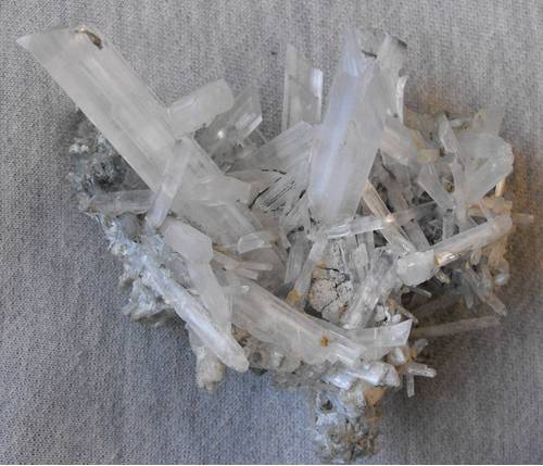


Hack Canyon Mine, Hack Canyon, Hack Canyon Mining District, Mohave County, Arizona, USA