| Locality type: | Mine |
| Classification |
|---|
|
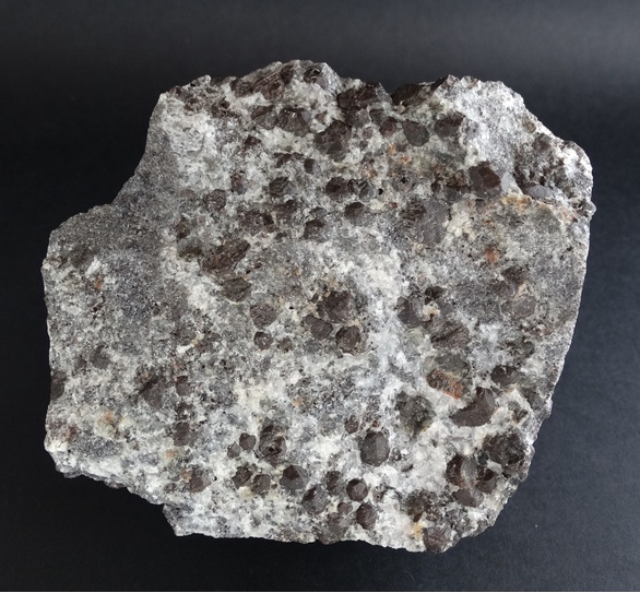
| Species: | Almandine |
| Formula: | Fe32+Al2(SiO4)3 |
| Confirmation |
|---|
|
| Validity: | Believed Valid |
| Data |
|---|
|
| Mineral Data: | Click here to view Almandine data |
| Locality Data: | Click here to view Batère mines, Corsavy, Céret, Pyrénées-Orientales, Occitanie, France |
| Data Identifiers |
|---|
|
| Mindat Occurrence Record ID: | 487794 |
| Long-form Identifier: | 1:3:487794:3 |
| GUID (UUID V4): | 2fb85d62-42f3-4841-95bf-52c0e2e6646c |
| Nearest other occurrences of Almandine |
|---|
|
|
| 3.0km (1.9 miles) | ⓘLes Manerots, La Bastide, Céret, Pyrénées-Orientales, Occitanie, France |
| 7.8km (4.9 miles) | ⓘMassif du Canigou, Vernet-les-Bains, Prades, Pyrénées-Orientales, Occitanie, France |
| 9.5km (5.9 miles) | ⓘCol des Voltes, Taurinya, Prades, Pyrénées-Orientales, Occitanie, France |
| 17.9km (11.1 miles) | ⓘPic de Fontfrède (Puig de Fontfreda), Céret, Céret, Pyrénées-Orientales, Occitanie, France |
| 19.5km (12.1 miles) | ⓘCostabona Mtn, Espinavell (Espinabell), Molló, Girona, Catalonia, Spain |
| 25.8km (16.0 miles) | ⓘCaladroy, Bélesta, Prades, Pyrénées-Orientales, Occitanie, France |
| 26.0km (16.2 miles) | ⓘMas d'en Freixa, Montesquieu-des-Albères, Céret, Pyrénées-Orientales, Occitanie, France |
| 26.9km (16.7 miles) | ⓘRavin de Camarere, Caramany, Prades, Pyrénées-Orientales, Occitanie, France |
| 28.9km (18.0 miles) | ⓘFeilluns (Felluns), Prades, Pyrénées-Orientales, Occitanie, France |
| 32.7km (20.3 miles) | ⓘPuig Neulós, La Jonquera, Girona, Catalonia, Spain |
| References |
|---|
|
|


Batère mines, Corsavy, Céret, Pyrénées-Orientales, Occitanie, France