 | | Report (issue) | | geology of the Hacks, Ridenour, Riverview and Chapel breccia pipes, northwestern Arizona BY William L. Chenoweth................................. Exploration and mining history................................. Summary............. Hacks Mine................................................ Ridenour Mine........................... Riverview Mine............................................ Chapel prospect.....................data , Hacks Mine.............................. 47 47 Geochemical data, Ridenour Mine............. |  | | Book | | Billingsley • Earle E. Spamer • Dove Menkes G R A N D CANYON f I (jw^B^-^ !-^,.t^jw! ;^iiy 'r --jiSs*, '''...PILLAR OF GOLD T h e Mines 8c Miners of the Grand Canyon by George H . Billingsley U.S. Geological Survey...Survey 2255 N . Gemini Drive Flagstaff, Arizona 86001 Earle E. Spamer Academy of Natural Sciences 1900 Benjamin... GRAND CANYON ASSOCIATION P.O. Box 399 Grand Canyon, AZ 86023 vvww.thecanyon.com/gca Grand Canyon Association...educational goals of Grand Canyon National Park. Cover: The Grandview Mine, in a photo taken by Arion |  | | Report (issue) | | Evolution of a Grand Canyon Breccia Pipe: The Ridenour Copper-Vanadium-Uranium Mine, Hualapai Indian Reservation...Reservation, Coconino County, Arizona by 1 1 9 Earl R. Verbeek , Marilyn A. Grout , and Bradley S. Van.................................................. Mine location and access................................................... Fracture network near Ridenour mine...................................... Methods.............................. Geology of the Ridenour mine............................................ |  | | Report (issue) | | northeastern Hualapai Indian Reservation and vicinity, Arizona Karen J. Wenrich 1 , George H. Billingsley 1 ,...Geological Survey, Denver, Colorado, and Flagstaff, Arizona ^University of Wyoming, Laramie, Wyoming CONTENTS...FIGURE 1. 2. 3. 4. Page Index map of northern Arizona showing the location of plateaus, Hualapai Indian...the northeastern Hualapai Indian Reservation, Arizona.......................4 Geographic map of the northeastern...northeastern Hualapai Indian Reservation, Arizona.......................................5 Idealized structural |  | Wenrich, K.J., Verbeek, E.R., Sutphin, H.B., Modreski, P.J., Van Gosen, B. S., Detra, D.E. (1990) Geology, geochemistry, and mineralogy of the Ridenour Mine breccia pipe, Arizona. Open-File Report Vol. 1990 (90-504) US Geological Survey doi:10.3133/ofr90504 | Report (issue) | | Geochemistry, and Mineralogy of the Ridenour Mine Breccia Pipe, Arizona by Karen J. Wenrich 1 , Earl R. Verbeek...structure of the Ridenour mine ................................. 5 Structural control of the Ridenour and similar...similar pipes ....................... 7 Mine workings ............................................................. 11 Metals strongly enriched at the Ridenour pipe ......................... Vanadium ................................... 32 Discussion of Ridenour pipe mineralization ......................... |  | | Book (edition) | | MINERALOGY OF ARIZONA,FOURTHEDITION V e a o_ of li rizo TI RAYMOND W. GRANT RONALD B. GIBBS...CALLAHAN THE UNIVERSITY OF ARIZONA PRESS TUCSON f -- The University of Arizona Press www.uapress.arizona...arizona.edu © 2022 by The Arizona Board of Regents All rights reserYed. Published 2022 ISBN-13: 978-0-8165-4358-8...McDonald Co\·er photo: \\ 7 ulfenite, Rowley Mine, Maricopa County, 4 cm high specimen, Evan and Melissa Jones...Grant, Raymond \X'.,author. Title: Mineralogy of Arizona/ Raymond W. Grant [and 4 others] ; maps and illustrations |  | | Report (issue) | | Suspected Breccia Pipes on the Coconino Plateau, Northwestern Arizona U.S. GEOLOGICAL SURVEY BULLETIN...Suspected Breccia Pipes on the Coconino Plateau, Northwestern Arizona By BRADLEY S. VAN GOSEN and KAREN...SURVEY BULLETIN 1683 BRECCIA PIPES IN NORTHERN ARIZONA WENRICH DEPARTMENT OF THE INTERIOR DONALD PAUL...suspected breccia pipes on the Coconino Plateau, northwestern Arizona. (U.S. Geological Survey bulletin...p. 1. Breccia-Arizona-Coconino County. 2. Magnetic prospectingArizona-Coconino County. I. Wenrich, Karen |  | | Report (issue) | | Solution-Collapse Breccia-Pipe Province, Grand Canyon Region, Arizona by Karen J. Wenrich 1 & Hoyt B. Sutphin...12. 13. 1H. 15. 16. 17. Index map of northern Arizona and the Colorado Plateau..... Photograph of breccia.................. Aerial photograph of the Pigeon mine....................... Northeast-trending alignments..................... Paleogeography of northern Arizona in the Triassic......... Page 3 H 5 7 10 11 12...SOLUTION-COLLAPSE BRECCIA-PIPE PROVINCE, GRAND CANYON REGION, ARIZONA Karen J. Wenrich & Hoyt B. Sutphin U.S |  | | Report (volume) | | Addition Wi Iderness Study Areas, San Bernardino County, California U.S. GEOLOGICAL SURVEY BULLETIN 1713-D...Addition Wilderness Study Areas, San Bernardino County, California By SHERMAN P. MARSH, GARY L. RAINES...DONALD B. HOOVER U.S. Geological Survey JAMES RIDENOUR, PHILLIP R. MOYLE, and SPENCEE L. WILLETT U.S...Wilderness Study Area (AZ-050-010), San Bernardino County, California. CONTENTS Summary Dl Abstract Dl...identified resources D7 Methods of evaluation D7 Mining history D8 Appraisal of sites examined in the Whipple |  | Van Gosen, B. S., Wenrich, K.J., Sutphin, H.B., Scott, J.H., Balcer, R.A. (1989) Drilling of a U-mineralized breccia pipe near Blue Mountain, Hualapai Indian Reseveration, northern Arizona. Open-File Report Vol. 1989 (89-100) US Geological Survey doi:10.3133/ofr89100 | Report (issue) | | Mountain, Hualapai Indian Reservation, northern Arizona by Bradley S. Van Gosen1 , Karen J. Wenrich1 ,.................... 5 Breccia pipes of northern Arizona .......................................... 5 Breccia............ 15 Silicified pinnacles in northern Arizona breccia pipes .................... 15 USGS drilling... 8. 9. 10. 11. 12. 13. Index map of northern Arizona ................................... 3 Location...showing stratigraphic units transgressed in the Grand Canyon area ................... 7 Aerial photo of the |  | | Journal (article/letter/editorial) | | 1722-1735 Mineralization of BrecciaPipesin Northern Arizona KARENJ. WENRICH U.S. GeologicalSurvey,P.O. Box25048...iationof the THE Colorado Plateau of northern Arizona is host to rockwithinthe steepwallsof the pipe...-1452.50 1722 BRECCIAPIPEMINERALIZATION,N. ARIZONA 1723 lB) of the BatCavepipe,lie directlyon faultswhich...westernmarginof the ColoradoPlateau)across Riverview mine have over 2 percent UaO8 (K. J. the HualapaiIndian...content, alCanyonnorthto theUtahborder;theflurryof mining thoughsilvercouldbe extractedasa by-product;the |  | | Report (issue) | | the Red Butte area of Kaibab National Forest, Arizona By Karen J. Wenrich1 Open File Report 92-219 ...southwestern corner of the Colorado Plateau in northern Arizona. Some of these breccia pipes are host to high-grade...is located in the middle of this breccia pipe district and may include as many as several hundred breccia...these lie within the Tusayan Ranger District and include the Canyon, New Year, Black Box, Butte NE, Shale...Wenrich, 1988 for locations). One of these, the Canyon pipe (fig. 1), contains a high-grade uranium orebody |  | | Report (issue) | | Breccia PipeS in the Mohawk Canyon Area, Hualapai Indian Reservation, AriZona This research was funded...north at the central half of the Mohawk Canyon Area. Mohawk Canyon extends along the eastern edge of the...along the bottom of this part of the canyon. The Mohawk Canyon pipe is exposed in the Kaibab Limestone...Breccia Pipes in the Mohawk Canyon Area, Hualapai Indian Reservation, Arizona By KAREN J. WENRICH, GEORGE...SURVEY BULLETIN 1683 BRECCIA PIPES IN NORTHERN ARIZONA U.S. DEPARTMENT OF THE INTERIOR MANUEL LUJAN |  | | Report (issue) | | Breccia Pipes in the Mohawk Canyon Area, Hualapai Indian Reservation, Arizona by 1 o Karen J. Wenrich ,.................... 1 Breccia pipes of northern Arizona........................................... 2 Breccia...Reservation............................ 5 The Mohawk Canyon area............................................. 10 Mapping of collapse features in the Mohawk Canyon area................ 10 Collapse features/breccia...features/breccia pipes exposed in the Hermit Shale, Coconino Sandstone, and Toroweap Formation............ |  | | Report (issue) | | southwestern Hualapai Indian Reservation and vicinity, Arizona by George H. Billingsley1 , Karen J. Wenrich1...Government. ''U.S. Geological Survey, Flagstaff, Arizona and Denver, Colorado ^University of Wyoming, Laramie...vicinity, Arizona. pipe location map of the northwestern Hualapai Indian and vicinity, Arizona. Page Figure...the southwestern Hualapai Indian Reservation, Arizona.......................................... 4 Figure...southwestern part of the Hualapai Indian Reservation, Arizona............................................... |  | | Journal (issue) | | we met Meredith York at the Funderburk mercury prospect in the Cowhide Cove recreational area on Lake...SteveBlyskalphoto. (Continues on page~-z) Grand Canyon Uranium: The Orphan Mine Dr. Vivien Gornitz vgornitz@giss.nasa...copper mines in the southern part of the state, Arizona nonetheless has produced significant quantities...from collapsed breccia pipe deposits in the Grand Canyon region. Hundreds, possibly thousands, of these...crop out in the canyons and plateaus of northern Arizona. However, only a small percent are mineralized |  | | Report (volume) | | most important were those in the Central City district, Colorado, from which about 300 tons of high-grade...Silver Cliff mine, Wyoming; the Jesse D No. 1 and No. 2 claims, Utah; and the Merry Widow mine, New Mexico...mines, Washington; the W. Wilson mine, Montana; the White King mine, Oregon; the deposits in the Pryor...deposits in the Dripping Spring quartzite, Gila County, Ariz. According to Nininger (1954, p. 43), as...Shinkolobwe, Belgian Congo, and from the Eldorado mine, Great Bear Lake, Canada. The Shinkolobwe deposit |  | | Report (issue) | | northwestern Hualapai Indian Reservation and vicinity, Arizona Wenrich, K.J. 1 , Billingsley, G.H. 2 , and Huntoon...Denver, Colorado U.S. Geological Survey, Flagstaff, Arizona ^University of Wyoming, Laramie, Wyoming CONTENTS...pipes............................. 1 ^ Surprise Canyon Formation association with breccia pipes.........and vicinity, Arizona location map of the northwestern Hualapai and vicinity, Arizona Figure 1. Geographic...northwestern part of the Hualapai Indian Reservation Arizona.......................................2 Figure |  | | Report (issue) | | published information, field investigations, and mining company data. 2 ABBREVIATIONS USED IN THIS REPORT...resources Mining districts Gibbonsville Mining District Indian Creek Mining District Mineral Hill Mining District...Mackinaw Mining District Blackbird Mining District Wilson Creek Mining District Yellowjacket Mining District...Range Mining District Eureka Mining District Carmen Creek Mining District Eldorado Mining District Pratt...Creek Mining District McDevitt Mining District Junction Mining District Texas Mining District Spring |  | | Report (issue) | | Planet Peak Wilderness Study Areas,, La Paz County, Arizona U.S. GEOLOGICAL SURVEY BULLETIN 1 704-B AVAILABILITY...Planet Peak Wilderness Study Areas, La Paz County, Arizona By ROBERT G. EPPINGER, JOCELYN A. PETERSON... STEPHEN J. REYNOLDS, and MICHAEL J.GRUBENSKY Arizona Geological Survey TERRY J. KREIDLER and DAVID C...RESOURCES OF WILDERNESS STUDY AREAS: HAVASU REGION, ARIZONA U.S. DEPARTMENT OF THE INTERIOR MANUEL LUJAN...Planet Peak wilderness study areas, La Paz County, Arizona / by Robert G. Eppinger ... [et al.]. p. cm |  | | Report (volume) | | of a solution-collapse breccia pipe in the Grand Canyon region, showing the general distribution of uranium...and detachment-fault-related mineral deposits in Arizona, southeastern California, and southernmost Nevada...The data for each deposit include placer type, mining method(s), production history, bedrock source,...the three deposit types. Tabulated data for each district include tonnage, grades, basement rocks, and references...gneiss-hosted gold model (No. 37c) is based on the Tumco mine group and American Girl-Padre y Madre mines in the |  | | Report (volume) | | 1988), and on December 7, 1989, at the Northwest Mining Association 95th Annual Convention and Trade Show...the Mineral Hill and Warm Springs mining districts, Blaine County, Idaho: Idaho Bureau of Mines and Geology...Deposits in the Lake Creek Mineralized Area, Blaine County, South-Central Idaho By Bradford R. Burton and...Mineral Deposits in the Washington Basin Area, Custer County, South-Central Idaho By J. Brian Mahoney H. Mineral...Mineral Deposits at Leadbelt, Lava Creek Mining District, South-Central Idaho By Sandra J. Soulliere |  | | Report (issue) | | presented to the Annual Convention of the Northwest Mining Association, Spokane, Washington, December 7, 1989...I°x2° quadrangle and ore deposits of the Atlanta district, Idaho .................... Snee, L.W. , and Kunk...Link, P.K., Lake Creek mineralized area, Blaine County, Idaho ...................... Doyle, M.A., Geology..., Geology and ore deposits of Garfield Canyon, Blaine County, Idaho ...................... Mahoney, J...mineral deposits of the Washington Basin area, Custer County, Idaho ................ Mahoney, J.B., and Horn |  | | Report (volume) | | San Bernardino Counties, California By JAMES RIDENOUR, STEVEN W. SCHMAUCH, and NICHOLAS T. ZILKA, U...Cucamonga Wilderness and Additions, San Bernardino County, California By NICHOLAS T. ZILKA and STEVEN W....San Bernardino Counties, California, by James Ridenour, Steven W. Schmauch, and Nicholas T. Zilka _____...Cucamonga Wilderness and additions, San Bernardino County, California, by Nicholas T. Zilka and Steven W...the two study areas are separated by San Antonio Canyon. The mineral-resource potential of these two areas |  | | Report (issue) | | A Mineralized Breccia Pipe in Mohawk Canyon, Arizona Lithologic and Geophysical Logs u.s. GEOLOGICAL... Chapter A A Mineralized Breccia Pipe in Mohawk Canyon, Arizona Lithologic and Geophysical Logs By KAREN J...SURVEY BULLETIN 1683 BRECCIA PIPES IN NORTHERN ARIZONA DEPARTMENT OF THE INTERIOR DONALD PAUL MODEL...Data A Mineralized breccia pipe in Mohawk Canyon, Arizona lithologic and geophysical logs. (U.S. Geological...(Geology) Arizona Mohawk Canyon. 2. Breccia Arizona Mohawk Canyon. 3. Ore-deposits Arizona Mohawk Canyon. 4 |
|
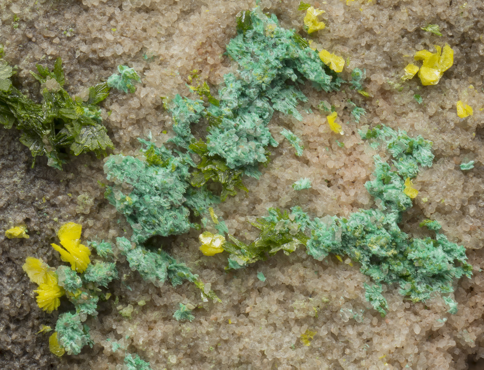


Ridenour Mine, Prospect Canyon Mining District, Coconino County, Arizona, USA