 | | Report (issue) |
| conditions should be noted: PETERBOROUGH TRlP 2 - Point of lnterest 3 is now inside Figure 6, p. 23 Petroglyphs...northern shore of Stony Lake. - Highway 134 is shown, but is not labelled. - BANCROFT TRlP 1 - This mine...most of the Photo 27, p. 59 buildings have been removed. It is also private property. BANCROFT TRlP 2...2 Figure 10, p. 64 BANCROFT TRlP 3 Figure 11, p. 68 Photo 39, p. 74 - Highway 127 is now Highway...Highway 62. - The road between Points of lnterest 4 and 5 is too poor. Go via Hybla. - Highway 500 is now Highway |
 | | Book |
| 1 Bancroft & District CHAMBER OF COMMERCE P.O. B o x 5 3 9 , B a n c r o f t , O N K 0 L 1C0 Tel: (613)...commerce.bancroft.on.ca Be sure to visit... The Bancroft Mineral Museum Located in the "Old Station",...Lookout Get an overview of Bancroft and the scenic York River Valley from the top of this granite batholith...rushes over the rocks of the chute. The Gut This steep, narrow canyon is part of the Crowe River Valley...fee-for-collecting site is one of the finest locations in the region, with excellent samples of titanite, apatite |
 | | Journal (article/letter/editorial) |
| PETROLOGY OF THE NEPHELINE AND CORUNDUM ROCKS OF SOUTHEASTERN ONTARIO Lours Moyn, Bancroft,Ontario. CowrrNrs...Description of the nepheline and corundum rocks. Occurrence. Structures. Composition .. Genesis of the nepheline...nepheline and corundum rocks. Statement of hypothesis. . Alteration of the Grenville rocks by magmatic emanations...i o no f n e p h e l i n e . . . . . . Formation of corundum Later alterations. .. . Age relations. ...southeastern Ontario. Field evidence appears to indicate that most of the nepheline and corundum rocks of this |
 | | Report (Issue volume) |
| II ONTARIO and QUEBEC Ann P. Sabina MISCELLANEOUS REPORT 8 Issued by THE GEOLOGICAL SURVEY OF CANADA...CANADA Department of Mines and Technical Surveys, Ottawa $1.65 © Crown Copyrights reserved Available by...Queen's Printer, Ottawa, the Geological Survey of Canada, 601 Booth St., Ottawa, and at the following Canadian...deposit copy of this publication is a~so available for reference in public libraries across Canada. Price $...S.C. Queen's Printer and Controller of Stationery Ottawa, Canada 1964 Page • INTRODUCTION 2 • A note |
 | | Journal (issue) |
| Bariand Sorbonne Paris, France Bill Birch Museum of Victoria Melbourne, Australia Pete J. Dunn Washington...University of Michigan Ann Arbor, Ml George W. Robinson Natl. Museums of Canada Ottawa, Ontario Abraham......................187 by P. B. Moore The origin of faden quartz ............................................191 by R. P. Richards Amethyst occurrences of the eastern United S ta tes........................B. Cook Edgarbaileyite, the first known silicate of mercury, from California and Texas ............. |
 | | Report (issue) |
| ONTARIO DEPARTMENT OF MINES Hon. G. C. Wardrope, Minister D. P. Douglass, Deputy Minister J. E. Thomson...Geological Branch Pegmatite Mineral Resources of Ontario By D. F. HEWITT Industrial Mineral Report 21...Production in Ontario (Table 1). . . . . .. . . . ... Number of Pegmatite Deposits opened in Ontario (Table...(Table 2) ... . . Classification of Pegmatites. . . ... . . . . . . . . . ... . . . ... . . . . .. . . . ..... . . . .. . . . . ... . Origin and Mode of Emplacement of Pegmatites.. .. . . . . .. .. . . .... . |
 | | Report (issue) |
| GEOLOGICAL SURVEY OF CANADA DEPARTMENT OF ENERGY, MINES AND RESOURCES A CATALOGUE OF CANADIAN MINERALS...SURVEY OF CANADA CANADA PAPER 69-45 A CATALOGUE OF CANADIAN MINERALS R. J. Traill DEPARTMENT OF ENERGY...n's Printer, Ottawa from the Geological Survey of Canada 601 Booth St., Ottawa and Canadian Government...without notic e Queen ' s Printer for Canada Ottawa 1970 A CATALOGUE OF CANADIAN MINERALS INTRODUCTION ...Sterry Hunt in Geology of Canada, 1863 , presented the first descriptive list of Canadian minerals . Hunt |
 | | Journal (article/letter/editorial) |
| advertisements will be inserted. Forms close the 10th of even months. RULES FOR E X C H A N G I N G M I N...SPECIMENS. PLEASE FOLLOW T H E M . 1. State type of specimens wanted and not wanted. 2. Return privileges...in regards to species, location, condition, size of xls and matrix, and associated minerals. 4. After...or unusual minerals for common minerals at a ratio of one for one. 6 . L a s t but not least wrap a label...Cashmere, Washington. I H A V E M A N Y DUPLICATES of several rare minerals b o t h i n large and micro |
 | | Report (edition) |
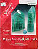
| DEPARTMENT OF CONSERVATION 1998 Copyright © 1998 by the Maine Geological Survey, Department of Conservation...reserved. Printed in the United States of America. No part of this publication may be reproduced, stored...or otherwise, without the prior written permission of the publisher. Front cov5r photograph: Elbaite crystals...5 cm tall; gem weighs 2 carats. From the Havey Quarry, Poland, MaifJ. e. Photo copyright 1995 by Wendell...on quartz crystals, 24 x JO mm;Jrom the Bennett Quarry, Buckfield, Maine. Mined in 1996 by Holden !Jrothers |
 | | Report (volume) |
| DEPARTMENT OF THE INTERIOR UNITED STATES GEOLOGICAL SURVEY CHARLES D. WALCOTT, DIRECTOR OF NORTH AMERICAN... PRINTING 1 903 OFFICE O'Q.S. Pago. Letter of transrnittal....................................................:............................. List of publications examined..............................£3373 5 7 9 13 124 125 133 LETTER OF TRANSMITTAL. DEPARTMENT OF THE INTERIOR, UNITED STATES GEOLOGICAL...to transmit herewith the manuscript) of a bibliography and index of North American geology, paleontology |
 | | Journal (article/letter/editorial) |
| References for, and updating of, L. J. Spencer's first and second supplementary lists of British minerals H. G...G. MACPHERSON Department of Geology, Royal Scottish Museum, Edinburgh EH1 1JF L. J. SPENCER (1898, 1931)...compiled lists of British minerals supplementary to those listed in Greg and Lettsom's Manual of the Mineralogy...Mineralogy of Great Britain and Ireland (1858). These lists were published in the Reports of the British Association...Association for the Advancement of Science, and reprinted in Mineralogical Magazine, 31, 806-10 (1958) |
 | | Report (volume) |
| DEPARTMENT OF THE INTERIOR UNITED STATES GEOLOGICAL SURVEY GEORGE OTIS SMITH, DIRECTOR BULLETIN 495...495 BIBLIOGRAPHY OF NORTH AMERICAN GEOLOGY FOR 1910 WITH SUBJECT INDEX BY JOHN M.. NICKLES WASHINGTON................................. Classified scheme of subject headings...................................6 11 113 115 161 161 162 164 165 BIBLIOGRAPHY OF NORTH AMERICAN GEOLOGY FOR 1910, WITH SUBJECT INDEX...JOHN M. NICKLES. INTRODUCTION. The bibliography of North American geology, including paleontology, petrology |
 | | Report (issue) |
| GEOLOGICAL SURVEV OF CANADA COMMISSION GEOLOGIQUE DU CANADA CATALOGUE OF CANADIAN MINERALS Revised 1980...CATALOGUE OF CANADIAN MINERALS Revised 1980 R.J. TRAILL @ Minister of Supply and Services Canada 1983...1983 Available i n Canada through authorized bookstore agents and other bookstores or by mail from Canadian...and Services Canada Hull, QuCbec, Canada K I A OS9 and from Geological Survey of Canada 601 Booth Street...Street Ottawa, Canada K 1A OE8 A deposit copy of this publication is also available for reference in public |
 | | Report (volume) |
| DEPARTMENT OF THE INTERIOR UNITED STATES GEOLOGICAL SURVEY GEORGE OTIS SMITH, DIRECTOR BULLETIN 617...617 BIBLIOGRAPHY OF ' ' NORTH AMERICAN GEOLOGY FOR 1914 WITH SUBJECT INDEX BY JOHN M. NICKLES WASHINGTON................................. Classified scheme of subject headings...................................... 99 142 142 143 144 145 2 , BIBLIOGRAPHY OF NORTH AMERICAN GEOLOGY FOR 1914, WITH SUBJECT INDEX...JOHN M. NICKLES. INTRODUCTION. The bibliography of North American geology, including paleontology, petrology |
 | | Report (volume) |
| DEPARTMENT OF THE INTERIOR UNITED STATES GEOLOGICAL SURVEY CHARLES D. WALCOTT, DIRECTOR OF NORTH AMERICAN.............................................. List of publications examined... 1......................... Page. 5 6 11 383 393 BIBLIOGRAPHY AND INDEX OF NORTH AMERICAN GEOLOGY, PALEONTOLOGY, PETROLOGY,...WEEKS. INTRODUCTION. This bulletin is a combination of the bibliographies published each year from 1901...203, 221, 240, and 271. With these the bibliography of the literature for the year 1905 has been combined |
 | | Book (volume) |
| it the largest of the Atlantic seaboard states. It is situated at the southern end of the Appalachian...chain of mountains. These ranges extend into the northeast corner where Brasstown Bald, a part of the Nantahala...Piedmont Plain (about 30% of the state), and the Atlantic Coastal Plain. Thus rocks of every geological age...other forests of stately pines on the Piedmont. Beneath the highland forests lie some of the oldest crystalline...crystalline rocks into softer and less resistant formations of the Coastal Plain. This Fall Line extends southwesterly |
 | | Report (volume) |
| DEPARTMENT OF THE INTERIOR UNITED STATES GEOLOGICAL SURVEY GEORGE OTIS SMITH, DIRECTOR BULLETIN 419...419 ANALYSES OF ROCKS AND MINERALS FEOM THE LABORATORY OF THE UNITED STATES GEOLOGICAL SURVEY \ 1880...average composition of rocks. ..'.....< .................................. Analyses of igneous and crystalline......................... 1. Rocks from Aroostook County..... ^..................'........... 2. Miscellaneous..................................... 15 1. Rocks of Mount Ascutney.................................. |
 | | Book (volume) |
| 0 n101ercai o of Maine j f·~ ....__ :,,. . - .._"' ..;. .. ~ L-- -~ \. • .J_..::.; I Volume...Geological Survey DEPARTMENT OF CONSERVATION Robert G. Marvinney, State Geologist of Maine Volume 2: Mining...DEPARTMENT OF CONSERVATION 2000 Copyright ©2000 by the Maine Geological Survey, Department of Conservation...reserved. Printed in the United States of America. No part of this publication may be reproduced, stored...or otherwise, without the prior written permission of the publisher. Cover photograph: Thomas Lamb (left) |
 | | Report (volume) |
| DEPARTMENT OF THE INTERIOR BULLETIN OF THE UNITED STATES GEOLOGICAL SURVEY No. 168 WASHINGTON GOyEKBMEMT...CHARLES D. WALCOTT, DIRECTOR ANALYSES OF ROOKS FROM THE LABORATORY OF THE UNITED GEOLOGICAL SURVEY 188O-1899......................... 1. Eocks from Aroostook County I............................. 19 19 2. Litchfieldite.......................................... 1. Eocks of Mount Ascutney ........................................................................... 1. Eocks of the Connecticut Valley.......................... |
 | | Report (issue) |
| DESCRIPTIVE MINERALOGY OF PENNSYLVANIA 104 Na 2Al 2 Si3 Oi .2H 2 O; SiO 2 47.4, A1 2 O 3 26.8, Na...Na 2 O 16.3, Lenni, Delaware County. Crystals. Eyerman, 1911, 11. Composition: Analysis: Fe 2 O3 CaO...LOCALITIES: Berks County: Birdsboro, and Gickerville; Delaware County: Leiperville, Lenni (druses of colorless... Felton's farm (Chester), and Ward's quarry; Montgomery County: Sumneytown, and Perkiomenville ; Philadelphia:...Philadelphia: Fairmount Park, Frankford, and Rit- enhouse quarry. SCOLECITE CaAl 2 Si3 Oi .3H 2 O MONOCLINIC |
 | | Report (issue) |
| UNITED STATES DEPARTMENT OF THE INTERIOR ALKALIC ROCKS OF IRON HILL GUNNISON COUNTY, COLORADO GEOLOGICAL...PROFESSIONAL PAPER 197-A UNITED STATES DEPARTMENT OF THE INTERIOR Harold L. Ickes, Secretary GEOLOGICAL...Professional Paper 197-A ALKALIC ROCKS OF IRON HILL GUNNISON COUNTY, COLORADO BY ESPER S. LARSEN Shorter...WASHINGTON : 1942 For sale by the Superintendent of Documents, Washington, D. C. ......... Price 40 cents...acknowledgments.________________ Geology of the surrounding area__________________ Age of the Iron Hill stock_____________________ |
 | | Book (volume) |
| Prairie State, Illinois exhibits a length of 378 miles and a width of 210 miles, with its 56,000 sq. mi. sloping...more than 275 rivers, the state is bounded along ¾ of its circumference by navigable waters, primarily...along the northern borders, rising only to a altitude of 900 to 1,000 feet above sea level. Though well endowed...the Lead-Zinc mining dists. of northwestern Illinois, the glacial drift of the Late Pleistocene Wisconsin...Wisconsin glaciation, the bluffs and detritus of the Ohio and Mississippi rivers, and in the southern Fluorspar |
 | | Report (volume) |
| No. 240 Series G, Miscellaneous, 28 DEPARTMENT OF THE INTERIOR UNITED STATES GEOLOGICAL SURVEY CHARLES...CHARLES D. VVALCOTT, DIRECTOR BIBIIOGRAP.HY AND INDEX OF NORTH AMERICAN GEOLOGY, PALEONTOLOGY, PETROLOGY...PRINTING 1904 OFFICE CONTENTS Page. Letter of transmittal................................................................,.................. List of publications examined ................................ 5 7 9 13 139 141 149 LETTER OF TRANSMITTAL DEPARTMENT OF THE INTERIOR, UNITED STATES GEOLOGICAL |
 | | Report (volume) |
| UNITED STATES DEPARTMENT OF THE INTERIOR Harold L. Ickes, Secretary GEOLOGICAL SURVEY W. C. Mendenhall... Bulletin 843 A BRIEF REVIEW OF THE GEOLOGY OF THE SAN JUAN REGION OF SOUTHWESTERN COLORADO BY WHITMAN...WASHINGTON : 1935 For sale by the Superintendent of Documents, Washington, D.C. - -- -- Price $1.00...________________________ ---__--i---_-_ Purpose and scope of the report _ _____-____-.__----------------Literature..... ____ _ ___ ____ _____ _____________ _A sketch of the geologic history ___ ________.____--__-__--______ |


