| Locality type: | Mine |
| Classification |
|---|
|
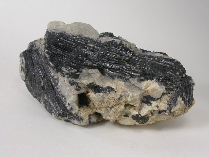
| Species: | Schorl |
| Formula: | NaFe32+Al6(Si6O18)(BO3)3(OH)3(OH) |
| Confirmation |
|---|
|
| Validity: | Confirmed |
| Confirmation Methods: | Dealer/Collection Label |
| Data |
|---|
|
| Mineral Data: | Click here to view Schorl data |
| Locality Data: | Click here to view Knack Mine (Steeperton Mine), Dartmoor Forest, West Devon, Devon, England, UK |
| Data Identifiers |
|---|
|
| Mindat Occurrence Record ID: | 1100979 |
| Long-form Identifier: | 1:3:1100979:7 |
| GUID (UUID V4): | 07edbb77-00b6-4a28-9c7b-b26b2526dbd6 |
| Nearest other occurrences of Schorl |
|---|
|
|
| 10.5km (6.5 miles) | ⓘBirch Tor & Vitifer Mine, Warren House, North Bovey, Teignbridge, Devon, England, UK |
| 17.9km (11.1 miles) | ⓘLeusdon Common, Widecombe-in-the-Moor, Teignbridge, Devon, England, UK |
| 19.3km (12.0 miles) | ⓘHedgemoor Farm, Bridford, Teignbridge, Devon, England, UK |
| 19.3km (12.0 miles) | ⓘBagtor Mine, Ilsington, Teignbridge, Devon, England, UK |
| 19.7km (12.2 miles) | ⓘRingleshutes Mine, Holne, South Hams, Devon, England, UK |
| 20.9km (13.0 miles) | ⓘWoolley Farm, Bovey Tracey, Teignbridge, Devon, England, UK |
| 21.3km (13.2 miles) | ⓘT Girt Tin Stream, Dartmoor Forest, West Devon, Devon, England, UK |
| 26.4km (16.4 miles) | ⓘLee Moor China Clay Pit, Shaugh Prior, South Hams, Devon, England, UK |
| 26.4km (16.4 miles) | ⓘHingston Down Quarry, Gunnislake, Calstock, Cornwall, England, UK |
| 37.1km (23.1 miles) | ⓘHawkswood Mine (Hawk's Wood Mine), North Hill, Cornwall, England, UK |
| References |
|---|
|
|


Knack Mine, Dartmoor Forest, West Devon, Devon, England, UK