| Locality type: | Quarry |
| Classification |
|---|
|
| Species: | Anatase |
| Formula: | TiO2 |
| Confirmation |
|---|
|
| Validity: | Confirmed |
| Confirmation Methods: | Visually Identified |
| Data |
|---|
|
| Mineral Data: | Click here to view Anatase data |
| Locality Data: | Click here to view Bílý Kámen quarry, Bílý Kámen, Jihlava District, Vysočina Region, Czech Republic |
| Photo Gallery | View Gallery (5 photos) |
| Data Identifiers |
|---|
|
| Mindat Occurrence Record ID: | 1106042 |
| Long-form Identifier: | 1:3:1106042:4 |
| GUID (UUID V4): | 284606ad-7b41-4b50-938d-f467595a9d2b |
| Nearest other occurrences of Anatase |
|---|
|
|
| 45.1km (28.0 miles) | ⓘPřibyslavice, Vlkaneč, Kutná Hora District, Central Bohemian Region, Czech Republic |
| 51.0km (31.7 miles) | ⓘRožná deposit, Rožná, Žďár nad Sázavou District, Vysočina Region, Czech Republic |
| 56.4km (35.0 miles) | ⓘBrunn, Dobersberg, Waidhofen an der Thaya District, Lower Austria, Austria |
| 59.8km (37.1 miles) | ⓘHomolka Hill, Stráž nad Nežárkou, Jindřichův Hradec District, South Bohemian Region, Czech Republic |
| 67.1km (41.7 miles) | ⓘWolfsbach, Drosendorf-Zissersdorf, Horn District, Lower Austria, Austria |
| 72.6km (45.1 miles) | ⓘPoschacher Quarry, Artolz, Pfaffenschlag bei Waidhofen, Waidhofen an der Thaya District, Lower Austria, Austria |
| 76.2km (47.3 miles) | ⓘWidy quarry, Gebharts, Schrems, Gmünd District, Lower Austria, Austria |
| 78.3km (48.7 miles) | ⓘEtzelsreith, Pernegg, Horn District, Lower Austria, Austria |
| 83.7km (52.0 miles) | ⓘGranite quarry, Leodagger, Pulkau, Hollabrunn District, Lower Austria, Austria |
| 89.3km (55.5 miles) | ⓘEichberg, Unterlembach, Großdietmanns, Gmünd District, Lower Austria, Austria |
| References |
|---|
|
|


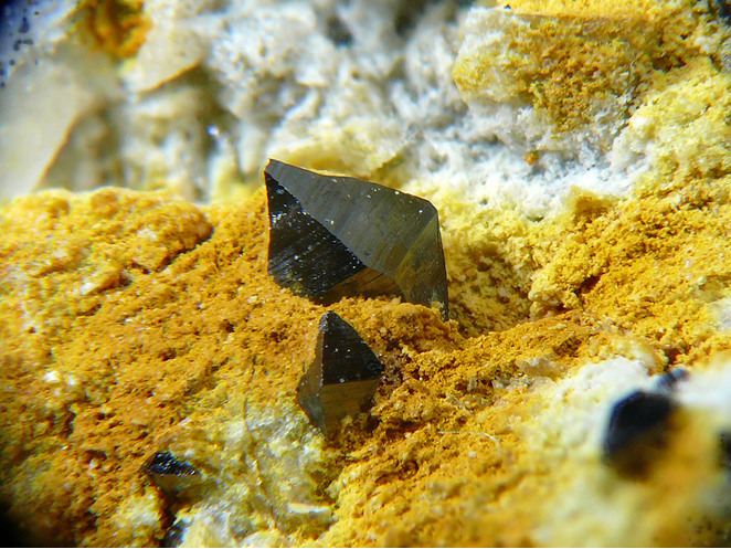


Bílý Kámen quarry, Bílý Kámen, Jihlava District, Vysočina Region, Czech Republic