 | | Report (issue) | | GOLD DEPOSITS NEAR QUARTZSITE, ARIZONA. By EDWARD L. JONES, Jr. INTRODUCTION. This report is based...extending eastward from the reservation to the Plomosa Mountains. The geology and ore deposits within the reservation...Bernardino, kindly furnished the early history of the La Paz district, and Mr. Edward Beggs, of Quartzsite,... gave much useful information regarding the La Paz placers. In 1909 Howland Bancroft x made a geologic...geologic reconnaissance of northern Yuma County .and much of the country around Quartzsite and farther west |  | | Report (issue) | | Cact s Plain Wild rness Study Areas, La Paz County, Arizona ARIZONA AVAILABILITY OF BOOKS AND MAPS OF...East Ca~tus Plain Wilderness Study Areas, La Paz· County, Arizona By RICHARD M. TOSDAL, ROBERT G. EPPINGER...RESOURCES OF WILDERNESS STUDY AREAS: HAVASU REGION, ARIZONA U.S. DEPARTMENT OF THE INTERIOR MANUEL LUJAN...East Cactus Plain Wilderness Study Areas, La Paz County, Arizona/ by Richard Tosdal...[et al.]. p. cm.-(Mineral...resources of wilderness study areas-Havasu region, Arizona : ch. D) (U.S. Geological Survey bulletin ; 1704-D) |  | Tosdal, R.M., Eppinger, R.G., Erdman, J.A., Hanna, W.F., Pitkin, J.A., Blank, H.R., O'Leary, R. M., Watterson, J.R. (1990) Mineral resources of the Cactus Plain and East Cactus Plain Wilderness Study Areas, La Paz County, Arizona. Open-File Report Vol. 1990 (90-510) US Geological Survey doi:10.3133/ofr90510 | Report (issue) | | EAST CACTUS PLAIN WILDERNESS STUDY AREAS, LA PAZ COUNTY, ARIZONA By Richard M. Tosdal1, Robert G. Eppinger2...Plain (AZ050-017) Wilderness Study Areas, La Paz County, Arizona. CONTENTS Summary 5 Abstract 5 Character...East Cactus Plain Wilderness Study Areas,, La Paz County, Arizona. 6 Map showing mineral resource potential...East Cactus Plain Wilderness Study Areas, La Paz County, Arizona. 8 Geochemically anomalous areas in and...and East Cactus Plain Wilderness Study Areas, Arizona. 24 Bouguer gravity anomaly map of the Cactus Plain |  | | Report (volume) | | Resources of the NeW,Water Mountains Wlldernes.\ Study LaP~ c~~ ARIZONA / AVAILABILITY OF BOOKS AND...Resources of the New Water Mountains Wilderness Study Area, La Paz County, Arizona By DAVID R. SHERROD, DAVID...WILDERNESS STUDY AREAS: SOUTHWESTERN AND SOUTH-CENTRAL ARIZONA DEPARTMENT OF THE INTERIOR MANUEL LUJAN, JR....resources of the New Water Mountains Wilderness Study Area, La Paz County, Arizona. (U.S. Geological Survey...mineral resources-Arizona-New Water Mountains Wilderness (Ariz.) 2. New Water Mountains Wilderness (Ariz |  | | Report (issue) | | Waste Characterization of the Sonoran Region, Arizona U.S. GEOLOGICAL SURVEY PROFESSIONAL PAPER 1370-D...Radioactive WasteCharacterization of the Sonoran Region, Arizona Edited by M.S. BEDINGER, K.A. SARGENT, and WILLIAM...1370-D Prepared in cooperation with the States of Arizona, California, Idaho, Nevada, New Mexico, Texas,...waste characterization of the Sonoran region, Arizona. (Geological Survey professional paper ; 1370-D)...1370-D) "Prepared in cooperation with the States of Arizona, California, Idaho, Nevada, New Mexico, Texas, |  | | Report (volume) | | RECONNAISSANCE OP THE ORE DEPOSITS IN NORTHERN YUMA COUNTY, ARIZONA ROWLAND BANCROFT WASHINGTON GOVERNMENT PRINTING............................................... 36 Gold deposits..........................................amphibolite, shale, and limestone.....; . 39 Thin films of gold deposited in joint planes in shale................................................... 72 On the Arizona side.. .-^............. r ...................................... 77 Deposits in the Dome Rock Mountains...........................:..... 78 Location |  | | Report (issue) | | WASTE CHARACTERIZATION OF THE SONORAN REGION, ARIZONA Edited by M.S. Bedinger, K.A. Sargent, and William...Alternates ARIZONA Member: Larry D. Fellows State Geologist and Assistant Director Arizona Bureau of Geology...Alternate: H. Wesley Peirce Principal Geologist Arizona Bureau of Geology and Mineral Technology Tucson...thick unsaturated zones in the Sonoran region, Arizona. 2.--Map showing hydrogeologic units and relative...water at the water table in the Sonoran region, Arizona. 3.--Map showing ground-water traveltimes, flow |  | Bagby, W.C., Haxel, G.B., Smith, D.B., Koch, R.D., Grubensky, M.J., Sherrod, D.R., Pickthorn, L.G. (1987) Mineral resource assessment of the Kofa National Wildlife Refuge, Arizona. Open-File Report Vol. 1987 (87-609) US Geological Survey doi:10.3133/ofr87609 | Report (issue) | | Assessment of the Kofa National Wildlife Refuge, Arizona William C. Bagby 1 , Gordon B. Haxel 2 , David...Map unit Jg Orocopia Schist Map unit Mzo McCoy Mountains Formation Map unit KJm Granite and granodiorite...Gneiss- or schist-hosted, detachment fault related(?) gold systems High temperature hot-spring systems Sed...Sedimentary-rock-hosted, disseminated precious-metal systems Gold and galena placer-depositing processes Rhyolite-Sn...(Cont'd) Discussion King of Arizona-North Star anomaly (1) Southern Plomosa anomaly (2) Sheep Tank anomaly |  | | Report (issue) | | OFFICE 1922 GEOLOGY OF THE .LOWER GILA REGION, ARIZONA. By CLYDE INTRODUCTION. In 1917 and the early...and routes of travel in a part of southwestern Arizona. The results of this work are to be published in...central part of Yuma County and the western part of Maricopa County, Ariz. In Maricopa County it indndes an...rivers and extending westward to the county boundary. In Yuma County the area is bounded on the north by...' of Gila River and extends entirely across the county to the western boundary, Colorado River. The commercial |  | | Report (issue) | | ARIZONA GEOLOGICAL SOCIETY 1979 Spring Field Trip March 31-April 1, 1979 ROAD LOGS Tucson to Yuma Wellton...Buckeye Note: Road logs will be published in Arizona Geological Society Digest 12. We urge you to contribute...AGS officer. THIS PAGE INTENTIONALLY BLANK Arizona Geological Society 1979 Spring Field Trip . STOPS...this draft copy. Dan Lynch TUCSON MOUNTAINS AND CATALINA MOUNTAINS TO MP 240 Pusch Ridge and the fore-range...fore-range of the Catalina Mountains lie to the north of this section of freeway. Details of structure are |  | | Report (volume) | | I I ' ,I I Iacer Gold ·Deposits 'o f Ariioi1a ' I ( t ' > '' G E 0 L. 0 G I C A L SUR V ....I ' f I ', .. I' I I Placer Gold Deposits of Arizona By MAUREEN G. JOHNSON GEOLOGICAL SURVEY...-----Introduction History of placer mining in Arizona ----------~-------'----------------Purpose and...- -------- - --- ----------------------Cochise County ____ __ ___ l. Dos Cabezas and Tevis1ton districts...district) --------------------3. Bisbee-Warren district (Gold Gulch placer) -----------------------4. Huachuca |  | | Report (issue) | | CASSITERITE IN SAN DIEGO COUNTY, CALIFORNIA. By WALDEMAR T. SCHALLER. A small handful of cassiterite...crystals was found in the northern part of San Diego County, Cal. (fig. 22), in the spring of 1915, and the...showing position of cassiterite locality in San Diego County, Cal. The rectangle indicates the gem tourmaline...tin ore in place previously known in San Diego County. These are as follows: F. J. H. Merrill 1 has stated...of Laguna Mountain, in the southern part of the county. Additional reported occurrences are in Pine Valley; |  | | Report (issue) | | PLAIN AREA, YUNA COUNTY, ARIZONA D. G. Motzger Prepared in cooperation with the Arizona State Land Department...of climato logical data, 1909-^0, Salome, Yuma County, Ariz, ..........................................climate logical data, 1918-U-O, Quartzite, Tuma County, Ariz ...........................................'-rells in northern part of Ranegras Plain area, Tuma County, Ariz. .................................. Logs...KSD of northern part of Ranegras Plain area, Yuma County, Ariz. 2. A, Looking northwest dovm the Rsnegras |  | | Book (edition) | | MINERALOGY OF ARIZONA,FOURTHEDITION V e a o_ of li rizo TI RAYMOND W. GRANT RONALD B. GIBBS...CALLAHAN THE UNIVERSITY OF ARIZONA PRESS TUCSON f -- The University of Arizona Press www.uapress.arizona...arizona.edu © 2022 by The Arizona Board of Regents All rights reserYed. Published 2022 ISBN-13: 978-0-8165-4358-8...Co\·er photo: \\ 7 ulfenite, Rowley Mine, Maricopa County, 4 cm high specimen, Evan and Melissa Jones Collection...Grant, Raymond \X'.,author. Title: Mineralogy of Arizona/ Raymond W. Grant [and 4 others] ; maps and illustrations |  | | Journal (article/letter/editorial) | | Jones, jun., briefly discusses the gold deposits near Quartzite, Arizona, close to the Colorado River Indian...Survey. Reservation. Placer mining started at La Paz as early as 1862, but was almost entirely abandoned...later. The placer areas in Dome Eock Mountains and Plomosa Mountains are composed of intrusive igneous rocks...heart of the Pilot Mountains, about 8 miles south-east of Mina, Esmeralda County. They came to light...deposits are situated 6 miles east of Beatty, Nye County, in the Fluorine mining district, partly on Bare |  | | Report (chapter) | | R A E. J O H N 3 1Department of Earth Sciences, La Trobe University, Melbourne, Vic. 3083, Australia...Geology, University of Florida, Gainesville, FL 32611, USA (e-mail." dfoster@geology, ufl.edu) 3Department of...Geophysics, University of Wyoming, Laramie, W Y 82071, USA Abstract: The Colorado River extensional corridor...corridor, southeastern California and western Arizona (Figs 1 and 2). We review detailed thermochronological...Fig. 1. Map showing mountain ranges in western Arizona and southeastern California. The shaded area shows |  | | Report (issue) | | DEPOSITS OF ARIZONA AND THE SOUTHWEST Arizona Geological Society and the University of Arizona 1986 Symposium...Mineralization. Harguahala-Granite WashBuckskin Mountains. West Central Arizona March 21-23, 1986 Leaders: J. Spencer...Coordinator: J. Welty (AzBGMT) ARIZONA GEOLOGICAL SOCIETY TUCSON, ARIZONA Cover preparation by Beverly...Volume XVI ARIZONA GEOLOGICAL SOCIETY P.O. BOX 40952, UNIVERSITY STATION TUCSON, ARIZONA 85719 To: ...Field Trip Participants Welcome to Arizona and the 1986 Arizona Geological Society Symposium "Frontiers |  | | Book | | helped. Photos on Page 1, (Winnowing Gold) & Page 2, (Drywashing Gold) Courtesy of California Division of...Geology OTHER BOOKS BY THE AUTHOR WHERE TO FIND GOLD IN SOUTHERN CALIFORNIA Copyright 1975 by James...Introduction .7 Where To Find Gold 1. Rosamond-Mohave Area.9 2. El Paso Mountains Area 3. Randsburg Area 4...7. Chocolate Mountains-Tumco-Potholes Area.69 8. Arizona Area .79 9. Other Desert Gold Bearing Areas...Areas .87 How To Find Gold 10. Some Tips on Desert Prospecting 11. How to Pan .95 . 105 12. How to Stake |  | | Journal (issue) | | WILLIAM MORROW AND COMPANY Volume RIVERSIDE COUNTY FAIR Number -magazine of the Outdoor SouthwestCHARLES...fRJINfGHTLYUNBERIHE DESERT STARS--6:45 COVER The delicate yellow-gold blossoms of Opuntia littoralis—the Coast Prickly...Ralph D. Cornell of Los Angeles. LOST MINE La Posa Gold Harold O. Weight Carlsbad's Little-Known World...LAKE POWELL, behind GLEN CANYON DAM near PAGE, Arizona. • Come join us in our 23rd year. • Identify above...1001st boating guest was SUSAN DOLESE of Ganado, Arizona —who won the fare refund. • Come join us Into A |  | | Book (edition) | | MINERALOGY OF ARIZONA • Wu!fenite. Red Cloud mine, Si/Mountains, La Paz County, Arizona...Tucson .. The University of Arizona Press Copyright © 1977, r982, 1995 Arizona Board of Regents All rights...Congress Cataloging-in-Publication Data Mineralogy of Arizona/ John W. Anthony ... [et al.]; Wendell E. Wilson...0-8165-1555-7 (pbk. : alk. paper) 1. Minerals-Arizona. I. Anthony, John W (John Williams), 1920-. QE375...HISTORY OF ARIZONA MINING AND MINERALOGY The Prehistoric Period 20 Arizona Under Spanish Rule Arizona as a |  | | Journal (issue) | | HEART OF ARIZONA 12 F. A. Barnes VOLCANOES IN THE DESERT 16 Bruce Vinson PANNING FOR GOLD IN ARIZONA...for Readers TRAVEL GUIDE TO ARIZONA s.. Sunset Travel Guide to Arizona, one learns quickly to really...mines, cemeteries, schools, views of California mountains, valleys and sky, forests and wildflowers all... MARKET BASKET PHOTO CO. P. O. Box 370, Yuma, Arizona 85364 or P. O. Box 2830, San Diego, Calif. 92112...slick paper, 319 pages. $6.95. HOW AND HERE TO PAN GOLD by Wayne Winters. Convenient paperback handbook |  | | Report (issue) | | /*VT oi Vidal California ancl Arizona Q,)Ef.atO6tCAX SURVEY e&tec n Godp&raM&n -w%1k me &$. fifmkiar...History of the Vidal-Parker Region, California and Arizona By W. J. CARR U.S. GEOLOGICAL SURVEY PROFESSIONAL...history of the Vidal-Parker region. California and Arizona. (U.S. Geological Survey professional paper ; 1430)...1. Geology California Vidal Region. 2. Geology Arizona Parker Region. 3. Geology, Structural. I. U.S........ Rocks at the east foot of the Riverside Mountains Rocks of probable late Paleozoic age ........ |  | Keith, S.B., Schnabel, Lorraine, DeWitt, Ed, Gest, D.E., Wilt, Jan (1983) Map, description and bibliography of the mineralized areas of the Basin and Range Province in Arizona. Open-File Report Vol. 1983 (84-86) US Geological Survey doi:10.3133/ofr8486 | Report (issue) | | Mineralized Areas of the Basin and Range Province in Arizona By Stanley B. Keith 1 Lorraine Schnabel 2 , Ed...editorial standards and stratigraphic nomenclature. Arizona Bureau of Geology and Mineral Technology; present...Tunder Dr., Phoenix, Arizona 85044 2U.S. Geological Survey, Denver, Colorado 80225 Arizona Bureau of Geology...Avenue, Tucson, Arizona 85719 ^J.C. Wilt and Co., 3035 So. Shiela Ave., Tucson, Arizona 85746 Contents...Mineralized Areas of the Basin and Range Province in Arizona..............................................in | | | Book (edition) | | OF ARIZONA Wulfenite. Red Cloud mine, Silver district, Trigo Mountains, La Paz County, Arizona. Smithsonian...by Ed Over. Chip Clark photo. MINERALOGY OF ARIZONA THIRD EDITION W. Anthony Joh n Sidney A. Williams...of Arizona Press / Tucson The University of Arizona Press Copyright © 1977, 1982, 1995 Arizona Board...Congress Cataloging-in-Publication Data Mineralogy of Arizona / John W. Anthony . . [et al.] ;Wendell E. Wilson...0-8165-1555-7 (pbk. : alk. paper) 1. Minerals—Arizona. QE375-5-A6M56 I. Anthony, John W. (John Williams) |  | | Report (issue) | | ARIZONA GEOLOGICAL SOCIETY 1985 SPRING FIELD TRIP GEOLOGY OF THE VULTURE & CONGRESS MINES MARICOPA &...& YAVAPAI COUNTIES, ARIZONA THIS PAGE INTENTIONALLY BLANK Figure 1 Vulture and Congress Mine field-trip...field-trip stops. BACKGROUND MATERIAL Il Arizona Geological Society qlgest, Volume XII, 1980 Geologic...West-Central Arizona by Stephen J. Reynolds 1 A bstract The geolo gy of west-central Arizona is complex...North America . Geolo gic st udies of west-central Arizona (Fi gs . 1 and 2) have lar gely been of a reconnaissance |
|
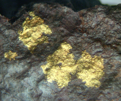


Dutchman Mine, Bouse, Plomosa Mining District, Plomosa Mountains, La Paz County, Arizona, USA