| Locality type: | Quarry |
| Classification |
|---|
|
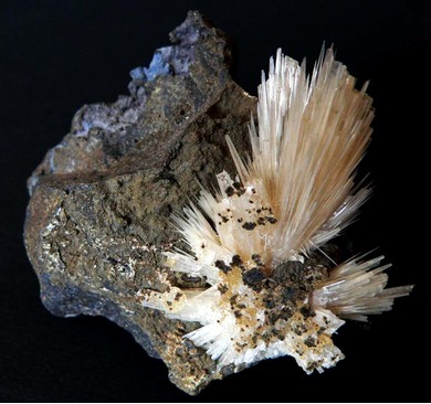
| Species: | Aragonite |
| Formula: | CaCO3 |
| Confirmation |
|---|
|
| Validity: | Believed Valid |
| Associated Minerals Based on Photo Data: |
|---|
|
| Calcite | ⓘ2 photos of Aragonite associated with Calcite at this locality. |
| Data |
|---|
|
| Mineral Data: | Click here to view Aragonite data |
| Locality Data: | Click here to view Curebourse quarry, Saint-Clément, Aurillac, Cantal, Auvergne-Rhône-Alpes, France |
| Photo Gallery | View Gallery (5 photos) |
| Data Identifiers |
|---|
|
| Mindat Occurrence Record ID: | 271169 |
| Long-form Identifier: | 1:3:271169:0 |
| GUID (UUID V4): | 6dd458a9-5788-4b65-8b76-1e0d2dc4063b |
| Nearest other occurrences of Aragonite |
|---|
|
|
| 11.4km (7.1 miles) | ⓘLe Dat Soubeyrol, Carlat, Aurillac, Cantal, Auvergne-Rhône-Alpes, France |
| 16.6km (10.3 miles) | ⓘSarrans dam, Sainte-Geneviève-sur-Argence, Argences en Aubrac, Rodez, Aveyron, Occitanie, France |
| 22.8km (14.2 miles) | ⓘN122 road cut, La Grange de Ganilh, Laveissière, Saint-Flour, Cantal, Auvergne-Rhône-Alpes, France |
| 38.8km (24.1 miles) | ⓘFaverolles quarry, Val-d'Arcomie, Saint-Flour, Cantal, Auvergne-Rhône-Alpes, France |
| 48.1km (29.9 miles) | ⓘLe Kaymar, Pruines, Rodez, Aveyron, Occitanie, France |
| 50.7km (31.5 miles) | ⓘPuech de Vermus, Espalion, Rodez, Aveyron, Occitanie, France |
| 61.5km (38.2 miles) | ⓘBasalt quarry, Chastreix, Issoire, Puy-de-Dôme, Auvergne-Rhône-Alpes, France |
| 75.0km (46.6 miles) | ⓘMineral spring, Saint-Nectaire, Issoire, Puy-de-Dôme, Auvergne-Rhône-Alpes, France |
| 77.3km (48.0 miles) | ⓘLapanouse-de-Sévérac slag locality, Sévérac-d'Aveyron, Rodez, Aveyron, Occitanie, France |
| 78.5km (48.8 miles) | ⓘRoca-Neyra, Perrier, Issoire, Puy-de-Dôme, Auvergne-Rhône-Alpes, France |
| References |
|---|
|
|


Curebourse quarry, Saint-Clément, Aurillac, Cantal, Auvergne-Rhône-Alpes, France