 | | Journal (article/letter/editorial) | | ans THORNTON L. NEATHERY GeologicalSurveyof Alabama,P.O. Box O, UniversityStation,Tuscaloosa, Alabama35486...BREVARD ROCKS GROUP MAD INOIAN GROUP FAULT HATCHET CREEK GROUP WEDOWEE GROUPHEARD GROUP -i--•----I-...1963; LaMont and Hastings, 1964; Magee, 1968; Alabama-Georgia state line; and (3) the Wedowee terrane...extends from the Coastal Plain onlap in central Alabama northeastward at least as far as the SouthCa...disseminated sulfide mineralization. onlap in central Alabama to Cartersville, Georgia; The basalclasticrocks |  | | Journal (article/letter/editorial) | | I I 34° MARIOH 34° I LAMAR , v:I G'l Alabama Q, \'l'I Q, 33° 0 1- I I I (/) ";lO ...Geological Survey of Alabama P.O. Box 0 Tuscaloosa, Alabama 35486 85° • County Seat ALABAMA'S MINERAL...iron furnace was built near Russellville, Franklin County, utilizing local brown iron-ore (goethite) deposits...Tennessee River Valley area near Huntsville, Madison County, the first such mineralogical description in the...the Coosa River (Chilton County). Utilization of mineral resources in Alabama has long been a significant | 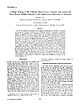 | | Journal (article/letter/editorial) | | Strata-BoundSulfideDepositsin the AppalachianPiedmontof Alabama JAMESF. TULL Departmento] Geology,The Florida State...centralregionas well. Introduction at Pyriton, Alabama, which have been studied in greatestdetail. IN...kilometers(Tull, 1978). The fault at the baseof this Alabama to near Cartersville in northwestern Geor- thrustnappedips...asalticlavaflowsthat werelocallyintermixed HATCHET CREEK-Mc GHEE SULFIDE ZDN • with basalticpyroclasticrocksand...features that would allow us to subdivide aroundthe Clay-TalladegaCountyline (Fig. 4); these them. They are |  | | Report (issue) | | aie! BARTLETT'S/27 FERRY FAULT } i GEORGIA ALABAMA sy .i % OP A iar an waeew ows mp ede eel (...CAROLINA ug 5; “A BARTLETT'S/.2 FERRY FAULT ? ALABAMA GEORGIA 50 . Lee 50 MILES SO KILOMETRES UNIVERSITY...this volume on the sulfide deposits of Georgia-Alabama. from does It has been the authors not involve...Appalachians in Paleorift the Southern Flank Alabama (Robert W. of Turkey Haven Schafer and J. Settings...Copper Anomaly at the Peachbottom Deposit, Alleghany County, North Carolina (John E. Callahan, J. Hatten Metal |  | | Book | | ____________________ ..... CHAPTER 11 Georgia 1 CHAPTER 12 Alabama 0 0 . . . . . . . . _ 3 VI 1 1 1 1 2 9...Newton, Wa l t o n , F a n n i n , F o r s y t h Alabama: C l a y, Cleburn, Coosa, Tallapoosa, C h i l t...i n , Dawson, Banks, Clayton, Lee, Tw i g g s Alabama: St. C l a i r , Lee, Shelby Pearls r a n k a s...e d S t a t e s w e r e t h e Tennessee a n d Alabama Rivers. N e w Jersey: L a k e Hopatcong, Greenwood...S t . Johns, Peace. Alabama: B l a c k Wa r r i o r, Coosa, N o r t h , Alabama, Locust, Tennessee, Tallapoosa |  | | Book | | 21:98100 Abstracts of the FM-TGMS-MSA Symposium on Azurite and other copper carbonates (chairman: K. Wenrich)...Iaria from the Howard-Montgomery quarry, Howard County, Maryland (by J. S. White) 25:53-54 AFGHANISTAN...Gibbs) 14:283-298 ALABAMA Iron phosphate mineral locality at Indian Mountain, Alabama (by H. Harwood) 5:241-244...phosphates of the Williams pegmatites, Coosa County, Alabama (by P. B. Leavens & T. A. Simpson) 6:66-73...first. Alabama (by H. Barwood & B. Hajek) 9:388391 Notable gold occurrences of Georgia and Alabama (by R |  | | Report (volume) | | character of ores____________________ Hartford County deposits__________________________ Simsbury (Newgate)...mine_________________________________ New Haven County deposits________________________ New York ____... Dorothy mine ______________^_-_____ Albemarle County (Southwest Mountain)_____________ 89 89 Triassic...Bentonville-Overall district________________ 101 Rappahannock County _.________________________ 101 Ambler property______________...Manassas Gap mine____________:____________ Page County _____^___________________________ Geology_____ |  | | Book | | Department of Geological Sciences Duluth MN 55812-2496 USA grapp@d.umn.edu ISBN: 978-3-540-78593-4 e-ISBN:...quartzite, Boulder Lake Reservoir, St. Louis County, Minnesota, USA . . . . . . . . . . . . . . . . . . . ... 86 Major obsidian deposits of the southwestern USA . . . . . . . . . . . . . . . . . . . . . 87 Basalt...Basalt hafted hammer from Lake Superior north shore, USA . . . . . . . . . . . 90 Hafted granite hammer from...Hopewell obtained mica from western North Carolina, USA. . . . . . . . . . . . . . . . . . . . . . . . . |  | Pan, Kuo-Liang, Overstreet, W.C., Robinson, Keith, Hubert, A.E., Crenshaw, G.L. (1980) Equivalent uranium and selected minor elements in magnetic concentrates from the Candle Quadrangle, Solomon Quadrangle, and elsewhere in Alaska. Professional Paper 1135. US Geological Survey doi:10.3133/pp1135 | Report (issue) | | control sample of magnetic concentrates from Hampton Creek placer, Nevada, for Ag, Bi, Cd, Co, Cu, Ni, Pb,...sample 300DL of magnetic concentrates from Hampton Creek placer, Nevada, for Ag, Bi, Cd, Co, Cu, Ni, Pb,...control sample of magnetic concentrate from Lyle Creek, North Carolina, for Ag, 131, V/Q., v/Of l^/Uf INI)...unsized subsamples of file number 3799 from Portage Creek placer, Alaska, for Ag, Bi, Cd, Pn Pn 'L™1, TMi...and in hematitic coatings on the magnetite, Jump Creek placer, Bendeleben quadrangle, Alaclra 4&lclOJXcl |  | | Report (volume) | | Umpleby.... The Yellow Pine mining district, Clark County, Nev., by J. M. Hill...... Survey publications...the red iron ores of east Tennessee, northeast Alabama, and northwest Georgia, by E. F. Burchard........near Barstow, Cal., by R. W. Pack.................. Clay in northwestern Montana, by C. M. Bauer...........sulphate in the Carrizo Plain, San Luis Obispo County, Cal., by U.S. Gale............................................. 428 Borate deposits in Ventura County, Cal., by H. S. Gale.................. 434 Potash |  | | Report (issue) | | MINES AND MINERAL RESOURCES OF TRINITY COUNTY, CALIFORNIA ^^^^gz^^^^sHi LIBRARY ^ tnSF DAVIS [... Mi+teCOUNTY CcUifi&isua By J. C. O'BRIEN, Mining Engineer...Retired and Geology California Division of Mines COUNTY REPORT 4 California Division of Mines and Geology...TABULATION OF MINES AND MINERAL RESOURCES OF TRINITY COUNTY 53 (3) 3 Illustrations Page Plate 1. Map...California with County Figure 3. Geologic of the mines of Trinity map County of Trinity County In pocket |  | | Report (issue) | | COLLABORATING STATE AGENCIES Geological Survey of Alabama, University, Ala. Department of :ty.lines, Mining...___ _ Resource potentiaL ____________________ _ Clay, by John W. Hosterman, Sam H. Patterson, J()hn W...Introduction __________________________ _ Miscellaneous clay and shale ____________ _ Types and occurrence ______________...______________ _ Resource potentiaL ________________ _ Fire clay _________ - _- _- - - - - - - - - - - - - - - -...potentiaL _____________ -_-Pottery and stoneware clay __________ ---Potassium-bentonite ________________ |  | | Report (issue) | | common materials as limestone, sand and gravel, and clay. Metallogenic maps are not resource maps; for in...3C45C5A4 BELl ZE 1 2 3 MOUNTAIN PINE RIDGE FIRST CREEK QUEBRADA CEIBO GRANDE BRITISH VIRGIN ISLANDS VIRGIN...LINDBERGH DUVERNAY METI SKOW MOUNT INVINCIBLE DUNGARVAN CREEK GYP FE HAL GYP GYP AU HAL HAL MBL GYP FE BRITISH...5 6 7 8 9 10 11 12 13 14 15 16 DULLIS (SQUAW) CREEK ALSEK RIVER (WINDY) O'CONNOR RIVER RAINY HOLLOW...(MOLLY) HOBOE CREEK (LAVERDIERE) MOUNT VAUGHAN (AlLIN-RUFFNER) ADANAC-ADERA (RUBY CREEK AREA) DAVENPORT |  | | Report (issue) | | 279 327 NAME FIRST CREEK MOUNTAIN PINE RIDGE QUEBRADA CEIBO GRANDE DUNGARVAN CREEK DUVERNAY FORGETMENOT...STARLIGHT RANGE SWIFT CREEK WATERWAYS ADAMS PLATEAU AREA ADANAC-AOERA (RUBY CREEK AREA) AFTON AND IRON...ARM MOLY AREA (B.C., ROUNDY CREEK, BELL) ALSEK RIVER (WINDY) ANKWILL CREEK (RAINBOW) ANTICLIMAX-ROCK ISLAND...ISLAND AREA ANYOX (HIDDEN CREEK AND BONANZA MJNE) APEX ARGONAUT MINE ASHLOO MINE ASITKA PEAK (ASITKA)...AREA ATLIN AREA ATNA RANGE BALL CREEK AREA BARRETT LAKE-EMERSON CREEK AREA (BARR, ETC) BARRINGTON RIVER |  | | Book | | Netherlands. Special regulations for readers in the USA - this publication has been registered with the Copyright...made in the USA. All other copyright questions, including photocopying outside of the USA, should be referred...Australia (Victoria and Tasmania), 40-45°N in the USA (Oregon and Wisconsin) and 55°N in Europe (Northern... colluvium, residual soil plus aeolian silt and clay). The classification based on these criteria is...B 3 0[1] Quartz stone-line clay (rainforest) Saprolite Alluvium Clay Saprolite I I I A 0 0 [1] |  | | Journal (volume) | | ready made out the State. At Forest City, Sierra county, to be thankful for a good deal. The telegraph...considered equivalent to the same. The basin of Slate creek, lying a few miles farther to the northwest, is...the country: On the Forest Hill divide, Placer county, where A remarkably good sample of a paper that...separates Bear river from Steep hollow in the same county constitutes another noted drift locality, the prominent...information. Wind Kiver peak and the head of Tory creek, to the far-away insects; but this one, with its |
|


