 | | Journal (article/letter/editorial) |
| Coeur d'Alene Mining District Basedon Ore Depositsand StructuralData EARL H. BENNETT Idaho Bureauof Mines...Mines and Geology,Morrill Hall, Universityof Idaho, Moscow,Idaho 83843 AND RAMESH VENKATAKRISHNAN Department...geologyand ore deposits. DURING 1979 the amount of silver mined since 1884 Our studypresentsthe resultsof...resultsof two suchreconin the Coeur d'Alene mining district in Idaho exstructions, one basedon the mineral depositsand...Potosi,Bolivia, making the Coeur d'Alene the premier silver-pro- other on a palinspasticreconstructionusing |
 | | Report (volume) |
| it helpful to refer to Survey Bulletin 507, "The mining districts of the western United States," and to...abundant, it may have been completely exhausted by mining or quarrying. Deposits of minerals of wide distribution...because they occur in sufficient quantity to warrant mining for their usual products but because they furnish...See Bauxite and Hallpysite. Asbestos. Tallapoosa County, with corundum deposits near Dudleyville; not found...commercial quantity or quality. Asphalt. Colbert County, small quantity has been shipped from near Leighton; |
 | | Book |
| PISTOLS i !?' A J.-. N ; 'jxt . 1 — \ MINING DISTRICTS and MINERAL RESOURCES of NEVADA by ...present authentic infor mation concerning the mining districts and mineral resources of Nevada. No comprehensive...United States Geological Survey in 1912. Plan. “Mining Districts and Mineral Resources of Nevada”, as...parts:—one on mining districts and the other on mineral resources. The section on mining districts is...but gives more extended descriptions and includes mining as well as geological information. The map which |
 | | Report (issue) |
| (CRIB) DATA FOR THE WALLACE 2° QUADRANGLE, NORTHERN IDAHO AND NORTHWESTERN MONTANA, PART A by G. J. Orris...U. S. Geological Survey Mail stop 920, National Center Reston, VA 22092 OR ' (202) 860-6455 FTS 928-6455... Stockholm Placer Triangle Mine Eclipse and Van Ness Placer Tucker Gulch Placers Quartz Creek Placer Mines...Channel Placer North Fork Claims Swastika Placer Bonanza Group Barite Mine Gildersleeve Mine Windfall...Windfall Creek Placer Meadow Creek Placer Mine Floodwood Creek Prospect Amended Sweeney, Amended Sunflower Sunrise |
 | | Book |
| stumble over a valuable nugget and stake your own mining claim? Indeed it to is, and author book Jay...prospecting, he points out, is in abandoned mining districts, where valuable mineral ores are present...commercial ores and secondary minerals by state, county, township, and geologic range. For easy identification...RANSOM 1875-1948 An to the Eastern '‘Schoolmarm” Mining Camps of the Old West I I a s I \ h K... CONTENTS Preface ix PART I 1 Introduction to Mining and Mineralogy 2 Preparation for Mineral Collecting |
 | | Report (volume) |
| SMITH, DIRECTOR 408 A RECONNAISSANCE OF SOME MINING GAMPS IN ELKO, UNDER, AND EUREKA COUNTIES, NEVADA.......................................... Secret Canyon shale............................................fracture zones in rhyolite......................... Placer deposits. ................................................................. Mountain ranges and mining districts................................................................ Midas or Gold Circle district........................................ Location |
 | | Report (issue) |
| FORTY-EIGHTH ANNUAL REPORT OF THE ‘MINING INDUSTRY. of IDAHO FOR THE YEAR ARTHUR CAMPBELL Inspector...ANNUAL REPORT OF THE MINING INDUSTRY of IDAHO FOR THE YEAR 19 2476 IDAHO AND PRODUCED COPPER IN...IN GOLD, SILVER, 1946—VALUED AT ARTHUR CAMPBELL Inspector of Mines MYRTLE ELLENSOHN Secretary LEAD...Governor of Idaho. Williams, Sir: In compliance with the provisions of Section 46111, Idaho Code Annotated...Conditions in Idaho Accidents, Description Fatal Accidents Silver Price Made Law Phosphate, Idaho Has Large |
 | | Report (issue) |
| the Coeur d'Alene mining district, Shoshone County, Idaho consists principally of galena-sphalerite- and...tetrahedrite-veins that have produced significant amounts of silver, lead, and zinc with lesser amounts of copper,...The district has produced in excess of 31,000 metric tons of silver, more than any other mining district...considered to be a distinct type unique to the district. The U.S. Geological Survey (USGS) has not attempted...undiscovered resources of these metals in the district, or in other regions favorable for the discovery |
 | | Book (volume) |
| Most specimen collecting is done in the Lead-Zinc mining dists. of northwestern Illinois, the glacial drift...600 to 800 feet thick in the north. ALEXANDER COUNTY FAYVILLE, area stream gravels⎯agate, jasper, rare...⎯agate, jasper; d RR siding of Clay⎯agate. CALHOUN COUNTY AREA, shores of the Mississippi R., in the Warsaw...crystals). CRAWFORD COUNTY PALESTINE, area deposits⎯Siderite. EDWARDS COUNTY AREA, T. 1 S, R. 10 E...deposits⎯Siderite. FULTON COUNTY FARMINGTON, W 6 mi. on Rte. 116 to the Rapatee No. 5 strip mine⎯pyritized gastropods |
 | | Report (issue) |
| Appendix A **~""~~"* "* *** *"* * » Table Table 1. District descriptions . .-.-.-. . -.-. . . . .-. .-. <...Province. These areas include past and present mining and prospecting localities as well as areas of...map are not legal mining district boundaries and may include more than one district as well as adjacent...formations (Stewart and Carlson, 1978) in which mining sites and metallic occurrences are located. Information...Information on the locations were obtained from the county reports and other literature. Even though the individual |
 | | Book (volume) |
| chalcedony, jasper and gem petrified wood. BUFFALO COUNTY KEARNEY, area gravel bars and pits along the Platte...townagate, chalcedony, jasper, petrified wood. CASS COUNTY WEEPING WATER, SE, on rd. to Nehawka, in the Snyderville...chalcedony, jasper, fossils. CHERRY COUNTY VALENTINE, in the Sandhills county along the Niobrara R. and Minnechaduza...gem qualityagatized and opalized wood. DAWES COUNTY CHADRON, in N part of Co. and as far W as Crawford...woods, etc. DAWSON COUNTY GOTHENBURG, in sand pitspetrified palm wood. DEUEL COUNTY CHAPPELL, all regional |
 | | Book |
| at aks SUMMIT AGold Rush History of Summit County, Coldrado By Mary Ellen Gilliland Copyright 1980... Colorado 80498 iv For the people of Summit County, past and present, and particularly, for Larry...Nineteen Summit Map Bibliography Index This Is Summit County Before the Rush Began: The Rocks That Made the...Century-Old Silver Town Mining: The Pick, Pan and Blasting Powder Route to Riches Breckenridge Mining: Gulches...Gulches of Gold Ten Mile Mining: Storied Silver Canyon Montezuma Mining: Treasure Atop the Rockies Summit |
 | | Report (issue) |
| and 1916. Bulletin No. 10. Value €If Ores . . Mine Sampling and the Commercial Bulletin No. 11. Descriptive...Geological Survey and in the journals dealing with mining and geology, but this material is widely scattered...and Mining Journa1. M. & S. P.-Mining and Scientific Press. 2 INTRODUCTION M. & E. W .-Mining and...Min.-Mines and Minerals. S. L. M. R.-Salt Lake Mining Review. In order to give proper credit to the courses...districts, under the general bibliography for the county or state and under the discussion of a particular |
 | | Report (issue) |
| Topography, Geology and Mineral Resources.. Douglas County— Location and Topography.. Geology and Ore Deposits...Highways_____ Production............................... Mining Districts— Buckskin (Smith Valley). Gardnerville.......... Red Canyon (Silver Lake)......... PUBLISHED QUARTERLY BY THE Wellington (Silver Glance)........ U n iv e r s it y o f N e v a d a irmsby County— RBNO, NEVADA Location and Topography................. Nevada, as second-class m atter under A rt of Mining Districts— Congress, July 16, 1894. Acceptance |
 | | Book |
| NN 419-3 Nevada; a 03 G ps 127)oO to the Silver state The few rules of the library are for the...ae NEVADA A Guide to the Silver State mv DA A GUIDE TO THE SILVER STATE a Compiled by workers...expressed for the courtesies extended by the Washoe County and University of Nevada libraries. The staff is...States Department of Agriculture; G. H. Hansen, District Agent of the Biological Survey; Louise Lewers...principal of the Winhemucca School District; George P. Annand, district judge, Ely; Lester Mills, instructor |
 | | Report (volume) |
| GEORGE OTIS SMITH, DIRECTOR BULLETIN 594 SOME MINING DISTRICTS IN NORTHEASTERN CALIFORNIA AND NORTHWESTERN...GEORGE OTIS SMITH, DIRECTOR BULLETIN 594 SOME MINING DISTRICTS IN NORTHEASTERN CALIFORNIA AND NORTHWESTERN...deposits 2 22 Early Tertiary ( ?) deposits 2 23 Gold-silver deposits 2 23 Deposits of the early Tertiary (...of the late Tertiary epoch of metallization 23 Silver-lead deposits 2 25 2 Copper deposits 26 Deposits...of the ore deposits 2 27 30 Mining districts 2 Hayden Hill, Lassen County, Cal 2 30 30 Location and accessibility |
 | | Report (issue) |
| precious-metal deposits in the Battle Mountain mining district UNITED STATES GOVERNMENT PRINTING OFFICE...__________ Cambrian System_______________________ Scott Canyon Formation_ _ _ _ _ _ _ _ _ _ _ _ Ordovician System...Formation____________ Havallah Formation________________ Scott Canyon Formation____________ Harmony Formation________________...___________________ ---- ___ --- ____ Valm y and Scott Canyon blocks__________________ Dewitt block____ ____...-----------Gold-silver deposits ____ - _ - - - - - - - - - - - - - - - - - - Lead-zinc-silver deposits _____ |
 | | Report (issue) |
| . . . . . . . . . . . . . . . . . . . Stevens County..................... ... . . . . . . . . . . ....Northport District. .... . ........ . .. ... . . . .. . . . ............ . Myers Fa.Us District . . . .... . . . . . . . . . . . . . . . . Fla.t C1·eek District . . . . . . . . . . . . . . . . . . . . . . .... . . . . . . . . . . . . . . . . . Colville District . . . . . . . . . . . . . . . . . . . . . . . ..... . . . . . . . . . . . . . . . . . Chewela.h,District . . . . . . . . . . . . . . . . . . . . . . . |
 | | Report (issue) |
| . . . . . . . . . . . . . . . . . 1 Chapter I. Mining Districts of Counties and the State of Utah. .... . . . . . . . . . . . . . . . . . . . . . . 1 County Listings. . . . . . . . . . . . . . . . . . . ... . . . . . . . . . . . . . . . . 1 Chapter II. Mining Districts of Utah . . . . . . . . . . . . . . .... . . . . . . . 4 Mineral Localities Listed by County . . . . . . . . . . . . . . . . . . . . . . . .... . . . . . . . . . . . . . . . . . . 7 Beaver County . . . . . . . . . . . . . . . . . . . . . . . |
 | | Report (volume) |
| Western Sierra C:ourlty, New Mexico, Suggested by Mining Distri.cts, Ceologyt and c ·eochemicaf, Anomalies... Mineral Belts in Western Sierra County, New Mexico, Suggested by Mining Districts, Geology, and Geochemical...information on mineral belts in western Sierra County, New Mexico, indicates many new areas favorable...Reports Section U.S. Geological Survey Federal Center Box 25425 Denver, CO 80225 Library of Congress...1921Mineral belts in western Sierra County, New Mexico, suggested by mining districts, geology, and geochemical |
 | | Report (issue) |
| ...... ·- ......... . J,5 Historical sketch of mining and smelting in New Mexico....... . . . . . . ....... : . .............. - ........ .. . . T~os County, by L. C. Graton and W ..Lindgren ..... ................. . . , ... -.. . Rio Hondo. (Twining) district . . . . . . . . . . . . . ......................::.:::.::: ::: :::: :: ':::: :: ::::. Red River district. ..................•......... -~ . . ...........·::-; : : :. ::.·.i?:5.•.:...,. .... Black.Copper mine ........ ............. ~ ... .. . .... ·....... |
 | | Map |
| resource map 24 Mining Districts and Prospect Areas in New Mexico by Virginia T. McLemore edited by...New Mexico Institute of Mining and Technology Socorro, New Mexico 2017 Mining Districts and Prospect...Resources Nelia Dunbar, Director and State Geologist Mining Districts and Prospect Areas in New Mexico by Virginia...Maureen Wilks A division of New Mexico Institute of Mining and Technology Dr. Stephen G. Wells, President...1800s from 246 mining districts and prospect areas (excluding coal, oil and gas). Today, mining is still an |
 | | Report (issue) |
| INDEX OF MINING PROPERTIES IN COCHISE COUNTY., ARIZONA by Stanton B. Keith Geologist Bulletin 187...research and provide information about exploration. mining. and metallurgical processes that are needed in...Technology Branch J. Brent Hiskey Assistant Director Mining and Mineral Resources Researchlns~tute Orlo E...Affirmative Action Employer. INDEX OF MINING PROPERTIES IN COCHISE COUNTY, ARIZONA by Stanton B. Keith Geologist...produce copper. The Warren (Bisbee) mining district, which includes this mine, yielded 167,242,000 tons of ore |
 | | Journal (issue) |
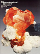
| paragenesis of the Little Three mine pegmatites, Ramona district, San Diego County, California ...............Geological Survey Box 25046, M .S. 905 Denver Federal Center Denver, Colorado 80225 In recent decades the science...Geological Survey, M. S. 905 Box 25046 Denver Federal Center, Denver, Colorado 80225 Louis B. Spaulding, Jr...plus an interesting range o f rare species. The mine, first opened in 1903, continues to produce fine...Three mine is one of several mines located on the Little Three property in the Ramona district, San Diego |


