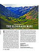
 | | Journal (article/letter/editorial) | | 20:52 13 January 2015 Mineralogy of the Eldorado Mine YA N K E E B O Y B A S I N , O U R AY C O U N T...the name, as almost every major mining camp had a vein, claim, or mine with that name. This article details...mineralogy of the Eldorado mine in the San Juan Mountains of southwestern Colorado, one of the many mines...Eldorado mine is located about 8.6 miles southwest of Ouray, Colorado, near the head of Yankee Boy Basin...Basin in the Sneffels mining district. The portal to the mine is at an elevation of 11,600 feet and is situated |  | | Journal (article/letter/editorial) | | Metals Mine ,; Pilot Mine , ; ,-e Grizzly Bear Mine ~ Silver Link Mine ~ Mountain Monarch Mine o TOM...Bird Mine Road P.O. Box 586 Ouray, Colorado 81421 Telluride ~ Oyama Mine ,-e Titusville Mine Downloaded...Mineralogy of the San Juan Mountains o , Southwestern Colorado Unless otherwise noted, mineral photography by..."Microminerals of the San Juan Mountains, Southwestern Colorado" (Rosemeyer 1989) was the topic of the first Through...discoveries. Pilot Mine Yankee Boy Basin is located approximately 8 miles southwest of Ouray and in the |  | | Book | | MINES AND MINERALS OF THE GREAT AMERICAN RIFT (COLORADO-NEW MEXICO) Sine —_—< ¢ te om At _SHT 40...MINES AND MINERALS OF THE GREAT AMERICAN RIFT (COLORADO-NEW MEXICO) Richard Walker Holmes and Marrianna...Mines and minerals of the Great American Rift (Colorado-New Mexico). Bibliography: p. Includes index...index. 1. Mines and mineral resources—Colorado. 2. Mines and mineral resources—New Mexico. I. Kennedy, Marrianna...enter must be obtained to prevent trespass. Old mine workings are dangerous and entering underground |  | | Report (issue) | | . . . . . . . . . . . . . . . . . 1 Chapter I. Mining Districts of Counties and the State of Utah. .... . . . . . . . . . . . . . . . . . . . . . . 1 County Listings. . . . . . . . . . . . . . . . . . . ... . . . . . . . . . . . . . . . . 1 Chapter II. Mining Districts of Utah . . . . . . . . . . . . . . .... . . . . . . . 4 Mineral Localities Listed by County . . . . . . . . . . . . . . . . . . . . . . . .... . . . . . . . . . . . . . . . . . . 7 Beaver County . . . . . . . . . . . . . . . . . . . . . . . |  | | Journal (issue) | | - - - - - - - - - - - Mineral Collections 1n Colorado A Supplement to The Mineralogical Record November-December..."Smithsonian packet," Smoky Hawk claim, Florissant, Colorado. Collected in 2008; Dorris Family collection;...certificates for mines in the Cripple Creek District, Colorado, in 1898 and 1901. Sponsorship: This special...Collecting in Colorado The Collections: Mel & Pam Bersch Ryan Bowling Ralph Clark Colorado School of Mines...Kile Brian Kosnar Bryan & Kathryn Lees Ian Merkel Mining Hall of Farne, Steve Whittington curator Nick North |  | | Report (issue) | | COLORADO GEOLOGICAL SURVEY BOULDER R. D. GEOqGE, State Geologi.t BULLETIN 22 MINERAL DEPOSITS OF THE...oozi5137 EAME"S BROS, STATE PRINTERS FOR COLORADO DENVER. COLORADO GEOLOGICAL B O A R D His Excellency...Shoup George Norlin Governor of Colorado President University of Colorado Victor C. Aldersox.. Charles...TRANSMITTAL State Geological Survey, Uxiversity of Colorado, October 28, 1920. Governor Oliver H. Shoup. Chairman...honor to transmit herewith Bulletin 22 of the Colorado Geological Survey. Very respectfully, R. D. George |  | | Journal (article/letter/editorial) | | by [Gazi University] at 01:28 05 January 2015 Colorado Mineral Treasures from The Field Museum Chicago...article highlights some of the more interesting Colorado specimens there, along with historical background...Industries and Manufactures, and products of the soil, mine, and sea.” In 1893, Chicago had a population of...surrounded the Great Basin. Among the buildings were Transportation, Mines and Mining, Electricity, Manufactures...structures on the grounds included the State of Colorado Building. Many items appeared at the exposition |  | | Book (volume) | | ...........................................59 Colorado ...............................................................548 Table of Maps Page Alabama County Map ...................................................................................4 Alaska County and Stream Map ..................................Co. Mining Districts ............................................................22 Arizona County Map.........................23 Arizona – Cochise Co. Mining Districts .................................... |  | | Book (volume) | | ...........................................47 Colorado ................................................rights, so remember you were told. If in doubt, a county map will tell you who the legal owner is. Good...gemmy qualities for cutting and polishing. AUTAUGA COUNTY PRATTVILLE, N. 6 mi., and just E of the Birmingham...were well known to prehistoric Indians.) BARBOUR COUNTY BAKER HILL, SE 1 mi. : 1 in a deep ravine, as a...deep red to variegated⎯ocher. BIBB COUNTY GENERAL AREA: c county gravel pits along the Cahaba R.⎯gemmy |  | | Book (volume) | | ...........................................47 Colorado ................................................rights, so remember you were told. If in doubt, a county map will tell you who the legal owner is. Good...gemmy qualities for cutting and polishing. AUTAUGA COUNTY PRATTVILLE, N. 6 mi., and just E of the Birmingham...were well known to prehistoric Indians.) BARBOUR COUNTY BAKER HILL, SE 1 mi. : 1 in a deep ravine, as a...deep red to variegated⎯ocher. BIBB COUNTY GENERAL AREA: c county gravel pits along the Cahaba R.⎯gemmy |  | | Journal (article/letter/editorial) | | specimens, are either inaccessible or are in closed mining districts, or are closed for political reasons...City-D~Lamar Mining Dlstricts / J\. I,' -r-, - L..... ~ rl.. kl \ , 50 I 100 I Miles old mining and...scientific significance. In this index, the better known mining districts that have produced many high-quality...across, on blue thomsonite. Lucky Peak Dam, Ada County; Lanny Ream specimen and photo. Figure 3 (below)...cut near Pinehurst, Adams County; Lanny Ream specimen and photo. Ada County Lucky Peak Dam, on east side |  | | Journal (issue) | | Tue largest crystal measures 3 cm Heights mine, Weardale, County Durham, England. Stuart Strife collection;...photo Backcover: (upper left) Elbaite, 4.5 cm, Sapo mine, Goiabeira, Minas Gerais, Brazil; Gus Eitler collection;...right) Elbaite, 7.8 cm, Himalaya rnine, San Diego County, California; Kevin Brown collection; Jeff Scovil...Tree Root pocket, Two Point claim, Teller County, Colorado; Karl Warning collection; Jeff Scovil photo...interest-gauging emails, Stuart Strife proposed a pilot meeting tobe held on Saturday May 1, 2004 at the |  | | Journal (issue) | | Dam gold prospect is located in central Dickinson County, Michigan, approximately ten kilometers north of...the dominant exposed bedrock in this part of the county. Excavated near the tum of the 20th century, the...obvious even when visiting some of the Garland County mines. I also planned to do some Magnet Cove collecting...Locations - TUCSON &FOSSIL SHOW™ APRIL 25 - 27, 2008 COLORADO MINERAL MINERAL SHOW Holiday Inn - Bristol Plaza...CARTERSVILLE, * Mineral & Fossil Marketplace COLORADO MINERAL FOSSIL SHOW SEPTEMBER12 - 14, 2008 |  | | Report (issue) | | description of the geology, mining history, and production of the major gold-mining districts in 21 States...relations ---------------------------History of gold mining and trends in production_ J\labama -----------...--------------Cleburne County ----------~----------------- Tallapoosa County --------------------------Alaska...------------------Cochise County -----------------------------Gila County --------------------------------Greenlee...ee County ----------------------------R[aricopa County ----------------------------R[ohave County -- |  | | Report (issue) | | _________________ ___. Nevada ___________ Elko County. - ______ ... _ Star mine, Harrison Pass _____ ____ Pag« 59...63 Good Hope barite mine, Tuscarora Range _____ _ ._. ________ Humboldt County Golconda manganese-tungsten...Ltd., mine...... --_--______.______ Lincoln County__-__-----_-----_-----___ Tern Piute district.........________..__ Nevada Scheelite mine.. _ ______ Hooper No. 2 mine __ _____ _ _ Yankee Girl mine_______________...Gunmetal mines, Pilot Mountains_____________.____ Desert Scheelite mine..... _______ Gunmetal mine _ ___________ |  | | Book (volume) | | instance, a single Spodumene crystal from the Etta Mine near Keystone on the east side of the Mount Rushmore...beds, excavations, etc.Selenite roses. BRULE COUNTY AREA: in the Oacoma zone of the Pierre Fm. On Elm...gray Barite rosette up to 5 or 6 inches. CAMPBELL COUNTY MOUND CITY, W to the Missouri R., regional hillsides...gravels, etc.petrified wood, wood opal. CORSON COUNTY LITTLE EAGLE: area ridges, slopes, stream beds...Hounds in the United States CUSTER COUNTY AREA: The November Mine, 1.2 mi. SE of the Needles Eye Tunnel |  | | Journal (article/letter/editorial) | | Geochemistry and Stable Isotopes of the Flooded Underground Mine Workings of Butte, Montana CHRISTOPHER H. GAMMONS...Butte, Montana 59701 Abstract Over a century of mining and smelting of the world-class porphyry lode ore...most acidic mining pit lakes, Butte is host to over 16,000 km of flooded underground mine workings. Of...Of the more than 60 mine shafts that have historically operated in Butte, approximately one dozen are...geochemistry of the mine shaft waters is zoned and roughly coincides with a district-wide zonation in hydrothermal |  | | Report (volume) | | ............................................. Colorado........................................................................................ 102 District of Columbia ....................................to refer to Geological Survey Bulletin 507, "The mining districts of the western United States," and to...abundant it may have been completely exhausted by mining or quarrying. Deposits of minerals that are widely...because they occur in sufficient quantity to warrant mining for their usual products, but because they furnish |  | | Report (volume) | | GEORGE OTIS SMITH, DIRECTOR BULLETIN 594 SOME MINING DISTRICTS IN NORTHEASTERN CALIFORNIA AND NORTHWESTERN...GEORGE OTIS SMITH, DIRECTOR BULLETIN 594 SOME MINING DISTRICTS IN NORTHEASTERN CALIFORNIA AND NORTHWESTERN...of the ore deposits 2 27 30 Mining districts 2 Hayden Hill, Lassen County, Cal 2 30 30 Location and accessibility...filling 3 42 CONTENTS. Mining districts—Continued. Hayden Hill, Lassen County, Cal.—Continued. Ore deposits—Continued...shoots Milling High Grade district, Modoc County, Cal Location History of mining Accessibilty Previous descriptions |  | | Journal (issue) | | R. Kampf Natural History Museum of Los Angeles County George Robinson National Museums of Canada Arthur...SPECIMENS from the collection of the Geology Museum, Colorado School of Mines. See page 242 for a full description... All rights reserved. notes fromthej EDITOR COLORADO-III Here we are with our third special issue devoted...devoted to the mines and minerals of Colorado. As most long-time subscribers know, the first in the series...about $200 on the out-of-print market. The second Colorado issue was vol. 10, number 6 (1979), and we still |  | | Journal (issue) | | COVELLITE crystal cluster, 3 cm across, From the Leonard mine, Butte, Montana. Frederick H. Pough collection;...anywhere. Handsome specimens of barite, quartz, rhodochrosite, silver, and numerous other species have been...(rightbackground) mines, Butte, ca. 1965. World Museum of Mining photo. 6 The Mineralogical Record, volume 33...hole.” The ground in the Butte mining camp, especially in the Kelley mine, was just full of vug holes ...World Museum of Mining is also located in Butte, at the site of the old Orphan Girl mine. . . . So wrote |  | | Book | | stumble over a valuable nugget and stake your own mining claim? Indeed it to is, and author book Jay...prospecting, he points out, is in abandoned mining districts, where valuable mineral ores are present...commercial ores and secondary minerals by state, county, township, and geologic range. For easy identification...RANSOM 1875-1948 An to the Eastern '‘Schoolmarm” Mining Camps of the Old West I I a s I \ h K... CONTENTS Preface ix PART I 1 Introduction to Mining and Mineralogy 2 Preparation for Mineral Collecting |  | | Journal (article/letter/editorial) | | to collectors. Many specimens were produced when mining districts were active in the late 1800s through...districts mentioned below, most historically active mining districts in the state have been inactive for decades...exploration activity occurs on an irregular basis. Beaver County MINERAL COLLECTING IN THE STATE of Utah has undergone...article does not give permis- Lincoln district: The Creole mine, located at the south end of the Mineral...east side of the range. Pine Grove district: This old mining district is the site of a deeply buried porphyry |  | | Journal (article/letter/editorial) | | Friends of Mineralogy, and especially the Great Basin Chapter, for their foresight and enthusiasm in initiating...Clark County. Walt Lombard0 specimen, Jeff Scovil photo. Churchill County Chalk Mountain District Chalk...Chalk Mountain mine: calcite, cerussite, chlorargyrite, descloizite, galena, hemimorphite, leadhillite,...scheelite, vanadinite, wulfenite Corral Canyon District Various mines and prospects: anatase, rutile,...Quartz, 14.2 cm across, Newbeny Mountains,Clark County. Steve Scott specimen, Jeff Scovil photo. Figure |  | | Report (issue) | | GEOLOGY AND ORE DEPOSITS OF TILE LEADVILLE MINING DISTRICT, COLORADO BY S. F. EMMONS, J. D. IRVING, AND G...anticline _ Origin of the Iron-Mikado fault 61 Colorado Prince anticline _ group _ 95 61 Mosquito Gulch...fold-fault _ Faults in the eastern part of the district 95 62 Kokomo syncline_ Faults southeast_ of _..._ Leadville 62 the_ Fryer Hill folds _ 62 district _ 95 Warping and drag along normal faults, _ _ _ 96...103 66 and Mike faults _ Iron Hill _ 103 66 Tucson mine _ Area between Iron and Adelaide faults_ _ _ Yak_ |
|


