| Locality type: | Mine |
| Classification |
|---|
|
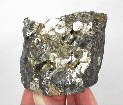
| Species: | Ilmenite |
| Formula: | Fe2+TiO3 |
| Confirmation |
|---|
|
| Validity: | Believed Valid |
| Associated Minerals Based on Photo Data: |
|---|
|
| Muscovite | ⓘ4 photos of Ilmenite associated with Muscovite at this locality. |
| Data |
|---|
|
| Mineral Data: | Click here to view Ilmenite data |
| Locality Data: | Click here to view Cromley Mine, Saluda County, South Carolina, USA |
| Photo Gallery | View Gallery (2 photos) |
| Data Identifiers |
|---|
|
| Mindat Occurrence Record ID: | 488009 |
| Long-form Identifier: | 1:3:488009:7 |
| GUID (UUID V4): | 0796b320-6dde-4204-af79-1e28b0146ff9 |
| Nearest other occurrences of Ilmenite |
|---|
|
|
| 48.6km (30.2 miles) | ⓘTwelve Mile Creek, Lexington County, South Carolina, USA |
| 55.9km (34.7 miles) | ⓘSouth Rabon Creek, Laurens County, South Carolina, USA |
| 56.3km (35.0 miles) | ⓘHarleys Mill Pond, Lexington County, South Carolina, USA |
| 58.5km (36.3 miles) | ⓘRed Bank Creek, Lexington County, South Carolina, USA |
| 66.2km (41.2 miles) | ⓘHorse Creek (Hollow Creek), Aiken County, South Carolina, USA |
| 66.2km (41.2 miles) | ⓘUnidentified Mine (Horse Creek Mine; MRDS - 10080088), Aiken County, South Carolina, USA |
| 68.5km (42.6 miles) | ⓘColley Mine, Lincolnton, Lincoln County, Georgia, USA |
| 70.9km (44.0 miles) | ⓘCongaree River, Lexington County, South Carolina, USA |
| 71.9km (44.7 miles) | ⓘAiken County deposit, Aiken Kaolin Mining District, Aiken County, South Carolina, USA |
| 73.4km (45.6 miles) | ⓘCalhoun Falls, Abbeville County, South Carolina, USA |
| References |
|---|
|
|
| Reference Search (possible matching items) |
|---|
 | | Catalog/List | | limonile ........... Utah Toelle County, Gold Hill, Gold Hill mine ~ransparent micro crystals on gossen...Copper aluminum silicate Arizona Pima County, Ajo, New Cornelia mine Sky blue micro xls and coatings on...Derby mine White xlline lamellar mass with minor lepidolite . Virginia Amelia, Rutherford mine !r2 Lustrous...cerium aluminum silicate California Los Angeles County, Pacoirna Canyon Large black tabular crystals in...basic sulfate of aluminum and potassium Utah .Piute County, Tushar Mountains, Marysvale ----i'>ink crystalline |  | | Report (volume) | | Rattlesnake Quadrangle Bearpaw Mountains Blaine County, Montana By B. C. HEARN, JR., W. T. PECORA, and...RATTLESNAKE QUADRANGLE BEARPAW MOUNTAINS, BLAINE COUNTY MONTANA By B. C. HEARN, JR., W. T. PECORA, and...An east-trending complexly faulted zone on the south flank of the arch has structural patterns similar...of the main volcanic fields which lie north and south of the arch west of this quadrangle. The zone contains...particularly indebted to members of the Boards of Blaine County School Districts 14 and 67 for permission to use |  | | Journal (article/letter/editorial) | | reserve e s t i m a t i o n at the Bakhar Field, South Apsheron, Azerbaijan, SSR, p. 245-249. Peters, Douglas...Short Note - ITHERM: a BASIC program for magnetite-ilmenite thermometry, p. 307-314. Rock, Nicholas M.S.,...Digital analysis of lineaments a test study on South India, p. 549-559. - Hagens, A l e x a n d e r...Corrigendum ITHERM: a BASIC program for magnetite-ilmenite thermometry, Computers & Geosciences, v. 17, no...between two geographic features, p. 989-1001. Cromley, Robert G., Principal axis line simplification |
|


Cromley Mine, Saluda County, South Carolina, USA