 | | Report (volume) |
| DIRECTOR BuiiIiETIN 574 MINING DISTRICTS OF THE DILLON QUADRANGLE, MONTANA AND ADJACENT AREAS BY ALEXANDER................................................. Mining districts...................................................................................... Mining development. ...................... .. - - ' -..................................... 18 Placer mining....... ~................................................................ 20 Present status of mining .....:........................................ |
 | | Journal (article/letter/editorial) |
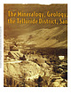
| house. Photo hy Uycrs, CB.1904. courtcs\ Ouraj County Historical Society. Volume 75, November/December...campaign (Nevins Figure 2. Map of the Telluride district showing the principal veins, adits, and shafts...researches Colorado ‘s geology, mineralogy, and mining history, is part owner of FRS Geotech, Inc., an...historic preservation efforts in the Leadville mining district. Downloaded by [UZH Hauptbibliothek / Zentralbibliothek...convention. Colorado’s silver interestsdomposed of mine, milling, and smelter entrepreneurs; managers, professionals |
 | | Report (issue) |
| deposit. Table 4, part B, gives an alphabetic list of mine and properties followed by the deposit name. CHARACTERISTICS... Sulfides likely to be present include pyrite, galena, sphalerite, and arsenopyrite (Berger, 1986). These...deposits used in Table 1 may represent a major mine, district name, or local town name or other prominent... Pyrrhotite appears to be been reported in just a single mine in the East Belt of the Sierra Nevada foothills...veins" in the Meguma Group deposits, Nova Scotia. Galena is listed third by Junner (1921) in the Victoria |
 | | Report (issue) |
| maximum depths, target areas, and overall lengths of mine workings for use in environmental assessment. The...target area of 160 hectares (fig. 8). Depth of mining in known deposits range from 31 to 915 m. The geometric... Eighty percent of the deposits have subsurface mine workings lengths between 1,100 and 5,900 m (fig...reported, or, in the case of zinc, possibly avoided in mining. Descriptions are commonly incomplete. Nearly all...veins have been a favored target for smallscale mining and can occur in large numbers scattered over a |
 | | Journal (issue) |
| KRISTALLE Est.1971 Laguna Beach, California, USA • Tel: +1 949 494 5155 • Email: info@kristalle.com... Gressman tom.gressman@minrec.org The Tintic District: Juab and Utah Counties, Utah...................COVER: CLINOCLASE, 3.9 cm, from the Mammoth mine, Tintic District, Utah. Rock Currier collection; Jeff Scovil...sample of a pascoite group mineral at a mine in Grand County, Utah. Died, Alex Earl, 26 Jayson Alexander...over the American West. A trip to the Blue Bell mine near Baker, California, in 2016 was particularly |
 | | Report (issue) |
| INDEX OF MINING PROPERTIES IN COCHISE COUNTY., ARIZONA by Stanton B. Keith Geologist Bulletin 187...research and provide information about exploration. mining. and metallurgical processes that are needed in...Technology Branch J. Brent Hiskey Assistant Director Mining and Mineral Resources Researchlns~tute Orlo E...Affirmative Action Employer. INDEX OF MINING PROPERTIES IN COCHISE COUNTY, ARIZONA by Stanton B. Keith Geologist...produce copper. The Warren (Bisbee) mining district, which includes this mine, yielded 167,242,000 tons of ore |
 | Morris, H.T., Lovering, Thomas Seward, Mogensen, A.P., Shepard, W.M., Perry, L.I., Smith, S.M. (1979) General geology and mines of the East Tintic mining district, Utah and Juab counties, Utah, with sections on the geology of the Burgin mine and the geology of the Trixie mine. Professional Paper 1024. US Geological Survey doi:10.3133/pp1024 | Report (issue) |
| General Geology and Mines of the East Tintic Mining District, Utah and Juab Counties, Utah GEOLOGICAL SURVEY...General Geology and Mines of the East Tintic: Mining District, Utah and juab Counties, Utah By H. T. MORRIS...LOVERING With sections on THE GEOLOGY OF THE BURGIN MINE By A. PAUL MOGENSEN, W. M. SHEPARD, H. T. MORRIS... and S. M. SMITH and THE GEOLOGY OF THE TRIXIE MINE By A. PAUL MOGENSEN, H. T. MORRIS, and S. M. SMITH...highly productive silver, gold, and base-metal mining district in the east-central Great Basin UNITED STATES |
 | | Report (issue) |
| zinc, tungsten, and copper. In 1896 world-renowned mining engineer Thomas ''T.A." Rickard called the San...San Juans one of Colorado's four great mining regions along with Leadville, Cripple Creek, and Central City...during the eighteenth century, were the first to mine in the San Juans. One of the earliest recorded expeditions...Above: August sunrise on middle Blue Lake, Ouray County Photo Jack Brauer/WideRange Photo LLC, 2010 Facing...discovered, mines were opened, and by 1874, small mining camps had begun to appear. The towns of Silverton |
 | | Journal (article/letter/editorial) |
| Mineralized Veins and Brecciasof the Cripple Creek District, Colorado TOMMY B. THOMPSON, ALAN D. TBIPPEL,...The vein depositsas exemplifiedby thoseof the Ajax mine cut Precambriancrystalline rocksandTertiary rocksof...highersalinitiesfoundin the upper 300 m of the Ajax mine levels;the fluidswereboilingandcontained CO•...pears to have headed on the Cripple Creek volcanic district,almost21 milliontroy ounceshavebeenreerosiona...suchdepositby The SilverStateMiningCorporation have district. (Lewis,1982) atteststo the viabilityof suchdeposits |
 | | Report (issue) |
| GEOLOGY AND ORE DEPOSITS · OF THE TINTIC MINING DISTRICT, UTAH BY WALDEMAR LINDGREN AND G. F. LOUGHLIN...rocks-Continued. Ordovician system .................. . Ajax limestone (including the Emerald dolomite member)....... . PART II. History of mining 'and· metallurgy in the Tintic district, by V. C.l!eikes ............water: .. ~.~~ ............... . Drainage of the district ....-... ·......... . Mineralization ...........Channel of the Gemini Chief mine ............................. . 205 mine·--------------------------------- |
 | | Report (issue) |
| Replacement Deposits Part II Gold in the Tintic Mining District, Utah By HALT. MORRIS Gold Deposits in the...Bird Mining Districts, San Juan Mountains, Colorado By FREDERICKS. FISHER Gold in the Alma Mining District...R. SHAWE Precious Metals in the Leadville Mining District, Colorado By TOMMY B. THOMPSON Part I is Chapter...bibliographies. Contents: pt. 1. Bald Mountain gold mining region, northern Black Hills, South Dakota / by...Tintic Mining District, Utah / by Hal T. Morris. Gold in the Sneffels-Telluride and Camp Bird mining districts |
 | | Book |
| PISTOLS i !?' A J.-. N ; 'jxt . 1 — \ MINING DISTRICTS and MINERAL RESOURCES of NEVADA by ...present authentic infor mation concerning the mining districts and mineral resources of Nevada. No comprehensive...United States Geological Survey in 1912. Plan. “Mining Districts and Mineral Resources of Nevada”, as...parts:—one on mining districts and the other on mineral resources. The section on mining districts is...but gives more extended descriptions and includes mining as well as geological information. The map which |
 | | Report (volume) |
| study of parts of the Tintic and North Tin tic mining districts UNITED STATES GOVERNMENT PRINTING OFFICE...the Tintic mining district and the southwestern part of the North Tintic n1ining district. The rocks...and is characterized by sagebrush (A rte'lnisia), rabbit brush ( 0 hry8othmnnus), juniper (Juniperus utahensis...mines of the Tintic, East Tin tic, and North Tintic mining districts. It joins the Eureka quadrangle on the...Round Knoll and Packard Peak; the East Tintic mining district is entirely within the Eureka quadrangle. The |
 | | Journal (article/letter/editorial) |
| Columbia-Washington, (3) (eastern) Oregon-Idaho-(western) Montana, (4) Colorado-NewMexico, (5) Nevada-southern California...Rate (t.p.d.)x BritishColumbia 1967 46,000,000 Mine Alice (B. C. Molybdenum) 8,000 Company British...A. 4o World War I stimulusbroughtthe Climax mine into production and in 1919 fissure-veindepositswere...Elaborate Deposits Breccia pipe ß Boss Mtn. + ß Mine + Importan1Prospect Gem + Lucky Ship Multiple...multiple intrusions. The subInasmuchas the Climax mine is the type locality for this classof ore, the term |
 | | Report (volume) |
| Director Bulletin 842 OF THE GREATER HELENA MINING REGION MONTANA BY J. T. PARDEE and F. C. SCHRADER UNITED...______________________-__-_________--_------___-_ Ophir district.________________________________________________...__________---__--_-___ Austin district._.____..._..._._.____._____.____.___-.___._____ Marysville district.___________...___________________________________________ Gould district._______________________________________________ Stemple...._ Heddleston district.___________________________________________ Wolf Creek district.._..........__ |
 | | Report (issue) |
| GEO LOGY AND GOLD DEPOSITS OF THE CRIPPLE CREEK DISTRICT, COLORADO BY \V ALDEl\;IAR LINDGREN A:'\D FREDERIC... . . . . . . . First geological survey of the district .............................. _• . . . . . ..................... Geological structure of the district ............... _................... __ .. _...._____________ ........ . 100 Petrology of the district ______________ . _______________________________________________...___ _ 113 Chapter IV. -General mineralogy of the district . _______________ .... ____ .. ______________ |
 | | Journal (article/letter/editorial) |
| their source regions. For both study areas, the galena Pb-isotopic compositions are bracketed by those...respect to mafic/ultramafic rocks in the Norseman district. The provinciality exhibited by the Pb-isotopic...indicates that the gold-mineralizing process formed galena whose Pb-isotopic composition was very sensitive...Norseman-Wiluna Belt, including Norseman (Regent mine), have been analysed by Browning et al. (1987) and...from the Victory-Defiance mine at Kambalda. In addition, the Norseman ore-galena data generated by the present |
 | | Report (volume) |
| ....................................... 102 District of Columbia ......................................... 139 144 146 153 158 163 169 . 172 174 Montana..................................................to refer to Geological Survey Bulletin 507, "The mining districts of the western United States," and to...abundant it may have been completely exhausted by mining or quarrying. Deposits of minerals that are widely...because they occur in sufficient quantity to warrant mining for their usual products, but because they furnish |
 | | Journal (article/letter/editorial) |
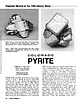
| (above). Pyrite, Alice Glory Hole, Clear Creek County. Cluster of intergrown crystals showing light...Figure 2 (right). Pyrite, Mountain Spring mine, Rico, Dolores County. Cluster of modified cubes; specimen...C*O*L*O*R*A*D*O PYRITE BARBARA L. MUNTYAN Ouray County Museum Ouray, Colorado 81427 Mineral photographs...fine pyrite specimens have been found at Butte, Montana; Park City, Utah; Washington State; and numerous...in significant amounts in virtually all of the mining districts of the Colorado mineral belt. (The Colorado |
 | | Journal (article/letter/editorial) |
| 11 October 2014 A Historical Overview of t h e District and the Smuggler Union and Associated Mines and...history have called Leadville the quintessential mining camp of the frontier. If that is true-and it probably...Telluride was the scene of many encounters that the mining frontier had with its own destiny. From its struggle...here, too, the goals of frontier precious-metal mining shifted in midtwentieth century as the quest for...125 years of mining, are still capable of inspiring wonder at the inventiveness of the mining men and road |
 | | Report (issue) |
| ASSESSMENT OF THE HELENA NATIONAL FOREST, WEST-CENTRAL MONTANA Edited by R.G. Tysdal 1 , Steve Ludington2 , and...ASSESSMENT OF THE HELENA NATIONAL FOREST, WEST-CENTRAL MONTANA U.S. GEOLOGICAL SURVEY OPEN-FILE REPORT 96-683-A...in west-central Montana. It lies in the vicinity of Helena, the capitol city of Montana, and includes Federal...was discovered in the region in Powell County in 1852. Mining began in the 1860's, and since then the...References cited F. Mineral resource geology of mining districts/areas Lincoln Region by R.G. Tysdal, |
 | | Report (issue) |
| Refereaces cited Appendix A - 2 7 Table Table 1. District descriptions Preliminary map of the resource...Range Province. These areas include past or present mining and prospecting activity as well as areas of potential...map are not legal mining district boundaries and may include more than one district as well as adjacent...selected references. The location of each individual mining site was obtained from the U.S. Geological Survey's...this file, the metallic and some no nine tal lie mining sites for the western half of Utah were plotted |
 | | Report (volume) |
| productive parts of the Tintic and East Tintic mining districts JNITED STATES GOVERNMENT PRINTING OFFICE...____ _ ___ ___ ______ ______ ______________ _ Sioux-Ajax fault___________________________________________...productive mines of the Tintic and East Tintic mining districts. It includes the central part of the...source of the ores from the Tintic and East Tintic mining distriets, whose gross production exceeds $428...only their sites remain. Parts of two official mining districts are located within the quadrangle boundaries |
 | | Report (issue) |
| . . . . . . . . . . . . . . . . . 1 Chapter I. Mining Districts of Counties and the State of Utah. .... . . . . . . . . . . . . . . . . . . . . . . 1 County Listings. . . . . . . . . . . . . . . . . . . ... . . . . . . . . . . . . . . . . 1 Chapter II. Mining Districts of Utah . . . . . . . . . . . . . . .... . . . . . . . 4 Mineral Localities Listed by County . . . . . . . . . . . . . . . . . . . . . . . .... . . . . . . . . . . . . . . . . . . 7 Beaver County . . . . . . . . . . . . . . . . . . . . . . . |
 | | Report (issue) |
| indicate annotation of thesis title by addition of county. Capitalization of terms in revised abstracts was...particular to Mis s Edith Rich, and to the Natrona County Library, for procuring theses. Many university...WARD OWEN, 1951, Cambrian diabase flow in [Utah County], central Utah: Brigham Young Univ. M. S. thesis...The Wanship flora correlates with floras of late Montana age of the Mesaverde I Ericson-Almond and lower...the Wanship Formation is of late Niobrara-early Montana age. Near Cameron, Arizona jasper layers occur |


