 | | Report (issue) | | ASSESSMENT OF THE HELENA NATIONAL FOREST, WEST-CENTRAL MONTANA Edited by R.G. Tysdal 1 , Steve Ludington2 , and...ASSESSMENT OF THE HELENA NATIONAL FOREST, WEST-CENTRAL MONTANA U.S. GEOLOGICAL SURVEY OPEN-FILE REPORT 96-683-A...in west-central Montana. It lies in the vicinity of Helena, the capitol city of Montana, and includes Federal...Meagher, Powell, and Lewis and Clark. * Gold was discovered in the region in Powell County in 1852. Mining...Mining began in the 1860's, and since then the Forest has produced gold, silver, copper, lead, zinc, |  | | Report (issue) | | from that in a prior publication wherein the entire MRDS (Mineral Resource Data System) record was published...SierritaEsperanza copper-molybdenum deposit, Pima County, Arizona, in Jenney, J. P., and Hauck, H. R., eds... 1939, Geology of the Lead Mountain area, Pima County, Arizona [M.S. thesis]: Tucson, University of Arizona..., 1920, The southern section of the Amole mining district: Arizona Bureau of Mines Bulletin 106, p. 19-25...(copper and molybdenum), Copper Basin, Yavapai County, Arizona: U.S. Geological Survey Open-File Report |  | | Report (issue) | | .................... THE LUCKY BOY AND PAMLICO MINING DISTRICTS: A COMPARATIVE STUDY by Daniel R. Shawe...Boy mining district ...................................................... Pamlico mining district .....Boy mining district ...................................................... Pamlico mining district .....map of the Lucky Boy mining district 2. Geologic map of the Pamlico mining district ABSTRACT Mineral...veins (for example, Risue Canyon and Meadow Lake mining districts). This metallogenic evolution is consistent |  | | Report (issue) | | Volume II: Flint Creek-South Mountain Area, Owyhee County, Idaho Earl H. Bennett, John Kauffman, and Victoria...Volume II: Flint Creek-South Mountain Area, Owyhee County, Idaho Earl H. Bennett, John Kauffman, and Victoria... . . . . . . . . . . . . . . . 38 3.47 MARTIN PROSPECT (Site No. JV-21). . . . . . . . . . . . . . ..... . . . . . . . . . . . . . . . . 42 3.48 UNNAMED PROSPECT (Site No. JV-16).. . . . . . . . . . . . ... . . . . . . . . . . . . . . . . 108 3.60 UNNAMED PROSPECT (Site No. B7229901). . . . . . . . . . . |  | | Report (issue) | | San Isabel and White River National Forests Lake County Land Exchange Offer (Iocmin40) ......................... 47 White River National Forest Dillon District Land Exchange Joint Venture (Iocmin38) .........prospects and locations of Parcels A-D. Mine and prospect locations from USGS (1998a,b) ..................National Forests Lake County Land Exchange Offer 1. Exhibit A: Property that Lake County will consider exchanging...National Forest Dillon District Land Exchange Joint Venture 1. List of Summit County Tax Default Lands (for |  | | Report (issue) | | National Forest: Volume I: Atlanta Area, Elmore County, Idaho John Kauffman Ted Erdman Earl H. Bennett...National Forest: Volume I: Atlanta Area, Elmore County, Idaho John Kauffman Ted Erdman Earl H. Bennett... .... . .. . ... . 11 2.0 ATLANTA AREA, ELMORE COUNTY, IDAHO ............ .................. 13 2.1 INTRODUCTION...Atlanta Mining Area ... ............ . .. 22 2. 3. 1. 2 Recent History of the Atlanta Mining Area . ....... .... .. 27 3.0 ATLANTAMINING AREA, ELMORE COUNTY, IDAHO-MINE DESCRIPTIONS ..................... |  | | Report (issue) | | in the Challis Area: Challis Area Group, Custer County, Idaho Virginia S. Gillerman Forrest S. Griggs...in the Challis Area: Challis Area Group, Custer County, Idaho Virginia S. Gillerman Forrest S. Griggs...Location map of the Challis Area mine sites, Custer County, Idaho. . . . . . . . . 6 HAZARD ASSESSMENT . ... . . . 7 SITE ID-0458-00001: CARROTHERS/HINES PROSPECT (CH-1099) . . . . . . . . . . . 10 SITE ID-0458-00002:... . . . . . . . . . 10 SITE ID-0458-00003: UNNAMED PROSPECT ( FILE R 071615a) . . . . . . . . . . . . |  | Kelson, C. R., Crowe, D. E., Stein, H. J. (2008) Geochemical and Geochronological Constraints on Mineralization within the Hilltop, Lewis, and Bullion Mining Districts, Battle Mountain-Eureka Trend, Nevada. Economic Geology, 103 (7) 1483-1506 doi:10.2113/gsecongeo.103.7.1483 | Journal (article/letter/editorial) | | Mineralization within the Hilltop, Lewis, and Bullion Mining Districts, Battle Mountain-Eureka Trend, Nevada...and Bullion mining districts, located within the northern Shoshone Range, Lander County, Nevada, are...(e.g., 38.3 ± 0.1 Ma: Gray Eagle mine, Bullion district) and nearby intrusive rocks (e.g., 39.0 ± 0.1...mineralization within the Hilltop, Lewis, and Bullion mining districts. Introduction THE Battle Mountain-Eureka...of 10 mining districts, three of which are located in the northern Shoshone Range in Lander County (Hilltop |  | | Report (issue) | | Idaho: Volume III: Miscellaneous Properties, Owyhee County, Idaho Earl H. Bennett, John Kauffman, and Victoria...Idaho: Volume III: Miscellaneous Properties, Owyhee County, Idaho Earl H. Bennett, John Kauffman, and Victoria... . . . 11 2.0 MISCELLANEOUS PROPERTIES, OWYHEE COUNTY, IDAHO . . . . . . . . . . . . . . . . . 12 2.1.... . . . . . . . 12 2.1.1 Summary of the Owyhee County Study Area . . . . . . . . . . . . . . . . . ..... . . . . . . . . 21 2.5 SUMMARY OF THE OWYHEE COUNTY STUDY AREA . . . . . . . . . . . . . . . . . 24 |  | | Report (issue) | | published information, field investigations, and mining company data. 2 ABBREVIATIONS USED IN THIS REPORT...resources Mining districts Gibbonsville Mining District Indian Creek Mining District Mineral Hill Mining District...Mackinaw Mining District Blackbird Mining District Wilson Creek Mining District Yellowjacket Mining District...Range Mining District Eureka Mining District Carmen Creek Mining District Eldorado Mining District Pratt...Creek Mining District McDevitt Mining District Junction Mining District Texas Mining District Spring |  | | Report (issue) | | Gavilanes Tungsten District El Antimonio District Magdalena District Cananea District Preliminary Deposit-Type...variation in detail. Explanation of Data Fields MRDS RECORD NUMBER Unique number assigned to each record...or to a group of closely-spaced deposits. Two district records have been included (MX00018 and MX02161)...description. Same as the last 4 digits of the MRDS number. IMEX-MRDS was created by Don Huber (USGS) as a modification...or names of individual orebodies. DISTRICT/AREA Informal district name used in the literature. Names |  | | Report (issue) | | in Part A, the name, U.S. Bureau of Mines mining district, reference (if any) that has the occurrence... ILIAMNA QUADRANGLE (Augustine I.) Pumice Redoubt district Iliamna (22.9, 6.4) 59°20'N, 153°27'W Volcanic...not encouraging. (Chenik Mtn.) Iron Redoubt district MF-364, loc. 22 Iliamna (15.6, 4.4) 59°15'N,...low grade. Copper King Copper, Iron Redoubt district MF-364, loc. 7 Iliamna (20.8, 12.15) 59°41'N...Prospective ore said to be rich, but in small bodies. Prospect located in 1905, but has been inactive for many |  | Theodore, Ted G., Blair, Will N., Nash, J. Thomas, McKee, E.H., Antweiler, J.C., Campbell, W.L. (1987) Geology and gold mineralization of the Gold Basin-Lost Basin mining districts, Mohave County, Arizona, with a section on K-Ar chronology of mineralization and igneous activity, and a section on implications of the compositions of lode and placer gold. Professional Paper 1361. US Geological Survey doi:10.3133/pp1361 | Report (issue) | | Mineralization of the Gold Basin-Lost Basin Mining Districts, Mohave County, Arizona U.S. GEOLOGICAL SURVEY PROFESSIONAL...MINERALIZATION OF THE GOLD BASIN-LOST BASIN MINING DISTRICTS, MOHAVE COUNTY, ARIZONA Placer gold nugget about...Lost Basin mining district. Geology and Gold Mineralization of the Gold Basin-Lost Basin Mining Districts...Districts, Mohave County, Arizona By TED G. THEODORE, WILL N. BLAIR, and J. THOMAS NASH With a section on...mineralization of the Gold Basin-Lost Basin mining districts, Mohave County, Arizona. (U.S. Geological Survey Professional | 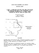 | | Report (issue) | | GEOLOGICAL SURVEY GS MRDS - A SYSTEM BASED ON THE DATA FIELDS USED IN THE NATIONAL MRDS SYSTEM BUT USING...Records, and Fields File structure for data bases MRDS 3' REFER , 4 MRDSGEO 4 Data - a record and its pieces...18 RETRIEVE BY DEPOSIT TYPE CODE 19 EXIT FROM GS MRDS TO DBASE COMMAND LEVEL 19 dot prompt 20 Reporting...digitized latitude/longitude data with the MRDS database Plotting GS MRDS data 30 Making plot files using dBASE...plots 35 Lines and symbols 38 Output to the national MRDS (ne CRIB) system 39 Good conduct medal 39 Examples |  | | Report (issue) | | Geological Survey. Al (Albion Gulch) (Cr.) Gold Council district MF-417, loc. 81 Bendeleben (9.55...stream. At least one "hillside placer." Intermittent mining from 1907 to 1936; dredge operated 1924-27. (American...(American Cr.) Gold, Tin Fairhaven district MF-417, loc. 73 Bendeleben (13.3, 14.9) 65°50'N, 163°08'W...cassiterite has been found. (Anderson Gulch) Gold Kougarok district MF-417, loc. 38 Bendeleben (1.6, 7... Gravels (Andesite Cr.) Diatomite Kougarok district Bendeleben (7.2-7.9, 9.9-10.3) $4°24 f -64°35 |  | | Report (volume) | | of the Southern Inyo Wilderness Study Area, Inyo County, California U.S. GEOLOGICAL SURVEY BULLETIN 1705-B...of the Southern Inyo Wilderness Study Area, Inyo County, California By JAMES E. CONRAD, JAMES E. KILBURN...of the Southern Inyo Wilderness Study Area, Inyo County, California. U.S. Geological Survey Bulletin 1705-B...Southern Inyo Wilderness Study Area (CA010-056), Inyo County, California. CONTENTS Summary Bl Abstract 1...to the Southern Inyo Wilderness Study Area, Inyo County, California PLATE In pocket 1. Mineral resource |  | | Report (issue) | | ..................................... Rudkins prospect - 00006............................................................................. Pinafore prospect - 00008............................................ Pentland prospect - 00021.......................................... Upshot prospect - 00022............................................. Carbine prospect - 00023...................................................................... Bell Ranch gold prospect - 00025................................... Binghampton |  | | Report (issue) | | commodities present (listed alphabetically); the mining district (Ransome and Kerns, 1954 (IC 7679)) in which...named geographic feature, it is titled "Unnamed prospect" or "Unnamed occurrence" and appears ac the end of...•104•01o4Nai .... ....". (Amy Cr.) Copper Chistochina district MF-77313, loc. 163 McCarthy (1.25-1.35, 12.3-12... loc. 10 5 (Barnard Glacier) Iron Nizina district MF-7738, loc. 28 McCarthy (19.1, 2.7) 61°08'N... p. 30, loc. 8 Bear Paw Copper(?) Nizina district McCarthy (12.5, 6.85) approx. 61°23'N, 142°31'W |  | | Report (issue) | | 31 University of Nevada Press, Reno, Nevada 89557 USA Copyright © 2004 by University of Nevada Press Photographs...copyright © 2004 unless otherwise noted Map of Mining Districts and significant mineral occurrences of...6-cm cluster, Majuba Hill Mine, Antelope district, Pershing County. N. Prenn collection. Photograph by J...production of environmental protection equipment. Mining and the discovery, identification, and development...to Nevada in 1929 and was actively involved in mining in the state and the western U.S. for the rest | | | Report (issue) | | Land Stewardship—Headwaters Province, Idaho and Montana Circular 1305 U.S. Department of the Interior...Land Stewardship—Headwaters Province, Idaho and Montana By U.S. Geological Survey Headwaters Province...land stewardship—Headwaters province, Idaho and Montana: U.S. Geological Survey Circular 1305, 92 p. Cover.... Geochronology and Geochemistry of the Idaho-Montana Porphyry Belt, by Cliff D. Taylor, Jeffrey A. Winick...Mineralization in the Boulder Batholith Region, Montana, by Karen Lund, John N. Aleinikoff, Michael J. |  | | Report (issue) | | INTERIOR GEOLOGICAL SURVEY MINERAL RESOURCES OF ELKO COUNTY, NEVADA By Roscoe M. Smith Prepared in cooperation...Acknowledgment -Mining districts Commodities Production Descriptions of mining districts . Alder district-Aura district...district -Beaver district Black Mountain district Bootstrap district Burner district Burns Basin district--...-Carlin district Cave Creek district ----Charleston district_--Coal Mine district~ Contact district Cornucopia...Cornucopia district - -Corral Creek district - Decoy district Delano district Delker districtDivide district |  | | Journal (article/letter/editorial) | | Mountains (Marion and Amethyst prospects and an unnamed prospect) are depleted in Zn and enriched in Mg and...(Salotti 1965, Spry & Scott 1986a) and an unnamed base-metal prospect near Round Mountain (Spry & Scott 1986a)...Mountain and Cotopaxi deposits and the Grape Creek district near Canyon City and noted the intimate association...deposit, 9: Marion deposit, 10: Amethyst prospect, 11: Unnamed prospect, 12: Evergreen zone of hydrothermal...pyrite, pyrrhotite, chalcopyrite, sphalerite, and galena, with subordinate amounts of zincian spinel, magnetite |  | | Report (issue) | | mineral resources-Ari;r:ono__.,...MRDS (Information retrieval system). I. Geological Survey...-------------------------Purpose of the Arizona MRDS records ---------------------------------Complementary...of Arizona showing physiographic provinces and county boundaries --------------------------------------2-23...location of deposits and occurrences listed in Arizona MRDS records as containing: 2. Copper --------------...28 TABLE Page Table 1. Two examples of Arizona MRDS records ----------------------- III 29 Arizona | | | Report (issue) | | 3i University of Nevada Press, Reno, Nevada 89557 USA Copyright© 2004 by Uni versity of Nevada Press Photographs...6-cm cluster, Majuba Hill Mine, Antelope district, Pershing County. N. Prenn coJlection. Photograph by J...percent of the state. Nevada's public lands offer mining, livestock grazing, wild horse viewing, .scenic...Road and Geologic Tours in th<' Las Vegas Area. Mining and the discovery, identification, and development...Vavis The Goodsprings (Yellow Pine) Mining District, Clark County John C. Kepper MINERAL CATALOG 91 |  | | Report (volume) | | __________----_______-______-_--_------.__-__ History of mining and production__.._______.______.___.__-___-_____...claims....___________________________ Steelville prospect,._______________________________________ Spor..._____________________________________ Garfield County..______________________________________ Fullmer...claim__-___._____________-_.____-__-_---___-_Taylor prospect.----_-__--_______________.__-___--__-____Modena...locality.:_________________________________________ Unnamed prospect________ ______.________._.___.._._.____ |
|


