 | | Book |
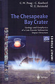
| and deep coring revealed a huge crater, 85 kilometers in diameter and more than a kilometer deep, stretching...Hampton, and Newport News, are located on the western rim of the crater, and still experience residual effects...discoveries. Initial clues to its presence came from deep-sea cores collected by scientists aboard the drillship...Challenger, during a coring cruise off the coast of Atlantic City, New Jersey, in 1983. Diagnostic evidence...revealed that the Chesapeake Bay structure is a complex, peakring/central-peak structure, with many features |
 | | Book |
| Lava fountains near Aloi Crater, on the east rift zone of Kilauea volcano, in May 1969. Photo by U.S. Department...Stream Erosion 161 Mass Transfer 185 Work of the Ocean 195 Sedimentary Rocks 219 Work of the Wind 225 Work...of the Hawaiian Islands and other islands of the mid-Pacific have beckoned the traveler and charmed the...Introduction ACROSS THE FACE OF THE CENTRAL PACIFIC OCEAN, 2,000 miles from the nearest continent and 500...of a great mountain rising from the floor of the ocean. The islands in the northwestern part of the |
 | | Journal (article/letter/editorial) |
| B and G11B signatures in the shallow subduction zone forearc: Examples from Barbados, Costa Rica and...USA – (dsaffer@geosc.psu.edu) 2 Research Center Ocean Margins, Univ. Bremen, P.O.Box 330440, 28334 Bremen...boreholes and mud volcanoes indicate a contribution from deep sources. These observations include pore water freshening...one critical step toward characterizing subduction zone fluid transport. Here, we present a simple model...mudstones in subduction zones. In a generic subduction zone with a taper angle of 8º, we evaluate two end-member |
 | | Report (issue) |
| investigations_ Marine and coastal geology ------------------Atlantic continental margin --------------Shelf geophysical...Estuarine and co·astal hydrology --------------Atlantic coast ---------------------------Gulf coast -...________________ Department of Defense DSDP _____________ Deep Sea Drilling Project dyn _______ ------- _____ -----...joule JOIDES ____ Joint Oceanographic Institutions Deep Earth Sampling JTU ________________ Jackson turbidity...side-looking airborne radar SMOW __________ standard mean ocean water TAPS _________ trans-Alaska pipeline system |
 | | Report (volume) |
| 4. Ground tilting at seismograph stations on the rim of Kilauea caldera during 1952____________________________________...more than 4,000 earthquakes originated beneath the ocean a few miles south of the island of Hawaii. Their...earthquakes commenced at foci along the east rift zone and beneath the caldera region of Kilauea volcano...fountain more than 800 feet high overtopped the rim of the crater at the beginning of the eruption. Gradually...part of the fissure. By 04h on June 28 only the northeastern quarter of the fissure was active, but at about |
 | | Report (chapter) |
| radiogenic lead in five meteorites with those in deep sea sediments and calculated that the Earth formed...in Wyoming, Greenland, western Australia and northeastern China. In the absence of older crustal rocks...plagioclase and Ca-poor pyroxene; diogenites are more deep-seated, plutonic rocks consisting almost entirely...eucrites, but the floors of at least two broad, deep craters reflect that of the deeperseated diogenites...is occupied by a huge basin 460 km wide and 12 km deep. Some collisional fragments undoubtedly were lost |
 | | Report (issue) |
| widely. Domes and flows were erupted in the northeastern third of the eastern source area between 21...tend to be localized above the buried ring-fracture zone of the caldera. Neither the Mount Belknap nor...from these and associated centers constitute the complex accumulation of rhyolite ash-flow tuffs, lava flows...sheet is more than 25 km northeast of the caldera rim. Other major remnants are southeast of Marysvale...facies of the Mount Belknap Volcanics consists of a complex sequence of units derived from both the eastern |
 | | Report (issue) |
| Society of America Memoir 80 STILLWATER IGNEOUS COMPLEX, MONTANA A QUANTITATIVE MINERALOGICAL STUDY H...Edward Sampson began the study of the Stillwater complex, Montana, in 1930. The writer commenced a detailed...detailed study of the mineralogy of the complex in 1935 after several periods in the field in preceding years...Peoples would write the general geology of the complex, Howland the floor rocks and sulfide deposits,...have published a number of short papers on the complex. (Peoples, 1933; 1936; Howland, Peoples, and Sampson |
 | | Journal (article/letter/editorial) |
| and TiO, content is 0.39 wt%. Plagioclase is anorthite (A%-9z). Chromite is characterized by Cr/(Cr +...matter, but their relationships remain still very complex. References: [l]Flynn G.J. (1989)Icams, 77, 287-310...the degree of melting was insufficient for magma ocean development, thereby avoiding global isotopic homogenization...approximately 2 . 5 as chondrites [l]. All other factors (fracture density, exposure history, initial mass, etc.)...[2-41 as well as in a piece of KfT bolide found in ocean sediments [5]. In light of the fact that E chondrites |
 | | Report (volume) |
| widely. Domes and flows were erupted in the northeastern third of the eastern source area 21 m.y. ago...tend to be localized above the buried ring-fracture zone of the caldera. Neither the Mount Belknap nor...from these and associated centers constitute the complex accumulation of rhyolite ash-flow tuffs, lava flows...sheet is more than 25 km northeast of the caldera rim. Other major remnants are southeast of Marysvale...facies of the Mount Belknap Volcanics consists of a complex sequence of units derived from both the eastern |
 | | Journal (article/letter/editorial) |
| the garnets reveal double-stage growth with a complex zoning pattern due to reaction-partitioning during...metapelites along a cross-section through the M n zone and the Higher Himalaya imply distinct readjustments...varying amounts everywhere along the MCT zone. This thrust zone (including the slightly north-northeast...the centre, northeast of the Kishtwar window, a zone with huge gneiss domes with a concordant sedimentary...structures to the north-west and an imbricate thrrrst zone near the Doda valley (Zanskar) can be correlated |
 | | Book (volume) |
| Manganese and Manganiferous Iron Deposits of Northeastern Hokkaido (C04). 1 Yu Hariya, Hiroyuki Miura...MANGANESE AND MANGANIFEROUS IRON DEPOSITS OF NORTHEASTERN HOKKAIDO Yu Hariya15, Hiroyuki Miura!) and...manganese deposits of early Cretaceous age in northeastern Hokkaido, which will be visited during the Post-Conference...were found around "Yunotaki Falls", where an ore zone, approximately 150m x 70m, is distributed. The ini¬... MANGANESE AND MANGANIFEROUS IRON DEPOSITS OF NORTHEASTERN HOKKAIDO 3 Table 2. Chemical composition of |
 | | Report (issue) |
| correlative strata in Montana, western Wyoming, and northeastern Utah, by William J. Sando _________________...Cretaceous strand lines in northwestern Colorado and northeastern Utah, by A. D. Zapp and W. A. Cobban_ 113. Strn...___________________ _ 114. Salt anticlines and deep-seated structures in the Paradox basin, Colorado...141. The Republic graben, a major structure in northeastern VVashington, by Mortimer H. Staatz ____________________...Evidence for two stages of deformation in the western Sierra Nevada metamorphic belt, California, by Lorin D |
 | | Report (issue) |
| appropriated for electrical power production in the mid 1930s. Back: (Top) Lizard Butte near Marsing, an...magmatic, structural, and tectonic evolution of this complex geologic system. We have organized the book into...midpoint of the 1,100-km-long NevadaOregon rift zone. Strontium isotopic variations reflect crustal and...lithosphere variations along the trend of this rift zone, with the basalt area of Oregon and Washington lying...generated by the interaction of a relatively fixed deep thermal plume with a moving lithospheric plate. |
 | | Report (volume) |
| Mexico � 2. Column of preexisting ash in stream-cut ridge northwest of 16 Paricutin � 21 3. Cornfield at Chorotiro...� 7. New barranca eroded into Casita Canicjuata ridge � CONTENTS V Page FIGURE 8. Midslope in Casita...de Canicjuata 61 � 20. Head wall of landslide in deep ash from Paricutin � 61 21. Mudflows between Jaratiro...ash � 73 33. Converging rill heads at crest of ridge south of Paricutin_ _ _ _� 74 34. Parallelogram...outward and the corresponding sections of crater rim to slump. Only one of the cones, Cutzato, has an |
 | | Report (issue) |
| RATTE and THOMAS A. STEVEN ABSTRACT A complex pile of Tertiary volcanic rocks in the central...welded pumice breccia that is confined to the northeastern side of the Creede caldera. The source of the...welded quartz latite tuff, but a partially welded zone is present at the top of the formation, and several...have been identified near the caldera ring fracture zone. The rocks of the Creede caldera sequence show...ash-flow field near Creede surrounds a cauldron complex at least 25 miles long and 5-15 miles wide that |
 | Dill, H. G., Skoda, R., Weber, B., Berner, Z. A., Muller, A., Bakker, R. J. (2012) A Newly Discovered Swarm of Shear-Zone-Hosted Bi-As-Fe-Mg-P-Rich Aplites and Pegmatites in the Hagendorf-Pleystein Pegmatite Province, Southeastern Germany: A Step Closer to the Metamorphic Root of Pegmatites. The Canadian Mineralogist, 50 (4) 943-974 doi:10.3749/canmin.50.4.943 | Journal (article/letter/editorial) |
| 3749/canmin.50.4.943 A NEWLY DISCOVERED SWARM OF SHEAR-ZONE-HOSTED Bi–As–Fe–Mg–P-RICH APLITES AND PEGMATITES...deepest parts of the pegmatite, close to its root zone, and on the other, within the uppermost parts of...pegmatites (i.e., not exposed). Keywords: shear zone, pegmatite–aplite swarm, phosphate, sulfide, arsenide...sandwich-like within metamorphic country-rocks along a shear zone, addresses four pivotal questions. 1. How is the...pegmatite province, embarking on a comparison with shear-zone related mineralization in general at the western |
 | | Book |
| . . . . 1.2 Northern Grauwackenzone (Greywacke Zone), Land Salzburg 1.3 Hohe Tauern, Land Salzburg ... . . . . . . . . . 4.1.1 Ilimaussaq Intrusive Complex, Kvanefjeld . . 4.1.2 Puissagtaq Area, Igaliko.... . . . . . . . 6.4.1 Saint-Hippolyte Area, Northeastern Vosges, Dpt. Haut-Rhin . . . . . . 6.4.2 Pegmatitic...Sedimentary Basins in Saxony . . . . 7.3.1 Elbtal Zone. . . . . . . . . . . . . . . . 7.4 Northwest Saxony...West Carpathians . . . . . . 14.1.1 North Gemer Zone . . . . . . . . . . . . . . . . . . . . 14.1.2 Central |
 | | Journal (volume) |
| A. 1., Morozov S. A. The Kammenoozero structural zone . . ...... . .. . . . ....... ... ..... ... The...of the granite gneiss complex of eastern Finland .. ... . The granulite complex and associated formations..... Layered intrusions in the Archean basement complex ............... ... Nickel deposits associated............... . ... ... . . ... . ... . . . .... Deep structures as revealed on lhe gravimetric map .... ......... .. .............. . The ultramafic complex .. ................... .. .... . ........ . . |
 | | Report (issue) |
| collected at Shorty Crater. (3) Orange soil on the rim of Shorty Crater with the gnomon in the background...coverage, and its glorious splashdown in the Pacific Ocean surely marked Apollo 17 as the mission most impressively...detailed analysis of the Apollo 15 imagery. The rim of the Serenitatis basin in the Taurus-Littrow region...billion years ago or earlier. In comparison, the ocean basins of the Earth are younger than 300 million...to place num concentrations constraints on the deep lunar interior temperatures, the terra or highland |
 | | Journal (article/letter/editorial) |
| melt was formed by shock fusion of a basement complex, consisting of about 80% biotite granite and 20%...multi-colored breccia is exposed, the chilled bottom zone is about f m thick. The boundary between vitreous...microscopic size are equally vitreous in the chilled zone and devitrified in the interior of the mass. In...layers have survived erosion even the upper chilled zone has been observed (Zipplingen, Otting). The thickness...orthoelase contents with a rather high admixture of anorthite (Fig. 3). Source material of these glasses are |
 | | Book |
| Tides 9.8.1. Lunar Orbit 9.8.2. Body Tides Ocean Tides Research Stations on the Moon 9.9.1. Weighing...Crust and Ocean 15.3.2. Impact Craters 15.3.3. Chaotic Terrains 15.3.4. Life in the Ocean 15.3.5. Summary...353 354 356 356 17. Titan: An Ancient World in Deep Freeze A: Physical and Orbital Properties Atmosphere...radiate into interstellar space. We simplify this complex subject by emphasizing the main events in the evolution...sighted land after sailing west across the Atlantic Ocean six years before Vasco da Gama reached India |
 | | Report (volume) |
| plateau of British Columbia, as seen from Bauernian Ridge, Okanogan Mountains, Washington; B, Rugged topography...from a peak about 8,000 feet iu height on Bauerman Ridge. This feature is noticeable for essentially the...prominently developed, the range is apparently a complex one and should be subdivided. This was recognized...nearly every ridge and mountain in the range. As a rule, the south slope of every spur or ridge is regular...of from 1,400 to 1,700 feet, and isolated by the deep 16 CASCADE RANGE NEAR FORTY-NINTH PARALLEL. |
 | | Journal (issue) |
| gem-quality zincite crystals, displaying a magnificent deep red colour have been cut. One example weighing 20...closest to the diaphragm display small needles of complex morphology (Figure 3a). The more distant zones...(reductive environment) Secondary zincite crystals form complex groups, commonly on relict primary zincites, and...with diverse pyramidal terminations (Figure 7). Complex pyramidal crystals showing pronounced hemimorphism...brown. Their colour intensity varies from pale to deep and saturated. Colour distribution in the larger |
 | Stark, J. T., Johnson, J. H., Behre, C. H. Jr., Powers, W. E., Howland, A. L., Gould, Don B. (1949, January) Geology and Origin of South Park, Colorado. GSA Memoir 33. Geological Society of America doi:10.1130/mem33 | Report (issue) |
| ... . . .......... . ...... . .... . 95 Basin Ridge group ... ... .. ... ... ... . ............... ...... ....... . . . . . ... . . . .. . . . Basin Ridge syncline .. . . . .. ...... ... . ... . . . . ......... . .. . .. . . . ... . .. . ... . Mexican Ridge anticline ............. . ............ . . . . ... . . . . . . . . . . . . . . . . . . . . Basin Ridge volcanic rocks. . .. . . . . . . . . . . . . . ...boulders on surface and in loose soil of Mexican Ridge. . . . . . . . . . . . . . . . . . . . . . . 117 |


