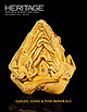
 | | Catalog/List |
| including the largest Gold nugget ever found in Alaska AND the world’s largest single Gold crystal – all...• • • • The largest Gold nugget ever found in Alaska, known as The Centennial Nugget, weighing 20 pounds...of Crystallized Gold from the famed Eagle’s Nest Mine in California A superb Crystallized “Leaf” Gold...gemstone Amethyst to come from the famed Four Peaks Mine in Arizona A sharp and complicated Crystallized...the famed Wolverine Mine in Michigan A “classic” Rhodochrosite with associated Pyrite and Quartz from the |
 | | Report (issue) |
| INTRODUCTION. The area here called the Cosna-Nowitna region extends southward from Yukon and Tanana rivers...general way the 1 Hcrron, J. S., Explorations in Alaska, 1899: War Dept., Adjt. General's Office, No. 31... 1901. 211 212 MINERAL RESOURCES OF ALASKA, 1915. Yukon-Kuskokwim divide. A pack train of seven...the Yukon and Kuskokwim were mapped. Geologic mapping was extended over practically the same area. The...the eastern part. Still farther east, beyond the area surveyed, several small isolated ranges and hills |
 | | Report (volume) |
| GOLD-PLACER DISTRICT ALASKA WITH ACCOUNTS OF THE CENTRAL KUSKOKWIM YALLEY AND THE RUBY CREEK AND GOLD HILL................................................. Innoko Valley......................................................................................... Yukon River....................................................................... Mail service to the Innoko............................................. Effect.......................... Geologic sketch of the Innoko-Kuskokwim region............................ Introduction |
 | | Report (volume) |
| Director Bulletin 754 THE RUBY-KUSKOKWIM REGION ALASKA BY J. B. MERTIE, JR. ' AND G. L. HARRINGTON...Local details____ ___________ Yukon River______ _________ Poorman Creek _____ Nowitna and Susulatna valleys...rocks Continued. Local details Continued. Page. Innoko district__________________________ 30 Takotna and...fish____ _ Other mining factors __________________________ Gold placers _ _ _ Ruby district _______________________________..._______________________________ History of mining ______________________ General character of placers________________ |
 | | Report (issue) |
| RUBY-KUSKOKWIM REGION ALASKA BY J. B. MERTIE, Jr. Mineral resources of Alaska, 1933 (Pages 115-245)...________-___ Ruby district._______-___-____--._-_--.-__---_--__._______ Ruby area.______-_____--_---...area____-______.__--_-___--__-_-___-_________ 145 Long Creek and Bear Gulch..____________________ Fifth of July...______________________ Greenstone Creek.._______._________._._-_._.___._ Monument Creek.______________________________...Meketchum Creek._______________________________ Trail Creek____.________________________ Flint Creek and tributaries |
 | | Report (volume) |
| Brooks.................................... 5 The mining industry in 1908, by Alfred H. Brooks............peat fuel in Alaska, by C. A. Davis . . . . . . . . . . . . . . . . . . . . . . 63 Mining in southeastern...southeastern Alaska, by C. ,V. Wright............................. 67 Copper mining and prospecting on Prince...resources of southwestern Alaska, by W. W. Atwood.................. 108 Mining in the· Kotsina, Chitina...Chitina, Chistochina, and Valdez Creek regions, by F. H. l\1offit......................................... |
 | | Report (issue) |
| region led to the mapping of the most productive area by the Geological Survey in the field season of...special map. The area covered by this map lies in about the central part of Alaska. It is about 35 miles...party that was engaged in studying the geology and mining developments. The results of this work will be...accompanying geologic sketch map (PI. VIII), including the area covered by the Fairbanks special map, has been prepared...GEOGRAPHIC SKETCH. RELIEF. The surface of this area is predominantly one of ridges alternating with |
 | | Report (volume) |
| SMITH, DIRECTOR 578 THE ^ IDITAROD-RUBY REGION ALASKA BY HENRY M. EAKIN WASHINGTON GOVERNMENT PRINTING...................... Other conditions affecting mining............... .«........................ General... Iditarod district........................................................ Innoko district..................................................... Ruby district..................................................................................... Iditarod district.............................................. |
 | | Report (issue) |
| GOLD PLACER MINING DEVELOPMENTS IN THE INNOKO-IDITAROD REGION. By A. G. MADDREN. INTRODUCTION. Although...of the pioneer American prospectors of interior Alaska are known to have entered and passed through parts...as 1889, and others are said to have visited the Innoko Valley as early as 1898, placer gold in paying...this part of Alaska until 1906. In the summer of that year gold was found on Ganes Creek, one of the principal...principal headwaters of Innoko River, and since then a placer camp, with an average population of 150 |
 | | Journal (article/letter/editorial) |
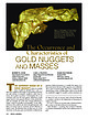
| Fairbanks mining region, Alaska, USA. Donated in 1977 by Arthur Sexaur. University of Alaska Museum of...approximately 89 troy ounces, Ganes Creek, Iditarod district, Yukon-Koyukuk Borough, Alaska. This nugget shows extreme...United States Alaska, Bear Creek near Hope Alaska, Brooks Range Alaska, Caribou Creek near Kantishna...98 ounces Alaska, Fairbanks, Gilmore Creek 1912 nugget 24.8 ounces Alaska, Ganes Creek 1985 nugget...nugget Alaska, Ganes Creek 2004 mass with quartz Alaska, Ganes Creek 1985 Alaska, Ganes Creek Maslowski |
 | | Report (volume) |
| Synopsis of the Mineral Resources and Geology of Alaska GEOLOGICAL 1 SURVEY BULLETIN 1307 Synopsis... Synopsis of the Mineral Resources and Geology of Alaska By EDWARD H. COBB GEOLOGICAL SURVEY BULLETIN 1307...with the Department of Natural Resources, State of Alaska UNITED STATES GOVERNMENT PRINTING OFFICE, WASHINGTON:...Introduction _________________________________ Alaska Peninsula region ___________________________ Aleutian..._________ Northern Alaska region ____________________________ Northwestern Alaska region _^_______________________ |
 | | Report (volume) |
| Placer Deposits of Alaska By EDWARD H. COBB GEOLOGICAL SURVEY BULLETIN 1374 An inventory of the...the placer mines and prospects of Alaska, their history and geologic setting UNITED STATES GOVERNMENT...and method of presentation __ Definitions _-____ Alaska Peninsula region Aleutian Islands region ________...Anchorage district _ Redoubt district ___-_ _ Valdez Creek district __ _ Willow Creek district Yentna district...district _____________ _ ____ __________ _____ Copper River region __ _ _ _ Chistochina district Nelchina |
 | | Report (issue) |
| Division of Mining & Water Management FRONT COVER Top left: From late 199] to 1993 Cambior Alaska Inc. constructed...Phase one channeled the stream around the open-pit mine operations. During the stream diversion the company...flow, and fish populations. When the mine closed, Valdez Creek was diverted back to its original location...excavation work on Pit A-8 of Valdez Creek gold mine operated by Cambior Alaska Inc. as it appeared in early...early August 1994. From 1984 to 1995 Cambior Alaska and previous operators produced 459,162 ounces (14,279 |
 | | Journal (issue) |
| Lawrence, Kansas Front cover Quartz scepter with pyrite, 7 cm, from Spruce Ridge, King County, Washington;...Acanthite with silver, 2.6 cm, from the Uchucchacua mine, Peru; Allan Young collection and photo. Amethyst...that is, the states of Oregon, Washington, Idaho, Alaska and the Canadian Provinces of British Columbia...to the Yukon, and in 1899 more gold was found around Nome, Alaska, drawing away many of the Yukon prospectors...prospectors. All of this activity gave a jump-start to mining interests and prospecting in the lands of the Pacific |
 | | Report (issue) |
| MINERAL INDUSTRY OF ALASKA IN 1926 By PHILIP S. SMITH* INTRODUCTION Records of what has been done in...The investigations of the imineral resources of Alaska which the Geological Survey has been [carrying...755, 773, 783, and 792. 2 MINERAL RESOURCES OF ALASKA, 1926 generously put at the disposal of the Geological...obtained from other sources. Many of the important Alaska newspapers are courteously sent toj the Geological...year] sends to each person known to be operating a mine or prospect sched-J ules on .which are queries to |
 | | Report (volume) |
| FINENESS OF GOLD FROM ALASKA PLACERS BY PHILIP S. SMITH Mineral resources of Alaska, 1937 (Pages 147-272)...__-_____Metals other than gold in bullion from Alaska placers________ Descriptions of regions in relation...placer gold Southeastern Alaska region__________________________ Juneau district ____________________ Porcupine...Slate Creek area__________________________ Middle Fork area___________________________ Rainy Creek area___...district_________________________________ Nelchimi district ______________________________ Cook Inlet-Snsitna |
 | | Report (volume) |
| separate publication ) (A) Mineral industry of Alaska in 1936, by P. S. Smith (published in March 1938)...--------------------_1 (B) 'The Valdez Creek mining district in 1936, by Ralph Tuck (published in March...publications on Alaska. _ _ _ _ _ On back of plate 1 ILLUSTRATIONS Page PLATE 1. Map of Alaska, showing areas...and maps of Alaska.___________________________ In pocket 2. Sketch map of Fortymile district, showing location...gold placer-mining operations.____--__-__-______-_-__--_---_160 3. Sketch map of Eagle district, showing |
 | | Report (issue) |
| Director °\ Bulletin 880 MINERAL RESOURCES OF ALASKA REPORT ON PROGRESS OF INVESTIGATIONS IN 1935 ...separate publication] Page (A) Mineral industry of Alaska in 1935, by P. S. Smith (published in March 1937)...Capps (published in January 1938). Ill (D) The Eska Creek coal deposits, Matanuska Valley, by Ralph Tuck (published...publications on Alaska..___0n back of plate 1 ILLUSTRATIONS Page PLATB 1. Map of Alaska, showing areas...covered by selected available reports and maps of Alaska.._-______----___________ In pocket 2. Reconnaissance |
 | | Report (issue) |
| developed, the deposit will be mined by underground mining methods. The deposit is part of lands owned by...placer gold mine operations on the Eureka and Mary's bench depositsin the Koyukuk-Nolan district of northern...northern Alaska. The center nugget weighs 41.35 ounces (1,286 grams) and is unofficially the tenth largest...by Tom Bundtzen) Top right: The Valdez Creek placer gold mine, 50 miles (80 kilometers) east of Cantwell...Cantwell, has been Alaska's largest gold mine for ten of the last eleven years, and it is one of the largest |
 | | Report (issue) |
| MINERAL RESOURCES OF ALASKA, 1913. By ALFRED H. BROOKS and others. PREFACE. By ALFRED H. BROOKS The...annual bulletins 1 treating of the progress of mining in Alaska a.nd summarizing the results achieved du.ring...particular district are therefore urged to procure a. copy of the com plete report on th.at district as soon...the year and summaries of the conditions of the mining industry, including statistics of mineral production...shall serve as convenient reference works on the mining industry for the yea.rs which they cover. Lack |
 | | Report (volume) |
| SMITH, Director Bulletin 649 ANTIMONY DEPOSITS OF ALASKA BY ALFRED H. BROOKS WASHINGTON GOVERNMENT PRINTING................................................. Mining developments and production........................................ 1............... Fairbanks district. ................................................................................... Fredericks mine.......................................... Spaulding............ Eldorado Creek Mining Co ................................ Newsboy mine.................... |
 | | Report (issue) |
| of the Kobuk River basin there is a mineralized area in which placer gold has been mined and copper,...produced annually for several years, in 1910 the district was nearly deserted. Many problems of importance...and the Kobuk on the south. Although this small area is the place where minerals of economic importance...features of northwestern Alaska is in preparation and will serve to extend the area covered by this more...TOPOGRAPHY. Figure 19 shows the general location of the area, which for convenience will be called the Shungnak |
 | | Report (issue) |
| prospects, and mineral occurrences throughout Alaska. ID018 ID020 ID026 ID027 ID028 013 ID035 ID032...in the Iditarod 1:250,000 quadrangle, southwest Alaska This and related reports are accessible through...S. Government. OPEN-FILE-REPORT 96-540 site District Mt. Joaquin McGrath Site type Prospect ARDFno...Miller, M.L USGS 5/25/94 site District Yankee Creek Innoko Site type Mine ARDFno. ID002 Quad-250 ... Location 156.39440 AK USGS MF-363, Loc. 44. Mine and tailings marked or Iditarod (D-1) topographic |
 | | Report (issue) |
| MINERAL RESOURCES OF ALASKA, 1915. By ALFRED H. BROOKS and others. PREFACE. By ALFRED H. BROOKS. This...of annual bulletins * treating of the mining industry of Alaska and summarizing the results achieved during...particular district are thereforeurged to procure a copy of the complete report on that district as soon...the year and summaries of the condition of the mining industry, including statistics of mineral production...the mining industry for the years which they cover. Lack of funds prevents a visit to every mining district |
 | | Report (issue) |
| Development Division of Mining & Water Management FRONT COVER Top: Ryan Lode Mine gold recovery plant and...investigates a silver prospect in the Chulitna mining district during a DGGS mapping project in July 1997...(left) and Jim Vohden (right) of the Alaska Division of Mining & Water Management, and Bronwen Wang of...zone on face in the Greens Creek Mine on Admiralty Island west of Juneau, Alaska. Photo by Jan Nauman. GEOLOGY...ip nw si 9" K.H. Clautice + ee J.L. Nauman Alaska Department of Natural Resources Division of Geological |


