 | | Report (issue) |
| GEOLOGY OF THE GEORGETOWN QlJADRANGLE (TOGETHER 'VITH THE EMPIRE DISTRICT) COLORADo· BY JOSIAH E. SPURR............... Topography and geography of the Georgetown quadrangle ...................................................._.......... . Distribution in Colorado ...................................................................... . Distribution in the Georgetown quadrangle ......................................... : ............ _.... 97 Gold belt near Georgetown.· .................. _. __ ........... , .. _ |
 | | Journal (issue) |
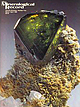
| 602-297-6709 Articles The Iron Cap mine, Graham County, A rizona.................................81 by...Ouray County, Colorado ............... 89 by B. & J. Muntyan Anatase on quartz from Ouray County, Colorado...7413 N. AZ Mowry Place Tucson, 85741 COVER: SPHALERITE crystal, 1.8 cm, on jo h an n sen ite from the...in Arizona (the Iron Cap mine) and in Ouray County, Colorado, are described in three articles, and a great...huge i show organized by Herb Duke at the Pima County Fairgrounds. Following the advertising section |
 | | Report (issue) |
| - - - -Post-Wasatch erosion and deformation (Snowdrift cycle) ______________ - -Tygee erosion surface...-Homer and Long Valleys ______________ _ Willow Creek Basin Ridges ______ - - _- - -Pine Mountain and...________________ _ Dry Ridge ___________________ _ ~ Snowdrift Mountain _____ - - - - - -Preuss Range proper...Soda Springs Hills ____________________ _ Willow Creek lava field ________________ _ Generalfeatures __________________..._ Water supply _____________________ ._ Meadow Creek extension ___________ _ Portneuf Mountains ___________________ |
 | | Report (issue) |
| Geology and Ore Deposits of the Front Range Colorado By T. S. LO\'ERING and E. N. GODDARD GEOLOGICAL...in cooperation with the Colorado State Geological Survey Board and the Colorado Metal Mining Fund ~ oopr...hornblende gneiss ____________ _ Quartzite at Coal Creek ________________ _ Igneous rocks _____________________________...Quartz diorite and associated hornblendite_ Boulder Creek granite _________________ _ Pikes Peak granite ..._____________________ _ Copper deposits in Jefferson County __ _ F. M.D. property _____________ _ Malachite |
 | | Report (issue) |
| Mendenhall, Director Bulletin 849 D THE MOUNT EIELSON DISTRICT ALASKA BY JOHN C. REED Investigations in Alaska...Base_____________________________________________ Snowdrift-_____________________________________________...Mount Eielson district- _________ In pocket Geologic map of the Mount Eielson district.___________ In...Mount Eielson district..--. In pocket Geologic map of part of the Mount Eielson district._____ In pocket...and Moose Creek), five areas likely to be principally valuable for gold (Fairbanks, Willow Creek, Girdwood |
 | | Report (volume) |
| _________________________________________ North Fork-Shoup district, Idaho___-__. ___________ Garm- Lamoreaux mine______...prospect_______________________________________.____ Snowdrift claim...________________________________ Twilight...claim_________________________________________ Blackbird district, Idaho_._______________________________ Calera...mine__._____________-____-___--________-_ Forney district, Idaho________________________________________..._______________________________________ Birch Creek district, Idaho__-_______._______________________-__ |
 | | Report (issue) |
| GEOLOGICAL SURVEY Locatable Mineral Reports for Colorado, South Dakota, and Wyoming provided to the U.S.............................................. 1 COLORADO ................................................San Isabel and White River National Forests Lake County Land Exchange Offer (Iocmin40) ......................... 47 White River National Forest Dillon District Land Exchange Joint Venture (Iocmin38) ......................... 138 FIGURES OR ATTACHMENTS COLORADO Pike National Forests Shepard and Associates Land |
 | | Book |
| JAMES R. HEIN US Geological Survey Menlo Park, CA, USA 2004 ELSEVIER Amsterdam 9B o s t o n 9H e i d e...and then 'Obtaining Permissions'. In the USA, users may clear permissions and make payments through the...Center, Inc., 222 Rosewood Drive, Danvers, MA 01923, USA; phone: (11)(978)7508400, fax: (11)(978)7504744,...of Idaho, Utah, Montana, Wyoming, Nevada, and Colorado in the northern Rocky Mountains. The thick, high-grade...analysis. His research has been both domestic (Colorado, Wyoming, Nevada) and foreign (China, Pakistan |
 | | Report (issue) |
| _____________________ Dawley Canyon area, Elko County-______--_--_------_-_-_-_-_---_-_ Location and...County__-__________-_-_-_---_-______.__-_-_-_ Corral Creek..________________________________________________...Pass. -__-_--__--_---__--_--_--__------White Pine County.-._____________________________________________...171 172 172 173 nt IV CONTENTS Page Pershing County.-_____________---___-____--___________-__--__---Lakeview...Ridge__---_-___-_--__________-_--_--_____._ Nye County..___________________________________ Bullfrog HiUs |
 | | Book |
| at aks SUMMIT AGold Rush History of Summit County, Coldrado By Mary Ellen Gilliland Copyright 1980...Press Box 499 Silverthome, Colorado 80498 iv For the people of Summit County, past and present, and...Nineteen Summit Map Bibliography Index This Is Summit County Before the Rush Began: The Rocks That Made the... ate “step eae ated Author’s Note An 1881 Colorado mine town newspaper made this editorial jab at...halls and variety theatres.” This history of Summit County during its mineral rush heyday strives for accuracy |
 | | Journal (article/letter/editorial) |
| Soviet studies of ore deposits. to the galena-sphalerite ores, which occur in silicate rocks (basaltoids...and N. Z. Yevzikova. The Kvaysa barite-galena-sphalerite vein de posit is located on the southern slope...northerly-trending, steeply-dipping faults in the district, which control the distribution of the Kvaysa...Varakhkom, Valkhokh, and other barite and galena-sphalerite ore bodies. The range of vertical mineralization...composition: besides the predominant galena and sphalerite, they contain minor calcite, illite, chlorite |
 | | Report (issue) |
| 3i University of Nevada Press, Reno, Nevada 89557 USA Copyright© 2004 by Uni versity of Nevada Press Photographs...6-cm cluster, Majuba Hill Mine, Antelope district, Pershing County. N. Prenn coJlection. Photograph by J...Vavis The Goodsprings (Yellow Pine) Mining District, Clark County John C. Kepper MINERAL CATALOG 91 121...Mountain Mine Grossular, Nightingale district Grossular, Buena Vista district Gypsun1 Heterogen ite He½•eltite...Magnesio-axinite Malachite Malachite and Azurite, Robinson district Malachite after Azurite, Mount Potosi Marcasite |
 | | Journal (issue) |
| only comprehensive mineralogical study of the district. This work is as valuable today as it was 37 years...the northeast. The area is drained by Silver Bow Creek, which flows west into the Warm Springs Ponds where...extraction technology originally conceived in the district were considered the state-of-the-art around the...and dug gravel which they washed in Silver Bow Creek to the south. This gravel yielded Butte’s first...1957). By the winter of 1864 the Summit Valley district (Butte’s original name) had been organized, with |
| | Report (issue) |
| 31 University of Nevada Press, Reno, Nevada 89557 USA Copyright © 2004 by University of Nevada Press Photographs...6-cm cluster, Majuba Hill Mine, Antelope district, Pershing County. N. Prenn collection. Photograph by J... The Goodsprings (Yellow Pine) Mining District, Clark County John C. Kepper 91 References 467 Contributors...Nightingale district Quartz epimorph after Calcite Agardite Grossular, Buena Vista district Quartz (amethyst)...Orpiment inclusions Calcite, Getchell Mine Robinson district inclusions inclusions Realgar and Fluorite Rhodochrosite |
 | | Report (issue) |
| districts and mines ______________________ _ Rimini district ____________________________ _ Lee ·Mountain-V~lley...deposits-Continued Mining districts and mines-Continued Rimini district-Continued Mines in the southern area ______________..._ Other mines _______________________ _ Clancy district ____________________________ _ King Solomon mine...____________ - <- __________________ _ Wickes (or Colorado) district ___ ~------------Al ta mine _____________________________...districts and mines-Continued Wickes (or Colorado) district-Continued David Copperfield adit __________________ |
 | | Journal (article/letter/editorial) |
| only comprehensive mineralogical study of the district. This work is as valuable today as it was 37 years...the northeast. The area is drained by Silver Bow Creek, which flows west into the Warm Springs Ponds where...extraction technology originally conceived in the district were considered the state-of-the-art around the...and dug gravel which they washed in Silver Bow Creek to the south. This gravel yielded Butte’s first...1957). By the winter of 1864 the Summit Valley district (Butte’s original name) had been organized, with |
 | | Journal (issue) |
| 1 could see through it. Several sections were clear as glass, but the rest somewhat milky. The old jewel...ores were abundant around my home, in Crawford county of Eastern Missouri. It had been eleven years since...fact the Flat River District in eastern Missouri is the big~est lead producing district in the world. Joplin...galena with nice pyrite crystals, iridescent sphalerite, marcasite, etc. The principal minerals mined...state are barite, pyrite, limonite, hematite, sphalerite and galena. Some gold has been discovered, and |
 | | Report (volume) |
| Rm G-84 DENVER, Colorado--Federal Bldg., Rm. 169, 1961 Stout St. LAKEWOOD, Colorado-- Federal Center...rock types 133 Cross section through the Kalavos district Cyprus showing relationship of massive sulfide...represents an individual deposit (or, rarely, a district), cumulated in ascending grade or tonnage. Where...lump everything from a single district (and then argue about district boundaries). For the most part...quantitative process models. Many authors prefer to keep a clear distinction between descriptive and genetic models |
 | | Book |
| 193-256 137-208 129-192 209-264 193-256 [ [ COLORADO-Ill] 177-256 121-184 89-168 1-120 1-88 [ ...177-256 185-280 169-248 [ 425-528 337--400 COLORADO-II] 321--400 337--400 ARIZONA-Ill] 337--400...69-132 65-128 1-64 11 / 1980 20 I 1989 [ COLORADO-I] [ 289-352 385-448 [ AUSTRALlA] 353-504...Iaria from the Howard-Montgomery quarry, Howard County, Maryland (by J. S. White) 25:53-54 AFGHANISTAN...Iron-manganese phosphates of the Williams pegmatites, Coosa County, Alabama (by P. B. Leavens & T. A. Simpson) 6:66-73 |
 | | Report (issue) |
| vuggy quartz associated with pyrite, ga l ena, sphalerite , pyrargyrite , native silver, chalco pyrite...associated with galena , chalcopyrite , pyrite , sphalerite, bismuth, argentiferous bismuthinite, silver...variety of metallic m i n e ral s including: sphalerite , ga l ena , pyrite , marcasite , pyrrhotile...on the north facing slope of Galena Hill, Mayo District (R . M . Thompson , 1951 : Am . Mineralogist ...in the Keno Hill - Sourdough Hill area , Mayo District , argentite is associated with native silver and |
 | | Report (issue) |
| ........................................ Apple Creek Formation................................................................................ Lawson Creek Formation.........................................mining district................................................ Basal dolomite of Bayhorse Creek............................... Upper carbonate of Cash Creek...................................................Hobbs.................................... Bayhorse district subterrane................................... |
 | | Book (edition) |
| Chapters on the Coeur d'Alene Mining District, the Blackbird Mining District, and the Sawtooth Mountains by...Chapters on the Coeur d'Alene Mining District and the Blackbird Mining District, and to Ben Sheppard for reviewing...reviewing the chapter on the Blackbird Mining District. Those who contributed photographs, or specimens...problems are with mine names and occasional1y mining district names. Mining districts, generally are not now...the Coeur d'Alene District is the name presently used for the entire silver district that runs from Kellogg |
 | | Report (issue) |
| Al"'EU. 74 GEOLOGY AND ORE DEPOSITS OF THE BUTTE DISTRICT, MONTANA BY \¥ALTER I-IAllVEY vVEED WASHINGTON.................................. Future of the district .................................. ·............CnAP'rER IlL-Descriptive geology of the Butte district ........................ , . . . . . . . . . .... . . . . . . . . . Quartz monzonite of Butte district................................................. \ 4 CONTENTS. Page. IV.-Structure of Butte district .... ; ...................................... |
 | | Report (issue) |
| Paper 172 GOLD QUARTZ VEINS OF THE ALLEGHANY DISTRICT CALIFORNIA BY HENRY G. FERGUSON AND ROGER W...__--__.-_-__-_________ Mines of Oregon Creek drainage basin Brush Creek mine----_---------Finan prospect....Continued. Mine descriptions Continued. Mines of Oregon Creek drainage basin Con. Mugwump mine_-_-_-_______-__...Fork mine. ____________________ Mines of Kanaka Creek drainage basin. _____ Kenton mine.________________________...Continued. Mine descriptions Continued. Mines of Kanaka Creek drainage basin Con. Mariposa mine___--_--_--_______-____ |
 | | Report (issue) |
| Ridge, 1 mi east of the Idaho State line in Lincoln County, Wyoming, the vanadiferous zone lies about 50 ft...tons. In the Paris-Bloomington area of Bear Lake County, Idaho, in the eastern foothills of the Bear River...areas outlined are (1) Swift Creek-McDougal Pass, (2) Afton, (3) Labarge Creek, (4) Tunp Range, (5) Sublette...phosphate zone of the Meade Peak Member. In Bear Lake County, Idaho, the zone is 6 to 15 ft thick and also lies...Wyoming correlatives. Farther north, in Caribou County, the P20 5 content increases to 20 to 25 percent |


