| Locality type: | Mine |
| Classification |
|---|
|
| Species: | Aurichalcite |
| Formula: | (Zn,Cu)5(CO3)2(OH)6 |
| Confirmation |
|---|
|
| Validity: | Believed Valid |
| Data |
|---|
|
| Mineral Data: | Click here to view Aurichalcite data |
| Locality Data: | Click here to view Glücksrad Mine, Oberschulenberg, Clausthal-Zellerfeld, Goslar District, Lower Saxony, Germany |
| Data Identifiers |
|---|
|
| Mindat Occurrence Record ID: | 76215 |
| Long-form Identifier: | 1:3:76215:5 |
| GUID (UUID V4): | 1747f321-e9c6-450c-9142-cc730bb41428 |
| Nearest other occurrences of Aurichalcite |
|---|
|
|
| 8.7km (5.4 miles) | ⓘLautenthalsglück mine, Lautenthal, Langelsheim, Goslar District, Lower Saxony, Germany |
| 8.8km (5.5 miles) | ⓘLautenthal smelter slag locality, Lautenthal, Langelsheim, Goslar District, Lower Saxony, Germany |
| 10.5km (6.5 miles) | ⓘGabbro Quarry, Radau valley, Bad Harzburg, Goslar District, Lower Saxony, Germany |
| 11.3km (7.0 miles) | ⓘWinterberg Quarry, Iberg, Bergstadt Bad Grund, Bad Grund, Göttingen District, Lower Saxony, Germany |
| 18.4km (11.5 miles) | ⓘLudwig-Rudolf Mine, Braunlage, Goslar District, Lower Saxony, Germany |
| 21.3km (13.2 miles) | ⓘChristine Mine, Hasserode, Wernigerode, Harz, Saxony-Anhalt, Germany |
| 22.3km (13.8 miles) | ⓘHippeln, Hasserode, Wernigerode, Harz, Saxony-Anhalt, Germany |
| 22.7km (14.1 miles) | ⓘKleiner Thumkuhlenkopf, Thumkuhlenköpfe, Hasserode, Wernigerode, Harz, Saxony-Anhalt, Germany |
| 92.2km (57.3 miles) | ⓘRumbecker Berg, Hohenrode, Rinteln, Schaumburg District, Lower Saxony, Germany |
| References |
|---|
|
|
| Reference Search (possible matching items) |
|---|
 | OHNISHI, Masayuki, KOBAYASHI, Shoichi, KUSACHI, Isao, YAMAKAWA, Junji, SHIRAKAMI, Masao (2004) Ramsbeckite from the Hirao mine at Minoo, Osaka, Japan. Journal of Mineralogical and Petrological Sciences, 99 (1) 19-24 doi:10.2465/jmps.99.19 | Journal (article/letter/editorial) | | the Hirao mine Volume at Minoo99, page 19 ─ 24, 2004 19 Ramsbeckite from the Hirao mine at Minoo, Osaka...vein forming mineral in altered shale at the Hirao mine, Minoo, Osaka, Japan. It occurred as aggregates...with sphalerite, chalcopyrite, smithsonite, aurichalcite, amorphous manganese dioxide, schulenbergite...g/cm3. It is likely that ramsbeckite at the Hirao mine crystallized from Cu and Zn − bearing fluids. Introduction...Bastenberg mine near Ramsbeck, and four other localities (the Glücksrad mine, the Friedrichssegen mine, the |
|

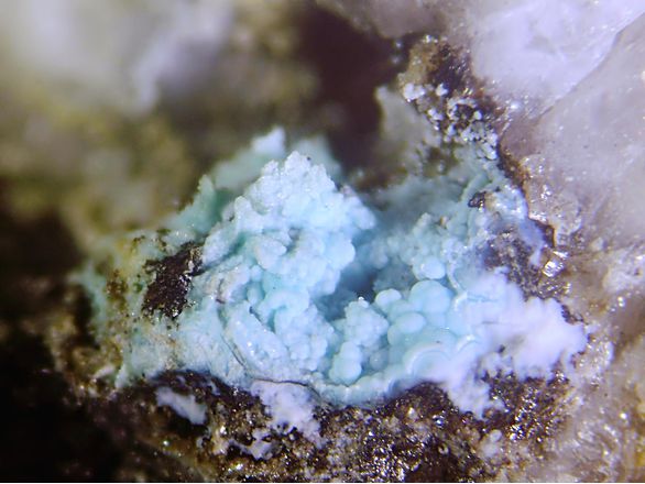


Glücksrad Mine, Oberschulenberg, Clausthal-Zellerfeld, Goslar District, Lower Saxony, Germany