| Classification |
|---|
|
| Species: | Cassiterite |
| Formula: | SnO2 |
| Confirmation |
|---|
|
| Validity: | Believed Valid |
| Data |
|---|
|
| Mineral Data: | Click here to view Cassiterite data |
| Locality Data: | Click here to view Llavisa, Condor Iquiña plateau, Macha area, Chayanta Province, Potosí, Bolivia |
| Data Identifiers |
|---|
|
| Mindat Occurrence Record ID: | 898180 |
| Long-form Identifier: | 1:3:898180:6 |
| GUID (UUID V4): | 39fea730-2336-44f6-9d3d-a8f67551e7ea |
| Nearest other occurrences of Cassiterite |
|---|
|
|
| 19.1km (11.8 miles) | ⓘLípez Huaico mine, Ocurí Municipality, Chayanta Province, Potosí, Bolivia |
| 26.2km (16.3 miles) | ⓘCerro Malmisa, Tinguipaya Municipality, Tomás Frías Province, Potosí, Bolivia |
| 27.0km (16.8 miles) | ⓘColquechaca, Colquechaca Municipality, Chayanta Province, Potosí, Bolivia |
| 39.8km (24.8 miles) | ⓘCharito prospect, Tinguipaya Municipality, Tomás Frías Province, Potosí, Bolivia |
| 53.5km (33.3 miles) | ⓘGalia Itapalluni (Galia Tin Prospect), Cerro Tarqui, Yocalla Municipality, Tomás Frías Province, Potosí, Bolivia |
| 59.2km (36.8 miles) | ⓘAroifilla alluvials (Aroyfilla placer mine), Potosí (Potosí Municipality), Tomás Frías Province, Potosí, Bolivia |
| 59.4km (36.9 miles) | ⓘColavi Mine, Colavi subdistrict, Cornelio Saavedra Province, Potosí, Bolivia |
| 60.8km (37.8 miles) | ⓘCerro Tarqui, Yocalla Municipality, Tomás Frías Province, Potosí, Bolivia |
| 65.9km (40.9 miles) | ⓘEl Molino dredge tailings, El Molino, Cerro Huañaquina, Yocalla Municipality, Tomás Frías Province, Potosí, Bolivia |
| 67.9km (42.2 miles) | ⓘAnton Bravo Mine (Anton Bravo vein), Serranía Huarihuari, Potosí (Potosí Municipality), Tomás Frías Province, Potosí, Bolivia |
| References |
|---|
|
|
| Reference Search (possible matching items) |
|---|
 | | Report (issue) | | No. 12: Bolivia ht of Mineral Collecting N 978-0-9790998-5-4 Publisher Lithographie, LLC Denver, Colorado...specimen 'being sold with the shrine when he was in Bolivia buying mineral specimens in the 1970s. He took...ophyllite; 5. 2 cm tall Cerro Rico, Potosi, B,atillo province, Potosi Andy Seibel col/action Jejf-SC,m/.plwto...Yaalte: 12.5 cm wide Siglo XX Mine, ,U� Bustillo province, Potosi Malty Zinn colkdknt (ex Marv Rausch) Jase...640 200 100 600 The Political Divisions of Bolivia (after United Nations Map No. 3875, Peacekeeping | 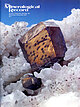 | | Journal (issue) | | to the mine was cut off in 1984. In 1996 the mine area was absorbed into the Saguaro National Monument...for captured 434 British soldiers. Today the mine area, known as “Simsbury Mine and Newgate Prison,” near...trenched it to determine its values, opening an area measuring 10 by 20 feet and 17 feet deep. Beals...expensive dam later broke, flooding the surrounding area (Hurlbert, 1897), it was decided to return to steam...or djurleite. 447 Figure 25. The Bristol mine area today. R. W. Jones photo. Dolomite CaM g(C03)2 The |
|


Llavisa, Condor Iquiña plateau, Macha area, Chayanta Province, Potosí, Bolivia