| Locality type: | Quarry |
| Classification |
|---|
|
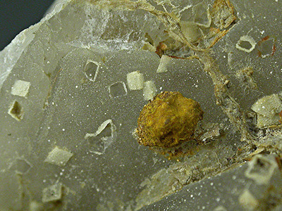
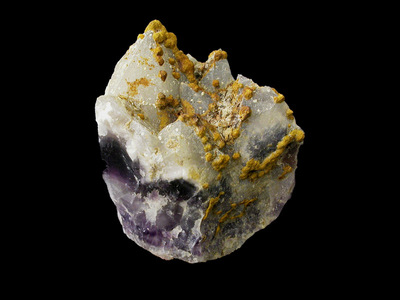
| Species: | 'Limonite' (not an IMA approved species) |
| Confirmation |
|---|
|
| Validity: | Confirmed |
| Confirmation Methods: | Visually Identified |
| Associated Minerals Based on Photo Data: |
|---|
|
| Quartz | ⓘ5 photos of Limonite associated with Quartz at this locality. |
| Amethyst | ⓘ1 photo of Limonite associated with Amethyst at this locality. |
| Data |
|---|
|
| Mineral Data: | Click here to view Limonite data |
| Locality Data: | Click here to view Pégut (Champs des mines), La Chapelle-sur-Usson, Issoire, Puy-de-Dôme, Auvergne-Rhône-Alpes, France |
| Photo Gallery | View Gallery (3 photos) |
| Data Identifiers |
|---|
|
| Mindat Occurrence Record ID: | 922051 |
| Long-form Identifier: | 1:3:922051:5 |
| GUID (UUID V4): | 02c6f064-7265-47bd-8bc7-62d607c3219d |
| Nearest other occurrences of Limonite |
|---|
|
|
| 22.7km (14.1 miles) | ⓘTrinité stream alluvial deposits, Bousseyrolles, Vals-le-Chastel, Brioude, Haute-Loire, Auvergne-Rhône-Alpes, France |
| 25.5km (15.9 miles) | ⓘDoulon stream alluvial deposits, Domeyrat, Brioude, Haute-Loire, Auvergne-Rhône-Alpes, France |
| 25.7km (16.0 miles) | ⓘLa Borie stream alluvial deposits, Champlong, Vieille-Brioude, Brioude, Haute-Loire, Auvergne-Rhône-Alpes, France |
| 28.0km (17.4 miles) | ⓘBouchassou stream alluvial deposits, Ribeyre, Saint-Ilpize, Brioude, Haute-Loire, Auvergne-Rhône-Alpes, France |
| 28.8km (17.9 miles) | ⓘGrenier stream alluvial deposits, Grenier, Saint-Ilpize, Brioude, Haute-Loire, Auvergne-Rhône-Alpes, France |
| 29.8km (18.5 miles) | ⓘCaule stream alluvial deposits, Saint-Ilpize, Brioude, Haute-Loire, Auvergne-Rhône-Alpes, France |
| 32.5km (20.2 miles) | ⓘBancillon stream alluvial deposits, Saint-Ilpize, Brioude, Haute-Loire, Auvergne-Rhône-Alpes, France |
| 36.8km (22.9 miles) | ⓘAllier river alluvial deposits, le Chambon, Cerzat, Brioude, Haute-Loire, Auvergne-Rhône-Alpes, France |
| 42.9km (26.7 miles) | ⓘCouze de Chaudefour stream alluvial deposits, Voissière, Chambon-sur-Lac, Issoire, Puy-de-Dôme, Auvergne-Rhône-Alpes, France |
| 47.1km (29.2 miles) | ⓘBarlet Fluorite Mine (La Drey Mine; La Dreyt Mine; La Costette Mine), Barlet, Langeac, Brioude, Haute-Loire, Auvergne-Rhône-Alpes, France |
| References |
|---|
|
|


Pégut, La Chapelle-sur-Usson, Issoire, Puy-de-Dôme, Auvergne-Rhône-Alpes, France