 | | Report (issue) | | Igneous Biotites from Eastern Nevada and Western Utah By D. E. Lee, 1 E. L. M. Brandt, 1 and R. E. Van...Figure 1. Northeastern Nevada and northwestern Utah, showing locations of samples included in this s...igneous biotites from eastern Nevada and western Utah..................................... 4 INTRODUCTION...from selected plutons in eastern Nevada and western Utah. The purpose of this report is to present those...HDt» COUNTY ~ TOOEU COUNTY I 363-DL-66 ZI ill ILKO COUNTY_ WHIH fiNi COUNTY" TOOtlE COUNTY JUAB |  | | Report (issue) | | from the Marysvale Volcanic Field, West-Central Utah By Randall Lee Mackie and Charles G. Cunningham...rock samples from the Marysvale volcanic field, Utah...................................................rock samples from the Marysvale volcanic field, Utah...................................................Volcanics rocks from the Marysvale volcanic field, Utah............................. Variation in measured...Volcanics rocks from the Marysvale volcanic field, Utah............................. Variation in measured |  | | Report (issue) | | CALITI ES OF UTAH by Kenneth C. Bullock UTAH GEOLOGICAL AND MINERAL SURVEY a division of the UTAH DEPARTMENT...LOCALITIES OF UTAH by Kenneth C. Bullock Nature displays her most common mineral, quartz, in this beautiful...State of Utah. . . . . . . . . . . . . . . . . . . . . . . . . . . . . . . . . . . . . . 1 County Listings.... . . . . . . 1 Chapter II. Mining Districts of Utah . . . . . . . . . . . . . . . . . . . . . . . ..... . . . . . . . 4 Mineral Localities Listed by County . . . . . . . . . . . . . . . . . . . . . . . |  | | Journal (article/letter/editorial) | | near future. Veins of this type are principally of quartz, feldspar, and iron oxides and are known from at...Arizona; (10) Cottonwood area, Arizona; (11) Monroe Canyon,Utah; (12) Mountain Pass, California; and (13)...which contain substantialamounts of bastnaesite. Quartz is the most abundant gangue mineral and is commonlyaccompaniedby...(MacKevett, 1963). This paper will discussonly the quartz-feldspariron oxide-thorium-bearingveins which are...squaremiles. Size and Shape of Thorium Veins The quartz.-feldspar-iron oxide-thorium-bearing veins are |  | | Report (issue) | | UNIVERSITY OF UTAH Alfred C. Emery, President INSTITUTIONAL COUNCIL Edward W. Clyde. . . Joseph E. Bernolfo... . . . Utah State University United States Smelting, Refining and Mining Company · . . . Utah Geological...Association · .. . . . Morton Salt Company · . . . . Utah Petroleum Council · . United States Steel Corporation...Young University · . Kennecott Copper Corporation Utah Sand and Gravel Products Corporation (retired) ...· . . . .First Security Corporation . . . . . . .Utah Mining Association · United Park City Mines Company |  | | Report (issue) | | southeastern and south-central Idaho, eastern Nevada, Utah, western Colorado, southern California, and most...Formation (blue shaly limestone unit) of central Utah and possibly in the lower part of the Tin Mountain...southwestern Montana, southeastern Idaho, and northern Utah. The subzone may be more widespread ENVIRONMENTAL...Member of the Lodgepole Limestone in Montana, Idaho, Utah, and western Wyoming. The shallow-water biofacies...the phosphatic member of the Deseret Limestone in Utah and in equivalent beds in Idaho (see Sando, 1980) |  | | Report (issue) | | Field Guide to Geologic Excursions In Southwestern Utah and Adjacent Areas of Arizona and Nevada Field Trip...meeting in Cedar City, Utah, May 77-9, 2002 Edited By William R. Lund Lund Utah Geological Survey Meeting... Field Guide to Geologic Excursions In Southwestern Utah and Adjacent Areas of Arizona and Nevada Edited...Society of America held at Southern Utah University in Cedar City, Utah. There are a total of eight field...covering various locations and topics in southwestern Utah and adjacent areas of Arizona and Nevada. In addition |  | | Report (issue) | | structure sections of the Logan 30' X 60' quadrangle Utah and Wyoming James H. Dover Open-File Report 85-216...west side of Bear River valley west of Randolph, Utah Tw WASATCH FORMATION (EOCENE)--Red, pale-red,...in areas east of Bear Lake and west of Randolph, Utah Twc Conglomerate Consists of carbonate-cemented...along Big Creek about 4 km southwest of Randolph, Utah, mapped Ksj SAGE JUNCTION FORMATION (LOWER CRETACEOUS)...FORMATION (LOWER CRETACEOUS) Mainly tan to olive-brown quartz sandstone or quartzite, locally with black carbonaceous |  | | Report (volume) | | Geology of the Stewart Flat Quadrangle Caribou County, Idaho By KATHLEEN M. MONTGOMERY and T. M. CHENEY..._______ ________ ______________ ____ __ ___ _ Monroe Canyon Limestone__________________________________...sections of the Stewart flat quadrangle, Caribou County, Idaho. 3. Columnar sections of the Meade Peak...Stratigraphic section of the-1. Monroe Canyon Limestone, Dry Ridge___________ 2. Monroe Canyon Limestone, Freeman...sample lot 1298___ _ _ _ ___ _ _ _ 18. In Pole Canyon, sample lot 1303__ _ _ _ __ _ _ _ __ _ _ _ _ 19 |  | | Report (issue) | | on Amsden Creek in T. 57 N., R. 87 W., Sheridan County, Wyo ------------------------------------------------Geologic...the Darwin Sandstone at Hoback Canyon as a facies of the Mission Canyon Limestone of the Madison Group...Formation I I I Bull Ridge Member Mission Canyon Limestone Tensleep Sandstone Tensleep Sandstone...Sandstone Member Sacajawea Formation Mission Canyon Limestone Tensleep Formation Tensleep Formation...are illustrated on plate 1, sequence" at Hoback Canyon as the uppermost part which presents graphic sections |  | Kerr, Paul F., Brophy, Gerald P., Dahl, Harry M., Green, Jack, Wollard, Louis E. (1957) Marysvale, Utah, Uranium Area - Geology, Volcanic Relations, and Hydrothermal Alteration. GSA Special Paper 64. Geological Society of America | Report (issue) | | Society of America Special Paper 64 MARYSVALE, UTAH, URANIUM AREA GroLocy, Votcanic RELATIONS, AND...and Dr. Bronson String- ham of the University of Utah courteously contributed this type of aid. Local...Rock units ........ Sedimentary basement Bullion Canyon series .. Post-intrusive erosion Dry Hollow latite...volcanic series . Joe Lott tuff...... Basalt ... Sevier River formation Alluvial deposits .... Intrusive...Areal distribution .... Alteration of Bullion Canyon units Alteration of Mount Belknap flows . Alteration |  | | Book | | MINING INDUSTRY By Utah Mining Association 918 Kearns Building Salt Lake City, Utah MILES P. ROMNEY Manager...made to find what material was available to give Utah citizens an account of their mining industry. Most...the mineral deposits and of the mining activity in Utah as time and effort permit. In the writing, we have...I presents the history of mining developments in Utah and deals principally with events that made mining...industry of each Utah county. History, mineral deposits, and mining activity of each Utah county are covered |  | | Report (issue) | | lower Upper Mississippian strata across northwestern Utah By Raymond C. Gutschick Department of Earth Sciences...Page Figure 1. Mississippian strata of northwestern Utah (Hintze, 1973) A. Distribution and thickness of...relations of Mississippian rocks in Pool Canyon, Gold Hill area, western Utah. Detailed section shows Madison-Woodman...Woodman Formation sequence, Buckhorn Canyon section, Dugway Range, Utah 32 7. Mississippian phosphatic...(except for Skunk Spring Canyon occurrence, see fig. 14), northwestern Utah. Solid circle, locality |  | | Book (volume) | | from 18’ to 27’ long. In addition, gem Garnets, Quartz crystals, Topaz and Tourmaline add to the fascination...beds, excavations, etc.Selenite roses. BRULE COUNTY AREA: in the Oacoma zone of the Pierre Fm. On Elm...gray Barite rosette up to 5 or 6 inches. CAMPBELL COUNTY MOUND CITY, W to the Missouri R., regional hillsides...gravels, etc.petrified wood, wood opal. CORSON COUNTY LITTLE EAGLE: area ridges, slopes, stream beds...Guide for Rock Hounds in the United States CUSTER COUNTY AREA: The November Mine, 1.2 mi. SE of the Needles |  | | Report (volume) | | A, Ridge of Brazer limestone northwest of Monroe Canyon, T. 7 S., R. 40 E.; JB, Travertine cliff with...with cave at mouth of Eighteenmile Canyon, sec. 12, T. 7 S., R. 39 E.; C, View near forks of Eighteenmile..._ 26 4. A, Terraces at mouth of Twentyfourmile Canyon, Chesterfield; B, Hill of Swan Peak quartzite in...shales in SE. % sec. 34, T. 4 S., R. 40 E.; (7, Canyon of Blackfoot River below dam in sees. 11 and 12...square miles. In addition the Randolph quadrangle, Utah, which adjoins the Montpelier quadrangle on the |  | | Book | | Forest Service GIS Center of Excellence Ogden, Utah WS Idaho Museum of Natural History 1999 UNIVERSITY...Lake Formation Above the Miocene to Pliocene New Canyon and Clifton Detachment Faults, Malad and Bannock...Late Quaternary History of the Beaverhead River Canyon, Southwestern Montana ZS7 Mervin J. Bartholomew...surrounding regions of Montana, Wyoming, Nevada and Utah. This image is a portion of the digital topographic... Pennsylvanian - Permian rocks exposed in Eight Mile Canyon, southern end of the Lost River Range, southwest |  | | Report (issue) | | The specimens were collected from localities in Utah, Montana, Nevada, Idaho, Colorado, and New Mexico...Jr., Betty Type locality Idaho. Colorado. Idaho. Utah. Early Mississippian _______ --- Do. Ordovician...Permian ____ Utah. Late Mississippian ___________ Montana. _ ____ do _____________________ Utah. _____ do...Santa Fe, New Mexico, and rut Rock Creek, Lake County, Colorado." The same information appears on locality...development of Mountain Canon, and near Echo Park, Utah." Inassix protosepta (cardinal, counter, alars, |  | | Report (issue) | | from large-scale geologic maps, such as State or County geologic maps. The outcrop patterns are necessarily...Northern Anthracite basin of Pennsylvania to Huron County (fig. 4) in north-central Ohio. The western side...State, undifferentiated Ordovician rocks. In Polk County, Ga., the Rockmart Slate of Ordovician age underlies...the Allegheny Front to Altoona in Blair County. From Blair County south into the Virginias the name Hampshire...Greenup 16. Mahoning 6. Lewis 17. Medina 7. Pike' 18. Monroe MARYLAND 19. Muskingum 20. Trumbull 8 . Allegany |  | | Report (volume) | | carbonates A6 Unit 6: Sandy conglomerate A6 Road Canyon Formation A6 Unit 7: Skeletal carbonate and minor...setting Al3 Cathedral Mountain Formation Al3 Road Canyon Formation Al3 Word Formation Al3 Altuda Formation...part of the Cathedral Mountain Formation, the Road Canyon Formation, and the first sandstone member of the...clastic sediments. The upper Cathedral Mountain, Road Canyon, Word, and Altuda Formations are described, and...the Bird Mountain 7 .5-min quadrangle in Brewster County, Texas, is shown (fig. 3). The upper Cathedral |  | | Report (volume) | | Geology of the Rockland and Arbon Quadrangles, Power County, Idaho By DONALD E. TRIMBLE and WILFRED J. CARR... . . . . . . . . . . . . . . . . . . . Manning Canyon Shale . . . . . . . . . . . . . . . . . . . . ...thrust faults in southeastern Idaho and northern Utah. . . . . . . . . . . . . . . . 16. Map showing structure...at southwest tip of ridge above road into Buck Canyon, in the NW 1/4NW 1/4 sec. 1, T. 10 S., R. 31 E.... . . . . . 6. Begins in saddle north of Water Canyon in the NW 1/4NE 1/4 sec. 26, T. 9 S., R. 31 E. |  | | Report (volume) | | Geology of the ; Paradise Quadrangle i>. ** Cache County, Utah 1 By THOMAS E. MULLENS and GLEN A. IZETT '*...1924- Geology of the Paradise quadrangle, Cache County, Utah, by Thomas E. Mullens and Glen A. Izett. Washington...cm. (U.S. Geological 1. Geology Utah Cache Co. 2. Ore-deposits Utah Cache Co. I. Izett, Glen Arthur,...author. II. Title: Paradise quadrangle, Cache County, Utah. (Series) For sale by the Superintendent of...Series_-____--__-----_-_____---_-_-_-_--__Water Canyon Formation. __. __________________________ . Si |  | | Report (issue) | | Clearance Center, 222 Rosewood Drive, Danvers, MA 01923, USA, phone (978) 750-8400, http://www.copyright.com...of tuffs were derived from explosive volcanism in Utah and Nevada. Evans and Welzenbach present the first...of tuffs were derived from explosive volcanism in Utah and Nevada. We have identified only one tuff (in...TUFFS SAMPLED IN THIS STUDY Map Location Locality County Legal Locations(s) Tuffs Sampled LMA(s)* WyomiING...bed that resembles a tuff near Akron, Washington County, Colorado. Despite this bed’s white color, widespread |  | | Report (volume) | | 74, Ph miles east of Dutchtown, Cape Girardeau County, Mo. Type section cut by northtrending fault with...stream in NEIA sec. 33, T. 16 N., R. 14 E, Wayne County. Named after village of Abington, about 3 miles...Named for Adam Peak in Osgood Mountains, Humboldt County. Occupies belt about 21f2 miles long on western...Goughs Canyon on south. Also occurs as fault-bounded blocks along crest of range from Goughs Canyon to Perforate...Perforate Canyon. Formation is on thrust plate that overrides strata of Etchart limestone at south end |  | | Report (issue) | | Montana, by Donald L. Smith and Ernest H. Gilmour Y. Utah, by John E. Welsh and Harold J. Bissell Z. Arizona...Ernest H. Gilmour______________________________ Y. Utah., by John E. Welsh and Harold J. BisselL_______...from Lee County in the southeast corner of the State northwestward to southeastern Kossuth County in north-central...contain quartz are common in the southeastern outcrop belt. Chalcedonic chert and crystalline quartz, dominantly...micaceous dolomitic limestone that has a minor quartz san~ fraction. It is restricted to southern M7 |  | | Journal (article/letter/editorial) | | of a tributary of Agassiz glacier (no negative). Canyon on the Chaix hills (No. 400). Marginal drainage...the left (No. 68). Girdled glacier and Granite canyon (No. 40). Diorite peaks, from snow dome (No. 58)... showing mouths of Girdled glacier and Granite canyon (No. 22). Ice-front of Muir glacier from the west...107). 95. Dark limestone, with schistosity and quartz, 1,896 miles above mouth of Gens de Larg river;...near foot of glacier (No. 150). 116. Foot of Woods canyon on Copper river, looking up stream. 117. Plateau |
|

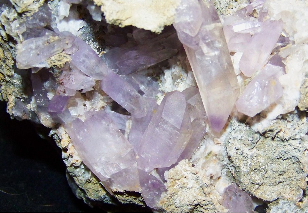


Monroe Canyon, Sevier County, Utah, USA