Home PageAbout MindatThe Mindat ManualHistory of MindatCopyright StatusWho We AreContact UsAdvertise on Mindat
Donate to MindatCorporate SponsorshipSponsor a PageSponsored PagesMindat AdvertisersAdvertise on Mindat
Learning CenterWhat is a mineral?The most common minerals on earthInformation for EducatorsMindat ArticlesThe ElementsThe Rock H. Currier Digital LibraryGeologic Time
Minerals by PropertiesMinerals by ChemistryAdvanced Locality SearchRandom MineralRandom LocalitySearch by minIDLocalities Near MeSearch ArticlesSearch GlossaryMore Search Options
The Mindat ManualAdd a New PhotoRate PhotosLocality Edit ReportCoordinate Completion ReportAdd Glossary Item
Mining CompaniesStatisticsUsersMineral MuseumsClubs & OrganizationsMineral Shows & EventsThe Mindat DirectoryDevice SettingsThe Mineral Quiz
Photo SearchPhoto GalleriesSearch by ColorNew Photos TodayNew Photos YesterdayMembers' Photo GalleriesPast Photo of the Day GalleryPhotography
╳Discussions
💬 Home🔎 Search📅 LatestGroups
EducationOpen discussion area.Fakes & FraudsOpen discussion area.Field CollectingOpen discussion area.FossilsOpen discussion area.Gems and GemologyOpen discussion area.GeneralOpen discussion area.How to ContributeOpen discussion area.Identity HelpOpen discussion area.Improving Mindat.orgOpen discussion area.LocalitiesOpen discussion area.Lost and Stolen SpecimensOpen discussion area.MarketplaceOpen discussion area.MeteoritesOpen discussion area.Mindat ProductsOpen discussion area.Mineral ExchangesOpen discussion area.Mineral PhotographyOpen discussion area.Mineral ShowsOpen discussion area.Mineralogical ClassificationOpen discussion area.Mineralogy CourseOpen discussion area.MineralsOpen discussion area.Minerals and MuseumsOpen discussion area.PhotosOpen discussion area.Techniques for CollectorsOpen discussion area.The Rock H. Currier Digital LibraryOpen discussion area.UV MineralsOpen discussion area.Recent Images in Discussions


337655
LocalitiesAllie Island Mine, Allie Island, Kenora District, Ontario, Canada
19th Jan 2020 18:55 UTCDon Windeler
Folks:
I recently added this locality to MinDat on the basis of a specimen and some research. I have a couple of related questions, both on how to refine the entry and on improving my MinDat editing skills.
I recently added this locality to MinDat on the basis of a specimen and some research. I have a couple of related questions, both on how to refine the entry and on improving my MinDat editing skills.
On the locality:
The Mines Register reference indicates the prospect was found on the east side of the island. I put a coordinate in the middle of that side with an area of 3 km2 that would cover half the island in an “error bubble”. However, there is an East Allie Island immediately adjacent to Allie Island. Can’t see anything on the satellite views that would suggest where the prospect might be, which is hardly surprising since the reference is a hundred years old and the islands heavily vegetated. Given the specimens I’ve seen seem more likely to be more recently, has anyone collected the locality who might be willing to refine the location and which island it’s on? (PM me if you'd prefer to discuss out of public view.)
Related to MinDat locality editing in general:
I’ve noticed that the map view for a locality sometimes zooms right to it, while other times covers a wide area. In this locality, for example, the island itself is only 2km long but the view is almost 200km wide. It also doesn’t show any error bubble around the coordinates, something that appears on some of the other localities. What do I need to do for these to display correctly?
Finally, how does one get the locality to show up in the MinDat search? At least as of today, even an exact entry of “Allie Island Mine” in the Locality search line does not yield this loc.
Thanks for your patience with my questions – my goal is to learn how to do it right so I avoid making messes others need to clean up.
Cheers,
D.

20th Jan 2020 13:50 UTCAndrew Debnam 🌟
Hi Don, the government agency in Ontario (Ministry Energy, Northern Development and Mines) that keeps records on mines, claims, prospects etc does have a file on this locality. It is a MDI file-mineral deposit inventory. The info however is scant. I have copied it below for you.
Mineral Deposit Inventory Record MDI52E09SW00041: Allie Island Copper Occurrence
/mndmfiles/mdi/data/records
1/7/2020 4k 8 hits
Mineral Deposit Inventory for Ontario
Ministry of Energy, Northern Development and Mines
Permanent Link to this Record: MDI52E09SW00041
Deposit: MDI52E09SW00041
General
Mineral Deposit Identification
Deposit Name(s)
Allie Island Copper Occurrence - 1911
Related Deposit Type
None
Deposit Status
occurrence
Date Created
1999-Jun-15
Date Last Modified
2005-Dec-07
Created By
P Hinz
Revised By
P Hinz
Commodities
Primary Commodities: copper
Location
Township or Area: Yellowgirl Bay Area
Latitude: 49° 35' 17.92" Longitude: -94° 26' 29.96"
UTM Zone: 15 Easting: 395803 Northing: 5493857 UTM Datum: NAD83
Resident Geologist District: Kenora
NTS Grid: 52E09SW
Point Location Description: N/A
Location Method: data compilation
Access Description: N/A
22nd Jan 2020 04:38 UTCDon Windeler
Thank you for helping out. I've played around with the coordinates in the record you provided and they end up in the water to the SE of East Allie Island. That does suggest that the prospect might be on (today's) East Allie Island rather than the east of Allie Island, but it may be I just have to make the "area" value bigger.
Still haven't figured out how to access the "margin of error" field that shows up on some MinDat localities -- it's not anywhere on this loc as I edit it.
Cheers,
D.
22nd Jan 2020 05:39 UTCKeith Compton 🌟 Manager
The margin of error is the result of an algorithm that looks for known points within and outside the hierarchy for a locality. The more localities nearby, the the blue circle width is smaller. If the nearest other localities are a distance away then the blue circle will simply be very large.
I've never considered even having a need to "access" the"margin of error", let alone edit it.
As far as I am aware once the coordinates are added to a locality the blue circle will only appear for unmapped sites and it disappears for the mapped locality.
22nd Jan 2020 06:33 UTCKeith Compton 🌟 Manager
The following reading may assist:
From the Twentieth Annual Report of the Bureau of Mines, 1911, Vol.XX, Part I. Ontario Bureau of Mines.
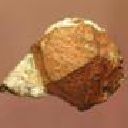
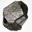
"On June 5th, having received supplementary instructions to examine the reported discovery of copper on Allie island, Lake of the Woods, I visited the claims on this island which have been taken up by F.W. Moore. These copper locations are on the south side of the island and are in a decomposed rock which consists principally of chlorite or serpentine. On exposure to the air this rock slacks like lime or marl, and resembles the serpentine from Hoboken, New Jersey, and the decomposed serpentine from Lancaster county, Pennsylvania. On first examining this rock no trace of copper was to be seen, bait on crushing and panning the crushed material, small pellets, and crystals of copper were obtained. The crystals which are found are invariably octahedral in form, and vary in size from mere grains up to one-fourth of an inch in diameter. The chloritic rock in which the copper occurs is apparently the result of the decomposition of a diabase with which it is in contact, and some specimens when broken open exhibit a nucleus of comparatively fresh diabase with an outer zone of the chloritic rock. A search was made for sulphides in the diabase but without success, although a few small specks too minute to be identified in the field were found, which resemble pyrrhotite, Four claims had been staked out, and two shafts about twenty feet deep had been sunk. The amount of copper found in the rock up to that time was apparently not sufficient to be of economic value. A second visit was made on September 1st. During the summer a new shaft about forty feet deep had been sunk near the more promising of the earlier shafts, and at this depth the rock was still soft and chloritic. On going down into the shaft a considerable improvement was noted in the character of the ore. The mine is just west of French Narrows, about 14 miles from Kenora. In case this property proves of economic value there should be a further development in copper mining on Lake of the Woods, as the same type of rock having similar geological relations is found on the wear, side of the large island between Queer and Middle islands."
Further:
Slatterly, J. in A Catalogue of the Ontario Localities represented by the Mineral Collection of the Royal Ontario Museum. Ontario Geological Survey Miscellaneous Paper, MP 70, the following is provided:
"KENORA DISTRICT East Allie Island (S side), Lake of the Woods, 12 miles S of Kenora NTS: 52E/09W MAP: ODM 2115, Kenora-Fort Frances Sheet ODM 39f, Bigstone Bay Area REF: ODM 1911, Vol.20, pt.l, p.175-176 ODM 1973, MP54, p.14 OCC: Native copper (octahedral crystals) in altered sheared basalt. ROM: M8795,M11101,M31721, M32196"
So it appears that the "mine" may not in fact be a mine but rather a a copper occurrence and is/was located on the southern side of East Allie Island.
The locality name might in be more correct as: Copper occurrence, East Allie Island, Kenora District, Ontario, Canada.
It is also unclear from what I have read as to whether the deposit operated as a mine.
Also reading from the above I don't see how a locality can be just west of the French Narrows and also on the south side of East Allie Island. But certainly more likely that the deposit is on East Allie Island.
Don, the locality you actually uploaded may in fact be totally incorrect.
Cheers
22nd Jan 2020 14:14 UTCAndrew Debnam 🌟
23rd Jan 2020 05:31 UTCDon Windeler
Keith, you're probably right that my entry is incorrect, which kind of makes a couple of my points. (1) I'm trying to learn the right way to do stuff, and (2) I thought of the margin of error as how one indicated geographic uncertainty (but that apparently isn't accessible.) Let me explain, leaving aside which island is right to start.
The MinDat manual says to start with some other point in the hierarchy and add from there. Allie Island shows up as a geographic feature when I searched ( https://www.mindat.org/feature-5883991.html ), but I couldn't figure out how to add a mine from that record. Instead I went up one level in the MinDat localities to the Kenora District, created Allie Island as a new location, and made up a centroid for the island.
From there, I added the Allie Island Mine as a sublocality and dragged the coordinate to the east side of the island. I know that's not a precise location, however, so I want an uncertainty bubble. The only option I have is the feature area field, which probably is intended for something like a big mining district rather than a fuzzy location.
I think what would be more appropriate in this location would be a generic location associated with one of the the two islands (Allie Island or East Allie Island) that show up as "Features" rather than plopping a specific coordinate down, but that's where I'm making mistakes. In my real world job, we often use a best-estimate coordinate with an error fuzzball, which is why I'm trying to work with that here...
Sorry for a really long note that probably should get discussed somewhere outside of an obscure source of ugly locality coppers!
D.


Mindat.org is an outreach project of the Hudson Institute of Mineralogy, a 501(c)(3) not-for-profit organization.
Copyright © mindat.org and the Hudson Institute of Mineralogy 1993-2024, except where stated. Most political location boundaries are © OpenStreetMap contributors. Mindat.org relies on the contributions of thousands of members and supporters. Founded in 2000 by Jolyon Ralph.
Privacy Policy - Terms & Conditions - Contact Us / DMCA issues - Report a bug/vulnerability Current server date and time: May 9, 2024 12:21:28