| Locality | Latitude | Longitude | Distance | Bearing |
|---|
| U. S. Silica (Pennsylvania Glass Sand Company Quarry; Berkeley Works Quarry), Berkeley Springs, Morgan County, West Virginia, USA | 39° 39' 21" N | 78° 12' 45" W | 1.2km (0.7 miles) | |
| Whitmeyer-Bridges Quarry, Hancock, Washington County, Maryland, USA | 39° 42' 0" N | 78° 10' 59" W | 4.7km (2.9 miles) | |
| Barton Deposit, Washington County, Maryland, USA | 39° 43' 3" N | 78° 13' 17" W | 6.7km (4.1 miles) | |
| I-68 Roadcut, Hancock, Washington County, Maryland, USA | 39° 42' 11" N | 78° 15' 20" W | 6.8km (4.2 miles) | |
| Southeast Indian Springs Ore Bank, Washington County, Maryland, USA | 39° 38' 8" N | 77° 59' 35" W | 17.9km (11.1 miles) | |
| Wheatstone Ore Bank, Washington County, Maryland, USA | 39° 40' 23" N | 77° 58' 36" W | 19.1km (11.9 miles) | |
| North Green Spring Furnace Ore Bank, Washington County, Maryland, USA | 39° 38' 4" N | 77° 58' 41" W | 19.2km (11.9 miles) | |
| North Mt. Area, Washington County, Maryland, USA | 39° 38' 9" N | 77° 58' 29" W | 19.4km (12.1 miles) | |
| Green Spring Ore Bank, Washington County, Maryland, USA | 39° 37' 42" N | 77° 58' 18" W | 19.9km (12.3 miles) | |
| Northeast Green Spring Furnace Bank, Washington County, Maryland, USA | 39° 38' 56" N | 77° 57' 45" W | 20.4km (12.7 miles) | |
| Charles Ore Bank, Washington County, Maryland, USA | 39° 38' 31" N | 77° 57' 24" W | 20.9km (13.0 miles) | |
| Whips Cove, Fulton County, Pennsylvania, USA | 39° 52' 9" N | 78° 13' 55" W | 23.4km (14.6 miles) | |
| Wilson Farm Ore Bank, Washington County, Maryland, USA | 39° 42' 2" N | 77° 54' 29" W | 25.4km (15.8 miles) | |
| McLaughlin Ore Bank, Washington County, Maryland, USA | 39° 41' 6" N | 77° 53' 22" W | 26.7km (16.6 miles) | |
| Benders Cave, Berkeley County, West Virginia, USA | 39° 31' 35" N | 77° 55' 4" W | 28.4km (17.6 miles) | |
| Pinesburg Quarry, Williamsport, Washington County, Maryland, USA | 39° 37' 22" N | 77° 52' 6" W | 28.7km (17.8 miles) | |
| Little Mountain Deposit, Hampshire County, West Virginia, USA | 39° 26' 11" N | 78° 22' 59" W | 29.4km (18.3 miles) | |
| Martinsburg Quarry (Capitol Cement Company division of Martin Marietta Corporation), Berkeley County, West Virginia, USA | 39° 27' 6" N | 77° 57' 47" W | 30.8km (19.1 miles) | |
| Clay Mine-Victor Cushwa (Victor Cushwa and Sons Inc.), Washington County, Maryland, USA | 39° 38' 7" N | 77° 49' 11" W | 32.7km (20.3 miles) | |
| Victor Cushwa and Sons Pit, Washington County, Maryland, USA | 39° 38' 7" N | 77° 49' 11" W | 32.7km (20.3 miles) | |
| Continental Clay Products Company Pit, Berkeley County, West Virginia, USA | 39° 25' 59" N | 77° 57' 14" W | 32.9km (20.4 miles) | |
| Blair Quarry & plant, Berkeley County, West Virginia, USA | 39° 27' 29" N | 77° 54' 44" W | 33.3km (20.7 miles) | |
| Inwood Quarry, Berkeley County, West Virginia, USA | 39° 21' 41" N | 78° 2' 8" W | 36.1km (22.4 miles) | |
| Allegany Aggregates Inc. Bedrock Quarry (Martin Mountain Quarry), Allegany County, Maryland, USA | 39° 42' 32" N | 78° 37' 2" W | 36.1km (22.5 miles) | |
| Horst Property, Hampshire County, West Virginia, USA | 39° 20' 30" N | 78° 25' 32" W | 40.3km (25.1 miles) | |
| Rockdale Quarry, Hagerstown, Washington County, Maryland, USA | 39° 38' 42" N | 77° 43' 11" W | 41.1km (25.6 miles) | |
| Frankstown (Unincorporated township), Blair County, Pennsylvania, USA | 40° 0' 0" N | 78° 0' 0" W | 41.5km (25.8 miles) | |
| Guepl Deposit, Allegany County, Maryland, USA | 39° 35' 7" N | 78° 40' 51" W | 42.0km (26.1 miles) | |
| Old Henry Kerns Place Prospect, Frederick County, Virginia, USA | 39° 16' 52" N | 78° 15' 46" W | 42.5km (26.4 miles) | |
| Shepherdstown, Jefferson County, West Virginia, USA | 39° 25' 48" N | 77° 48' 14" W | 42.5km (26.4 miles) | |
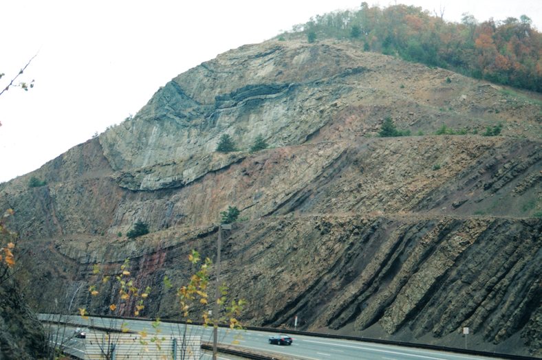


I-68 Roadcut, Hancock, Washington County, Maryland, USA