| Locality | Latitude | Longitude | Distance | Bearing |
|---|
| Young Deer Creek, Forsyth County, Georgia, USA | 34° 11' 29" N | 84° 3' 30" W | 0.0km (0.0 miles) | |
| Hansard Prospect, Forsyth County, Georgia, USA | 34° 10' 17" N | 84° 5' 15" W | 3.5km (2.2 miles) | |
| Buford Dam site, Buford, Gwinnett County, Georgia, USA | 34° 9' 38" N | 84° 4' 29" W | 3.8km (2.3 miles) | |
| Lot 70 2nd District (Lyons; Zamoda Au Prospect), Forsyth County, Georgia, USA | 34° 12' 0" N | 84° 5' 59" W | 3.9km (2.4 miles) | |
| Cumming Quarry, Forsyth County, Georgia, USA | 34° 11' 0" N | 84° 8' 26" W | 7.6km (4.8 miles) | |
| Banks Property, Hall County, Georgia, USA | 34° 12' 29" N | 83° 58' 29" W | 7.9km (4.9 miles) | |
| Roadcut, Fourmile Creek, Forsyth County, Georgia, USA | 34° 15' 1" N | 84° 0' 35" W | 7.9km (4.9 miles) | |
| Fourmile Creek, Forsyth County, Georgia, USA | 34° 15' 7" N | 84° 0' 43" W | 7.9km (4.9 miles) | |
| Owens Mine, Buford, Gwinnett County, Georgia, USA | 34° 6' 59" N | 84° 1' 59" W | 8.7km (5.4 miles) | |
| Piedmont Mine, Buford, Gwinnett County, Georgia, USA | 34° 6' 59" N | 84° 1' 59" W | 8.7km (5.4 miles) | |
| Sawnee Mountain, Forsyth County, Georgia, USA | 34° 14' 40" N | 84° 7' 59" W | 9.1km (5.6 miles) | |
| Settles Property, Forsyth County, Georgia, USA | 34° 6' 39" N | 84° 6' 29" W | 10.1km (6.3 miles) | |
| Level Creek Gold Mine, Gwinnett County, Georgia, USA | 34° 5' 34" N | 84° 3' 22" W | 11.0km (6.8 miles) | |
| Winns Ferry (Williams Ferry), Hall County, Georgia, USA | 34° 13' 55" N | 83° 56' 57" W | 11.0km (6.8 miles) | |
| Muddy Creek Prospect, Hall County, Georgia, USA | 34° 14' 0" N | 83° 56' 39" W | 11.5km (7.1 miles) | |
| Mary Thomas Property, Forsyth County, Georgia, USA | 34° 9' 43" N | 84° 11' 24" W | 12.6km (7.8 miles) | |
| Unnamed Ocher Deposit (10216483), Forsyth County, Georgia, USA | 34° 7' 36" N | 84° 11' 2" W | 13.6km (8.5 miles) | |
| Faver Mine, Forsyth County, Georgia, USA | 34° 7' 44" N | 84° 11' 10" W | 13.7km (8.5 miles) | |
| Friendship Quarry, Hall County, Georgia, USA | 34° 7' 53" N | 83° 55' 11" W | 14.4km (9.0 miles) | |
| Harrison Prospect, Forsyth County, Georgia, USA | 34° 17' 41" N | 84° 10' 1" W | 15.2km (9.5 miles) | |
| Suwanee, Gwinnett County, Georgia, USA | 34° 3' 5" N | 84° 4' 16" W | 15.6km (9.7 miles) | |
| Suwanee Mine (Level Creek Mine), Suwanee, Gwinnett County, Georgia, USA | 34° 2' 59" N | 84° 3' 59" W | 15.8km (9.8 miles) | |
| Bennett Prospect, Forsyth County, Georgia, USA | 34° 13' 41" N | 84° 13' 34" W | 16.0km (9.9 miles) | |
| Vickers Prospect, Hall County, Georgia, USA | 34° 14' 0" N | 83° 53' 19" W | 16.3km (10.1 miles) | |
| Sheltonville, Forsyth County, Georgia, USA | 34° 3' 23" N | 84° 7' 53" W | 16.5km (10.2 miles) | |
| Little Property (Collins; Campbell), Forsyth County, Georgia, USA | 34° 3' 40" N | 84° 9' 20" W | 17.1km (10.6 miles) | |
| McBrayer Prospect, Forsyth County, Georgia, USA | 34° 17' 52" N | 84° 11' 58" W | 17.5km (10.9 miles) | |
| W. T. Fowler Placer, Forsyth County, Georgia, USA | 34° 13' 0" N | 84° 14' 50" W | 17.6km (10.9 miles) | |
| Waltz & Bates Mines (Iza Clayton Mines), Cherokee County, Georgia, USA | 34° 11' 23" N | 84° 16' 0" W | 19.2km (11.9 miles) | |
| Branden Property, Dawson County, Georgia, USA | 34° 22' 38" N | 84° 2' 28" W | 20.7km (12.9 miles) | |
Minerals recorded nearby (within 20 km)
Rock types recorded nearby (within 20 km)
Entries shown in red are rocks recorded for this region.
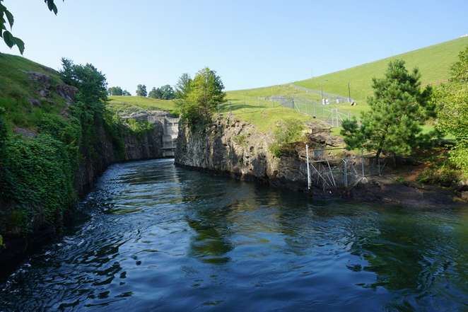


Buford Dam site, Buford, Gwinnett County, Georgia, USA