| Locality | Latitude | Longitude | Distance | Bearing |
|---|
| US Forest Service-Upper Mitchell, Clackamas County, Oregon, USA | 45° 5' 57" N | 122° 1' 19" W | 0.0km (0.0 miles) | |
| US Forest Service-Lower Mitchell, Clackamas County, Oregon, USA | 45° 5' 30" N | 121° 59' 48" W | 2.1km (1.3 miles) | |
| US Forest Service 100, Clackamas County, Oregon, USA | 45° 5' 6" N | 122° 2' 35" W | 2.3km (1.4 miles) | |
| Oak Grove Fork, Clackamas County, Oregon, USA | 45° 4' 59" N | 121° 59' 27" W | 3.0km (1.9 miles) | |
| US Forest Service-Boneyard, Clackamas County, Oregon, USA | 45° 6' 47" N | 122° 3' 30" W | 3.3km (2.0 miles) | |
| US Forest Service 076 (US Forest Service 76), Clackamas County, Oregon, USA | 45° 5' 13" N | 121° 58' 51" W | 3.5km (2.2 miles) | |
| Oak Grove Fork, Clackamas River localities, Clackamas County, Oregon, USA | 45° 4' 28" N | 122° 3' 3" W | 3.5km (2.2 miles) | |
| Ames - Bancroft (Oregon Quicksilver), Oak Grove Fork, Clackamas County, Oregon, USA | 45° 4' 46" N | 121° 58' 48" W | 4.0km (2.5 miles) | |
| Nisbet (Oregon Quicksilver), Oak Grove Fork, Clackamas County, Oregon, USA | 45° 4' 49" N | 121° 58' 28" W | 4.3km (2.7 miles) | |
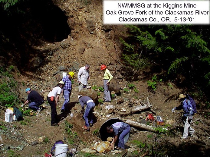
| Kiggins, Oak Grove Fork, Clackamas County, Oregon, USA | 45° 4' 37" N | 121° 58' 23" W | 4.6km (2.8 miles) | |
| US Forest Service 111, Clackamas County, Oregon, USA | 45° 3' 30" N | 122° 0' 8" W | 4.8km (3.0 miles) | |
| US Forest Service-Pixie, Clackamas County, Oregon, USA | 45° 5' 50" N | 122° 4' 59" W | 4.8km (3.0 miles) | |
| US Forest Service 075 (US Forest Service 75), Clackamas County, Oregon, USA | 45° 6' 46" N | 121° 57' 30" W | 5.2km (3.2 miles) | |
| US Forest Service 099 (US Forest Service 99), Clackamas County, Oregon, USA | 45° 4' 42" N | 122° 5' 15" W | 5.6km (3.5 miles) | |
| US Forest Service 113, Clackamas County, Oregon, USA | 45° 3' 12" N | 121° 59' 12" W | 5.8km (3.6 miles) | |
| US Forest Service 108, Clackamas County, Oregon, USA | 45° 4' 15" N | 121° 57' 19" W | 6.1km (3.8 miles) | |
| US Forest Service 073 (US Forest Service 73), Clackamas County, Oregon, USA | 45° 7' 35" N | 121° 57' 2" W | 6.4km (4.0 miles) | |
| US Forest Service-Kink Creek, Clackamas County, Oregon, USA | 45° 4' 0" N | 121° 57' 15" W | 6.5km (4.0 miles) | |
| US Forest Service 112, Clackamas County, Oregon, USA | 45° 3' 55" N | 121° 57' 19" W | 6.5km (4.0 miles) | |
| US Forest Service 109, Clackamas County, Oregon, USA | 45° 4' 9" N | 121° 56' 49" W | 6.8km (4.2 miles) | |
| US Forest Service 110, Clackamas County, Oregon, USA | 45° 4' 9" N | 121° 56' 48" W | 6.8km (4.2 miles) | |
| US Forest Service-Sink, Clackamas County, Oregon, USA | 45° 8' 12" N | 121° 57' 3" W | 7.0km (4.3 miles) | |
| US Forest Service-Switch Creek, Clackamas County, Oregon, USA | 45° 2' 8" N | 122° 0' 33" W | 7.1km (4.4 miles) | |
| US Forest Service 114, Clackamas County, Oregon, USA | 45° 2' 34" N | 121° 58' 36" W | 7.2km (4.5 miles) | |
| US Forest Service-Frazier Mt, Clackamas County, Oregon, USA | 45° 7' 13" N | 121° 56' 3" W | 7.3km (4.5 miles) | |
| US Forest Service 101, Clackamas County, Oregon, USA | 45° 3' 29" N | 122° 5' 47" W | 7.4km (4.6 miles) | |
| US Forest Service-Old No. 50, Clackamas County, Oregon, USA | 45° 3' 56" N | 122° 6' 25" W | 7.6km (4.7 miles) | |
| US Forest Service-Jack Davis, Clackamas County, Oregon, USA | 45° 2' 3" N | 122° 4' 5" W | 8.1km (5.0 miles) | |
| US Forest Service 070 (US Forest Service 70), Clackamas County, Oregon, USA | 45° 7' 41" N | 122° 7' 0" W | 8.1km (5.0 miles) | |
| US Forest Service 072 (US Forest Service 72), Clackamas County, Oregon, USA | 45° 8' 12" N | 121° 55' 59" W | 8.1km (5.1 miles) | |
Minerals recorded nearby (within 8.1 km)
Rock types recorded nearby (within 8.1 km)
Entries shown in red are rocks recorded for this region.
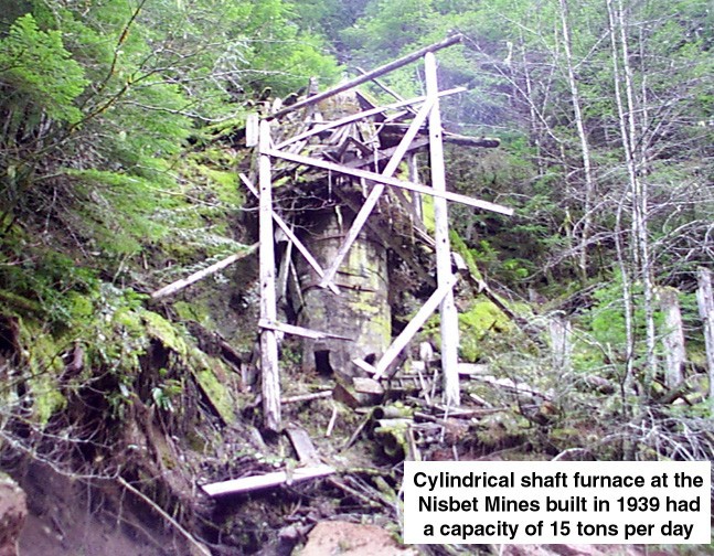


Nisbet, Oak Grove Fork, Clackamas County, Oregon, USA